

Exploiting Earth Observation data
ESRIN is continuously adding to its archive of Earth Observation data, the largest collection of its kind in Europe. This information is a unique source of environmental information that serves as the basis for a steadily widening range of applications.
The scientific community remain the leading users of Earth Observation products, and it is scientific research employing that data that originates most operational applications of satellite data.
It is ESRIN's responsibility to make its data available to scientists, to liaise with the scientific community and to harness their input into future satellite missions, sensors and products.
Researchers can apply to receive Earth Observation data at cost price through the ESRIN-hosted Earth Observation Principal Investigator Portal. They are expected to report on project progress at least twice a year through this Portal, and also to publish intermediate results in this way.
Regular Announcements of Opportunity are also accessed through the Portal. These give researchers the opportunity to make use of Earth Observation data completely free of charge within particular designated fields.
ESA researchers based at ESRIN work with external scientific partners to calibrate and validate the outputs of ESA's many orbiting Earth Observation sensors, and refine the processing algorithms that turn raw data into useful geophysical values. This activity is essential to ensure the reliability of satellite data. ESRIN also regularly hosts major scientific conferences and workshops concerning topics related to Earth Observation.
Turning science into services
Another part of ESRIN's role is to increase the wider take-up of satellite data by supporting development of innovative Earth Observation-derived information products and services. ESRIN does this through a series of programmes that foster partnerships between research institutions, service companies and user organisations.
The Data User Element (DUE) is aimed at institutional users who are tasked with acquiring specific geographic or environmental information but who currently do not make use of Earth Observation data.
A DUE project involves the creation of sample Earth Observation products or services tailored to the user's operational requirements. Having raised a participating institution's awareness of the applicability of Earth Observation to their day-to-day activities, the intention is then to transform project results into a self-sustaining service.

The Earth Observation Market Development (EOMD) programme complements DUE by working from the service provider side, seeking to build overall industrial capacity in the Earth Observation field.
EOMD does this by fostering links between complementary companies to generate end-to-end service chains to turn scientific satellite results into commercial products that can be offered for sale by self-supporting businesses. The GMES Services Element (GSE) is establishing a suite of operational Earth Observation-based services aimed at supporting the work of scientists, policy makers and implementers within government agencies, non-governmental organisations and key international scientific bodies. GSE is the first step in ESA and the European Commission's far-reaching Global Monitoring for Environment and Security (GMES) endeavour, intended to bring together all available information sources to develop an independent capability to gather accurate and timely global information in support of European environmental and security goals.
International cooperation
International cooperation is a significant way of leveraging the returns from ESA Earth Observation activities. ESRIN liaises with international bodies including the Committee on Earth Observing Satellites (CEOS) that coordinate space agencies' mission planning, data products and policies in the field of planetary monitoring.
In addition, ESRIN is the centre overseeing ESA's participation in the International Charter on Space and Major Disasters, which puts Earth Observation resources of its member space agencies at the disposal of civil protection authorities in the event of a natural or man-made disaster.
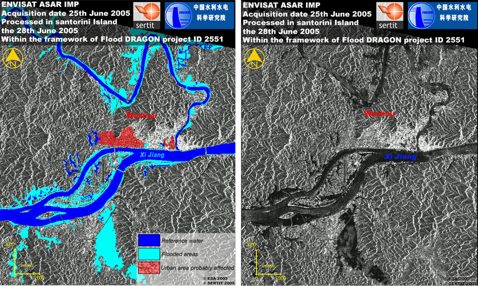
The centre also provides support to various international ESA initiatives including the Tiger Initiative, supplying satellite data to African users in support of fostering sustainable development in the field of water management, and the Dragon Programme, an initiative between China and ESA to encourage joint European and Chinese research across a number of thematic areas, concentrating on Chinese territory.


