Precision EGNOS satnav sparking quiet revolution in aircraft landings
If you’ve taken a flight in Europe recently, then the chances are growing that you’ve been a pioneer EGNOS user. Satellites in orbit would have guided your airliner’s descent, rather than signals beamed from the ground. You wouldn’t have felt any difference – except for possibly a smoother ride.
More than 180 European airports have now been certified to make use of the ESA-designed European Geostationary Navigation Overlay Service, EGNOS, for approaches to given runways. This includes approaches at major hubs such as Paris Charles de Gaulle, Frankfurt and Amsterdam Schiphol. Thanks to EGNOS, safe landings would still be possible even if an airport were shut down entirely.
Sharpening the precision of US GPS satnav signals over most European territory, EGNOS was designed to make satnav reliable enough for safety-critical aviation employment, but has found a wide range of other uses, from agriculture to road, rail and maritime transport.

An EGNOS app is available from the Apple and Google Play stores, offering easy access to all EGNOS-related information, including the different EGNOS services, official documentation, historical and current performance data, support material and contact with the 24/7 EGNOS helpdesk.
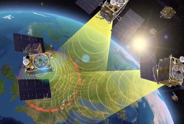
EGNOS is based on a network of monitoring stations across Europe that perform independent measurements of GPS signals, so that corrections can be calculated to boost satnav positioning performance. These results are passed to users immediately via a trio of geostationary satellites.

The service is allowed just a one in 10 million chance of error. If this tolerance is exceeded then EGNOS users are informed within six seconds. The result is that EGNOS-augmented signals meet the extremely high performance standards set out by the International Civil Aviation Authority, adapted for Europe by Eurocontrol, the European Organisation for the Safety of Air Navigation.
EGNOS operations are the responsibility of the European Global Navigation Satellite System Agency (GSA) of the European Commission and run by the ESSP, European Satellite Services Provider.
EGNOS is the European equivalent of the US Wide Area Augmentation System (WAAS), which was the world’s first satellite-based augmentation system. The US and European systems have been carefully designed to work together seamlessly.
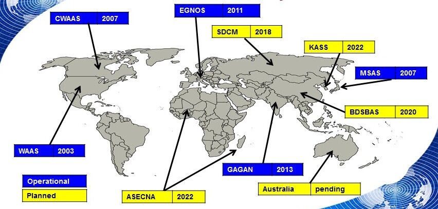
Additional equivalent regional systems, fully interoperable with the existing ones are either in operation (Japan, India, Canada) or in definition or development (Russia, China, South Korea, West Africa and Australia).
Through the LPV-200 procedure, short for ‘localiser performance with vertical guidance 200 feet’, signals from space guide pilots down through any weather down to within just 60 m (200 ft) of the runway, at which point they make visual contact with the ground for a final go/no go landing decision.
EGNOS offers all-weather access to all certified runway approaches – each side of a runway requiring its own, separate, certification – without the need for expensive ground ‘Instrument Landing System’ infrastructure. Satellite-based landing approaches can also be tailored to be smoother and more fuel-efficient.
Smaller airports unable to afford ground instrumentation draw the greatest benefit. Employing EGNOS means they get to operate in all weather conditions.
ESA retains the lead role in the future development of EGNOS, working with Thales Alenia Space and Airbus Defence and Space and their subcontractors to design, develop, deploy, and validate and test the new design elements.
While the current system is solely reliant on GPS, the next generation ‘EGNOS V3’ will combine the use of GPS with Europe’s own Galileo satnav system to boost EGNOS accuracy and reliability still further. It is planned to enter service around 2025.


Access the video