Forecasting weather
It goes without saying that accurate weather forecasts are important for numerous commercial activities such as farming, fishing, transport, energy exploitation and, of course, for generally planning our daily affairs.
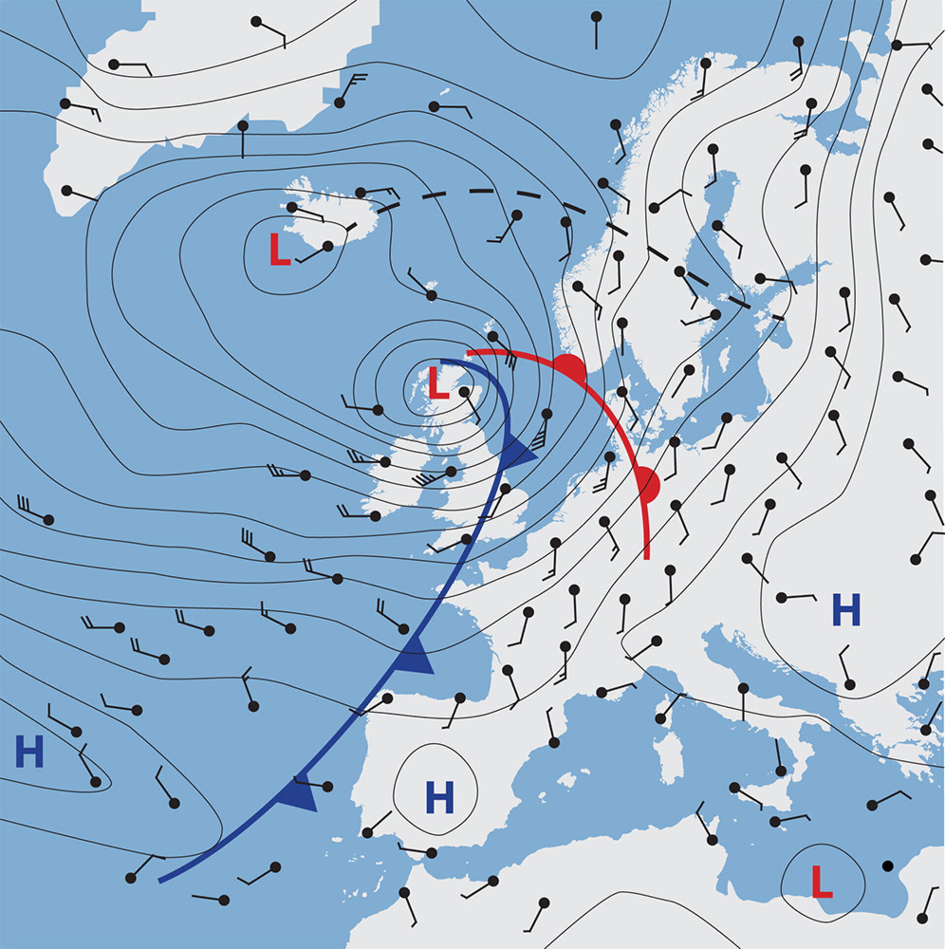
Our daily forecasts rely on numerical weather prediction, which is a process that generates mathematical models of the current weather to predict what the weather will be like in the future, usually over the next few days.
Although weather forecasts have advanced considerably in recent years, Aeolus advanced them even further.
Global wind profiles delivered in near-real time by Aeolus will help improve numerical weather prediction models, which in turn, will therefore help improve forecasts.
It is well known that interactions between wind, temperature and humidity play a key role in determining these atmospheric dynamics, but without the quantity of data that a satellite-based-observation system can provide, these interactions remain difficult to model.
Data from Aeolus improved our understanding of these interactions, which not only led to more accurate predictions, but also to better descriptions of precipitation, humidity, and Hadley circulation in the Tropics.

Access the video
By defining the initial state of the weather with more accuracy, and improving the modelling of wind movements, Aeolus helped create more useful tropical forecasts. This should lead to, among other benefits, better estimates of the position and intensity of tropical cyclones.
In the southern hemisphere's extra-tropics, a dramatic improvement is expected in the short-range forecasting of synoptic events. In the northern hemisphere, there are still cases of forecast failures for events such as strong mid-latitude storms. The percentage of failures have been reduced with the introduction of Aeolus observations. Over the whole globe, small-scale details of intense wind events improved for short-range forecasts because of the earlier detection of their development.
Medium-range forecasts also improved thanks to Aeolus. By providing better definition of the planetary-scale waves and more uniform coverage of Earth, the satellite enabled forecasters to make more accurate predictions for both hemispheres. The greatest improvement, however, was in the extra-tropical regions of the southern hemisphere, where the lack of conventional data coverage made predictions difficult.
Aeolus was also used in air-quality models to improve forecasts of dust and other airborne particles that affect public health.
By recording and monitoring the atmosphere, weather and changes occurring in Earth’s oceans and on land, scientists can identify trends and build complex models to help predict the climate of the future. This information can then be used to reach conclusions concerning, for example, global warming and the effects of pollution – which can ultimately help to define mitigating strategies.
New insight provided by Aeolus on how the wind influences the exchange of heat and moisture between Earth’s surface and the atmosphere is important for understanding climate change.
And, although the mission is now over, the archive of Aeolus data may also be used to help to predict extreme events such as El Niño, which affects weather around the world.