Measuring wind
Like all of ESA’s Earth Explorer missions, Aeolus responded to one of the most urgent Earth-science questions of our time. This novel mission was designed to address the lack of global wind profiles in the Global Observing System.
Established under the auspices of the World Meteorological Organization, the Global Observing System is a coordinated system of methods and facilities for making meteorological and environmental observations on a global scale. Atmospheric measurements are used for weather forecast models worldwide.


Access the video
However, direct global profile measurements of wind fields have been lacking, representing one of the largest deficiencies in the observing system and limiting improvements to numerical weather predictions and climate models.
Most direct observations of the wind come from radiosondes that are launched every day from stations, most of which are in the northern hemisphere. Wind-field information in remote regions, over the oceans, in the tropics and Southern Hemisphere is largely indirect.
Different types of observations currently come from:
Surface data: from land stations, ships and buoys, and also from scatterometer instruments on satellites. They are all single-level data and cannot provide information on atmospheric profiles.
Single-level air data: mainly from aircraft at cruise altitude and cloud-motion winds derived from geostationary satellite imagery. Aircraft observations of wind and temperature are also made during ascent and descent, and are therefore multilevel around airports.
Multilevel air data: mainly from radiosondes, wind profilers and polar-orbiting sounder data. Satellite sounders provide global coverage of radiance measurements, which can only be used indirectly.
Reliable and timely wind profiles from Aeolus will improve our understanding of atmospheric dynamics, transport and cycling of energy, water, aerosols, chemicals and other airborne materials.
The Aeolus mission was built to:
- Measure global wind profiles (along a single line-of-sight) up to an altitude of 30 km
- Measure wind to an accuracy of 1 m/s in the planetary boundary layer (up to an altitude of 2 km)
- Measure wind to an accuracy of 2 m/s in the free troposphere (up to an altitude of 16 km)
- Determine the average wind velocity over 100 km tracks
- Measure 100 wind profiles per hour
However, being such a dynamic and relatively invisible aspect of Earth’s environment, it is extremely difficult to make global measurements of the wind in clear air from space.
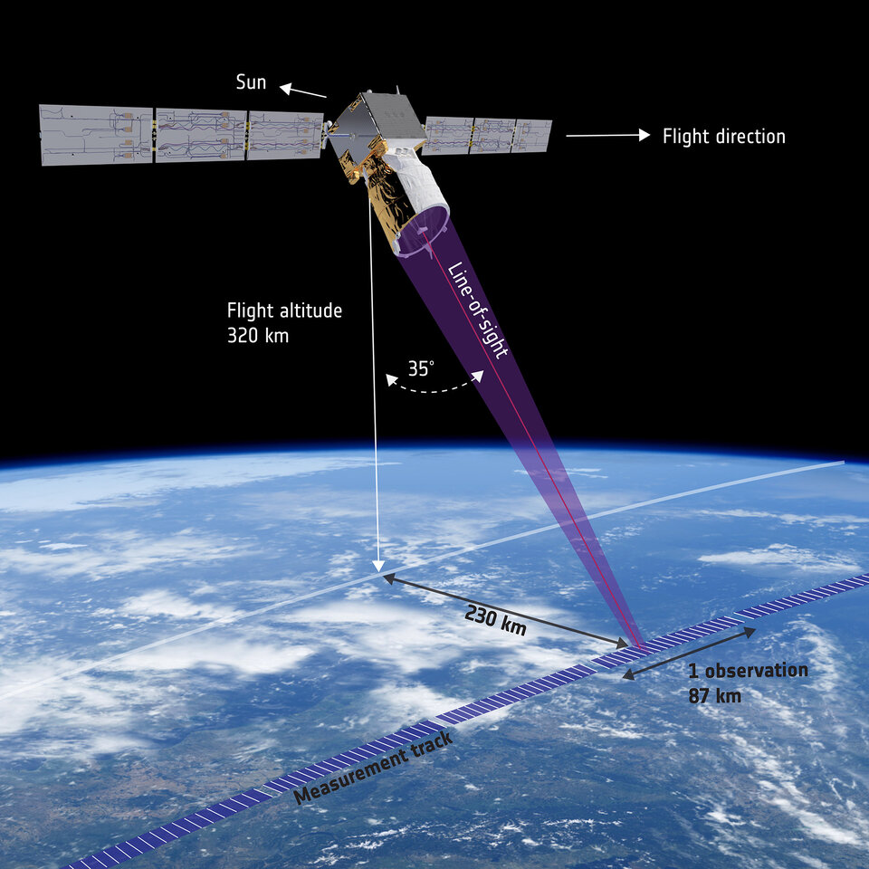
It took many years to develop the technology to do this – nevertheless, Aeolus demonstrated it could profile the world’s winds by probing the atmosphere using a highly sophisticated Doppler wind lidar – a completely new approach to measuring the wind from space.
Its laser fired pulses of ultraviolet light towards Earth’s atmosphere. This light bounced off air molecules and particles such as dust in the atmosphere. The small fraction of light that scattered back towards the satellite was collected by a large telescope.
Through the measurement of the Doppler shifts in the return signals, the horizontal speed of the wind in the lowermost 30 km of the atmosphere was derived, making Aeolus the first satellite mission to deliver profiles of Earth’s wind on a global scale.
The mission, an ESA Earth Explorer research mission, was designed to demonstrate that this technology was feasible – but it did more than that.
Aeolus not only benefited science in terms of contributing to climate research, but its data were used operationally in weather forecasts. Moreover, almost all weather models improved with the assimilation of Aeolus data.
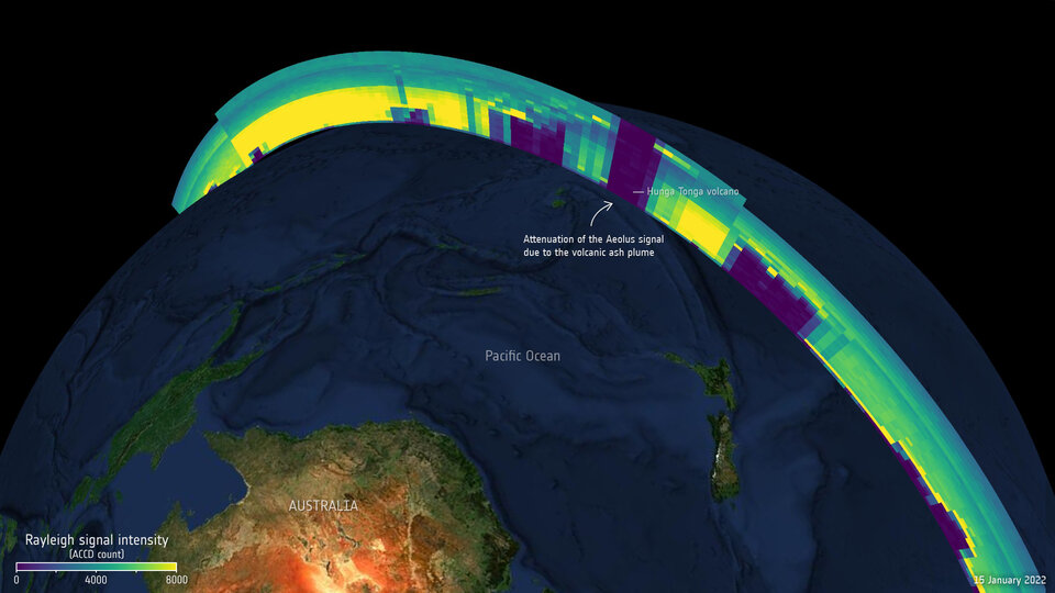
In addition, it was used to track plumes from volcanic eruptions for example, and proved essential during the Covid lockdown when aircraft, which carry weather instruments, were grounded.
A 2022 report by London Economics found that Aeolus also brought real economic benefits – as much as €3.5 billion over the lifetime of the mission.
Back to Aeolus homepage |