
ESA trains next generation of Earth Observation scientists
More than 60 students from 18 European countries gathered at the Universidade Nova de Lisboa in Portugal to attend a six-day advanced training course devoted to exploiting ESA Earth Observation remote sensing data for land applications, such as forestry, fires, floods and water availability.
The course introduced students to remote sensing applications and illustrated the use of specific software tools for exploiting Earth Observation (EO) data from ESA’s ERS and Envisat satellites, Third Party Mission (TPM) satellites and the Explorer satellites.
"This type of training encourages the use and exploration of European information and technology and is important because it is part of the foundation of the training of the future leading European investigators in remote sensing," Marco Painho, Director of the Institute of Statistics and Information Management at Universidade Nova de Lisboa, said.

The course had a particular focus on the theoretical concepts of radar, optical and thermal sensors. Accounting for the different remote sensing backgrounds of the students, the fundamentals of the course were presented in parallel sessions covering both basics and advanced concepts in each field.
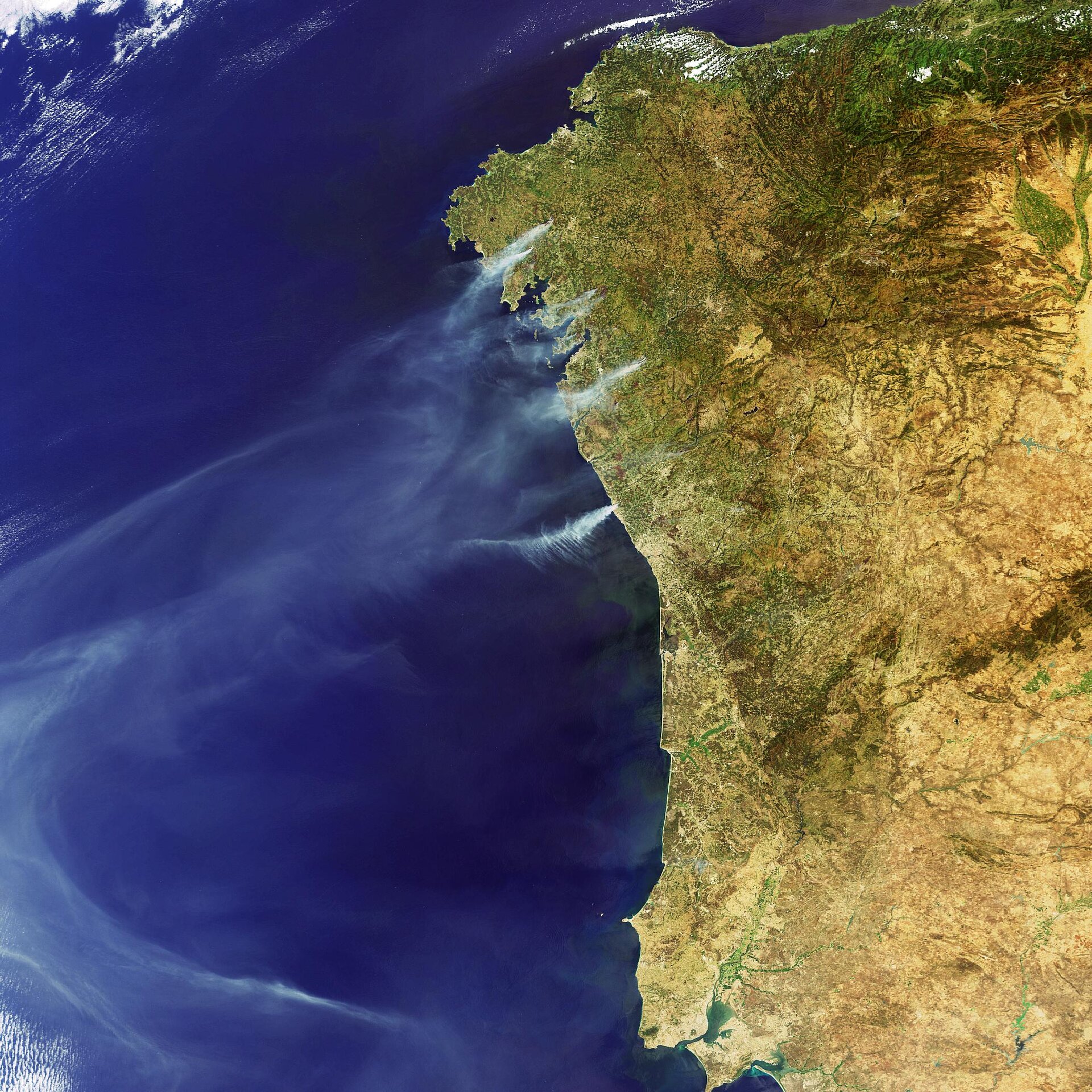
The main applications of land remote sensing, which were addressed through keynote lectures and dedicated hands-on sessions, included land cover and land use classification techniques, forest and crop mapping, forest fire detection and drought monitoring. Advanced techniques such as SAR Interferometry, used for detecting very slight volcanic or tectonic land motion, and SAR Polarimetry, employed to add multi-polarised 'colour' to radar images for enhanced land-cover mapping, were also covered.
"The school made me realise the techniques of EO offer many different possibilities of application. For me it was a demonstration of how we can use the accessible data and tools and how we can build our research activities to make full use of this potential," Agnieszka Izykowska, a student from Polish Space Research Centre, said.

To facilitate the handling and exploitation of ESA and TPM data, ESA provides a number of free software tools, which the students trained interactively with during the course.
"There are a lot of types of software available for processing EO data, but most of these are quite expensive and do not have the tools for adequate information extraction," Prof Mario Caetano said. "This is why I want to acknowledge all the effort ESA has put in the development of software tools for processing EO data, in particular radar data. All these ESA developed software tools are publicly available, free of costs, and I am sure that such a policy will largely increase the research on land remote sensing."

"It is quite important that ESA decided to take a leading role in such necessary training activities, not only organising such a series of advanced courses, but also developing the adequate tools to facilitate the exploitation of the data and making it easier for new users to get access to such exciting technologies," Jose Moreno from University of Valencia said.
Upon completion of the training, the students received two European Credit Transfer and Accumulation System (ECTS) credits by Universidade Nova de Lisboa. ECTS is the basis for comparing the competence and performance of students of higher education across the European Union and other collaborating European countries.
ESA is planning a first advanced training course in atmosphere remote-sensing to be held at University of Oxford, UK, from 15 to 20 September 2008.
Envisat's sensors in spotlight

The Advanced Synthetic Aperture Radar (ASAR) is an imaging radar operating at C-band and capable of observing the Earth's surface day and night, independently of cloud conditions. It features a selectable range of incidence angles, polarisation and modes of operation at different spatial resolution and swath widths.
The Medium Resolution Imaging Spectrometer (MERIS) is an imaging spectrometer that measures the solar radiation reflected by the Earth at a ground spatial resolution of 300 m. It operates in 15 spectral bands in visible and near infra-red and is programmable in width and position. MERIS allows global coverage of the Earth every 3 days.
The Advanced Along Track Scanning Radiometer (AATSR) is an imaging multi-spectral radiometer working in the visible and infra-red spectral domains. It is the most recent in a series of instruments designed primarily to measure Sea Surface Temperature (SST). AATSR data can also be used for a number of land surface, cryosphere and atmospheric applications. AATSR data have a resolution of 1 km at nadir.
