
Earth from Space: Irene’s eye
This week we look at two images taken simultaneously with different Envisat sensors of Hurricane Irene, which struck the US east coast last week.
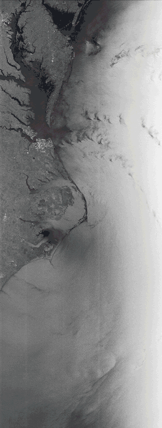
The first black and white image is from Envisat’s radar, covering the coastal areas of North Carolina, Virginia, Maryland and Delaware.
The radar provides an unusual view of a hurricane as it shows the rough ocean surface through the clouds.
In the centre of the image, a dark spot can be seen where the eye of the hurricane passed over North Carolina’s Outer Banks. This area of serene weather at the centre of the hurricane was visible to the radar because calm water provided a smooth surface, appearing darker.
The pattern of the hurricane over the Atlantic Ocean is evident: bright areas correspond to rough seas while the darker areas depict calmer waters. Dark areas may also be caused by heavy rainfall that reduces the radar signal.
The second image is from Envisat’s MERIS instrument and shows the typical spiral cloud pattern of the hurricane.
The two images were captured at 11:15 local time (15:15 GMT) on 27 August. Hurricane Irene wreaked havoc along the coast as it continued north, leaving dozens of people dead and causing billions of dollars in damage.

