
Earth from Space: Vancouver
The Copernicus Sentinel-2 mission takes us over Vancouver – the third largest city in Canada.
Click on the image to explore it in its full 10 m resolution and learn about the features in this stunning landscape.

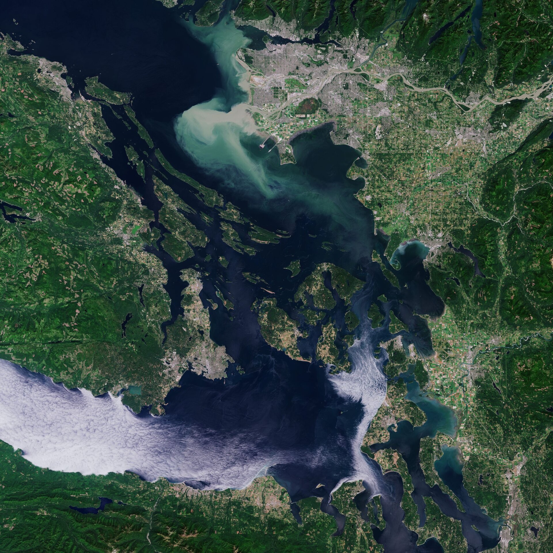
Vancouver, visible at the top of the image, lies between the Burrard Inlet, an arm of the Strait of Georgia, to the north, and the Fraser River delta to the south. Vancouver has the highest population density in Canada, with over 5400 people per square kilometre, making it the fifth-most densely populated city in North America.
In this image, captured on 29 July 2019, an unusually large quantity of sediment can be seen gushing from the Fraser River into the Strait of Georgia. The Fraser River is the longest river within British Columbia rising at Fraser Pass in the Rocky Mountains and flows for over 1300 km before emptying into the strait. The river's annual discharge at its mouth is estimated to be around 3550 cubic metres per second, and is said to discharge around 20 million tonnes of sediment into the ocean.
Several ships and vessels can be easily spotted at the top of the image, in the Burrard Inlet, which separates the city of Vancouver from the slopes of the North Shore Mountains (not visible).
Vancouver Island dominates the left-side of the image. Covering an area of over 31 000 sq km, it is the largest island on the Pacific coast of North America. The island is heavily wooded and mountainous with several peaks of more than 2100 m.
At the bottom of the image, marine stratocumulus clouds can be seen over the Strait of Juan de Fuca, which also marks the international boundary between Canada and the Unites States. These types of cloud formations could be related to the Puget Sound Convergence Zone – a frequent weather phenomena where northwest winds are split by the Olympic Mountains and then re-converge over Puget Sound, visible in the bottom-right of the image.
Copernicus Sentinel-2 is a two-satellite mission. Each satellite carries a high-resolution camera that images Earth’s surface in 13 spectral bands. The mission is mostly used to track changes in the way land is being used and to monitor the health of our vegetation.
This image is also featured on the Earth from Space video programme.

Access the video

