Latin America reaps development dividends with ESA Earth observation training
A joint programme established by the United Nations and the European Space Agency (ESA) to teach advanced remote-sensing technologies is paying off for Earth observation specialists in Chile and other Latin American countries.
The UN/ESA Course Follow-up Programme, established in 1998, is being coordinated by the UN’s Office for Outer Space Affairs (OOSA) in Vienna, and ESA’s ESRIN facility in Frascati, Italy. Its aim is to provide national institutions with follow-on support for remote sensing applications in ongoing sustainable development activities.
In 1999, the programme started to bring together government and university researchers from Bolivia, Argentina and Chile with ESA specialists for a series regional seminars and pilot projects for training in various Earth observation technologies. Much of the training centred on interferometric techniques for synthetic aperture radar, combining two radar images of the same spot of the Earth taken at different times from slightly different angles and analysing the phase differences.
The programme finished in June, but for Carlos Pattillo, the project leader and director of Chile’s Centre for the Study of Remote Sensing and Geographic Information Systems (CPR&SIG), in Santiago, the training provided by ESA Earth scientists will have a lasting regional impact: “The countries who participated in the programme now have in-house technology to use interferometry as a normal technique for other national projects. More importantly, a group of professionals in these countries has up-to-date knowledge to teach these technologies to others.”
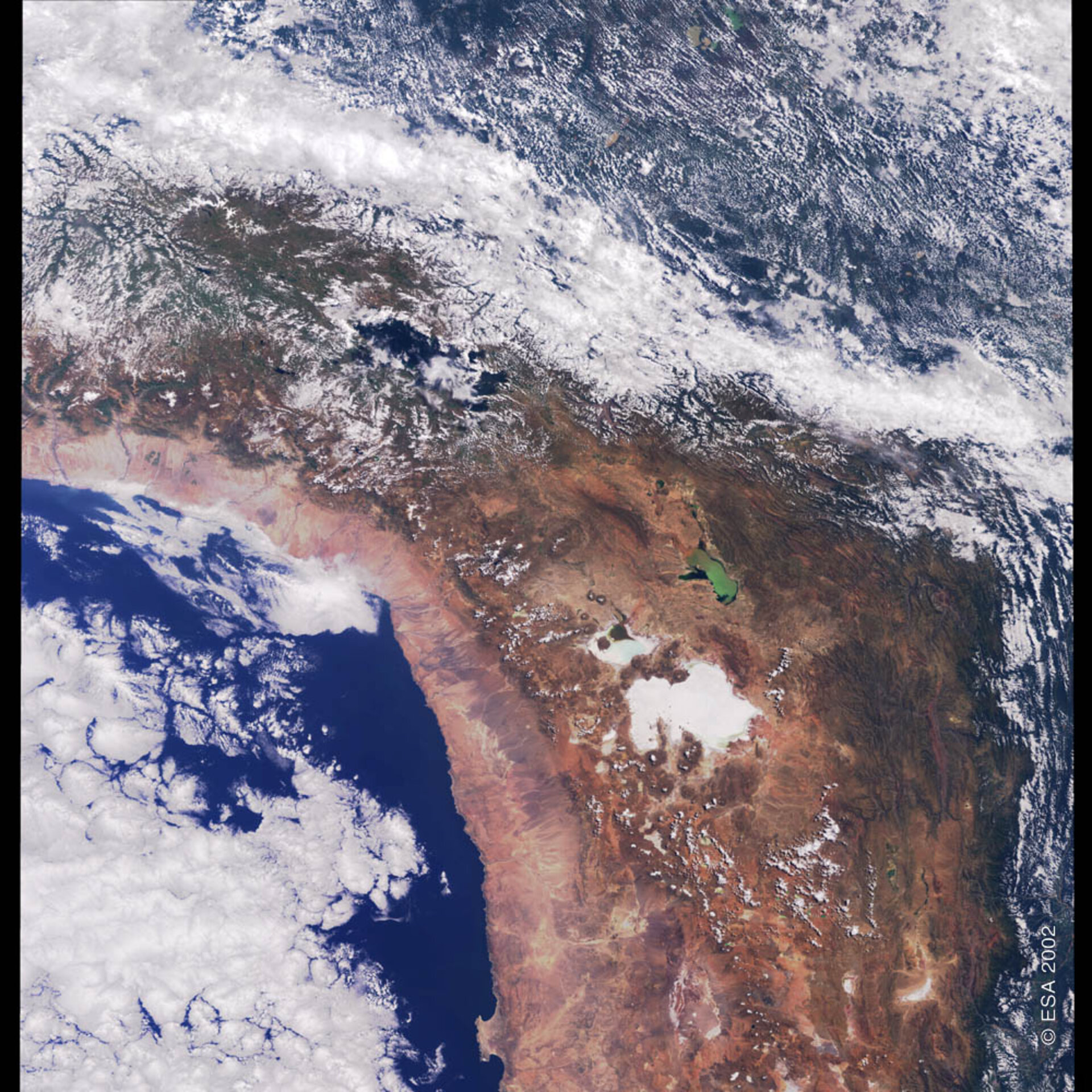
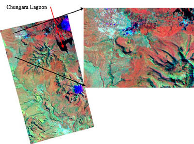
In Chile the training allowed the Antarctic Institute of Chile (INACH) to start a facility for interferometry processing open to scientists in the region who are interested in ice and glacier studies. This takes advantage, Pattillo says, of an agreement signed between ESA and the German Aerospace Centre (DLR) for operations at Chile’s Bernardo O'Higgins Antarctic Base. The base is a receiving station for data from ESA’s ERS satellites and supports German Antarctic research.
“The INACH facility is getting our permanent support to teach scientists interested in using interferometry and to solve any technical problems that they may encounter,” Pattillo said.
University programme goes commercial

The Chilean company grew out of an academic programme at the Catholic Pontifical University in Santiago. At the time the UN/ESA programme was launched in Latin America, Pattillo was helping to create an interdisciplinary programme dedicated to the development of remote-sensing techniques and applications.
Without any computer hardware and software, private and corporate support was solicited to get the program off the ground in 1998. Since then, more than 30 theses have been completed on remote sensing and GIS subjects. Five of those were completed by students who were allowed to participate from other universities.
The university programme also ran a series of technology-transfer projects to help private companies and governmental institutions implement the technologies being taught in the classrooms. These projects were financed by interested organization, and brought the university into closer contact with ESA, France’s Aerospace Remote Sensing Development Group and CNES, the French space agency.
“With their assistance and agreements of understanding and cooperation, we developed a variety of training courses and international seminars,” Pattillo said.
The academic programme, however, hit some organisational snags. Except for paying the salaries of two professionals, the university did not provide any operational funding for the remote-sensing projects; everything had to be financed by the pilot projects, including courses and theses. The university also decided to re-organise these types of programmes, handing over administrative responsibilities to one of the school’s faculties. The programme, renamed the Remote Sensing and GIS Centre, was then hit with a 20 percent budget cut, hindering the capability of the Centre to compete with other enterprises.
Pushed by these administrative problems, Pattillo and his faculty decided to form a private company and formally established CPR&SIG in January with a staff of seven full-time professionals.
Key services
The now-privatised Centre uses Earth observation imagery from a variety of sources:
Landsat Thematic Mapper (TM) and Enhanced Thematic Mapper (ETM) images acquired by the Argentina National Commission on Space Activities and Brazil’s National Institute for Space Research;
SPOT High Resolution Visible (HRV) images from France’s Spot Image;
ERS-1 and- 2 images from ESA’s ESRIN facility in Italy, the Argentine ground station in Cordoba and the O'Higgins Antarctic Base;
Synthetic aperture radar imagery from Canada’s Radarsat International and the Canada Centre for Remote Sensing;
IKONOS images;
- Aerial photography.
The company’s main lines of imagery-based services are natural-resources assessment and monitoring using ortho-rectified satellite images, imagery that has been processed to remove angles and other image distortions. The company also offers integrated solutions combining satellite imagery and geographical information systems (GIS) - information derived from satellite images that is normalized and managed together with other sources of information to provide end users with a system that can be easily updated and controlled.
Environmental applications for the Centre’s services include: forest fire detection and evaluation; analysis of soil erosion after forest clear cutting; studies of water sediment and eutrophication, the process by which nutrients dissolve in water and artificially stimulate plant growth; and, environmental baseline studies for urban planning and civil infrastructure.
Recent Projects

Among some recent work conducted by the Centre has been the "Environmental Facets" project, performed for Chilean Ministry of Public Works. According to Pattillo, it involved developing consistent zoning regulations in the country that would consider the impact of the environment on civil infrastructure and, conversely, the impact of a civil infrastructure on the local ecosystems. In this project, satellite images from Landsat and SPOT were used to assess vegetation types and the protection factor of soils in potential erosion problems.
A three-year-long project has been the study of dunes over the coastal zone of central Chile. In this one, SPOT images was used to assess environmental changes, including the loss of vegetation and the reactivation of sand dunes, caused by industry and urban growth in fragile areas formed by old dunes plains. This project has been financed by Chile’s National Science Fund with the cooperation of France’s National Centre for Scientific Research and a research project with the University of Nantes. CPR&SIG is currently working on a follow-up program to use imagery from ESA’s ERS and Envisat satellites to analyse the physical characteristics of the dunes environments.
Other projects include the use of Landsat images for chlorophyll assessment in bodies of water, pollution of coastal zones by the iron industry in northern Chile, Radarsat images for evaluating the environmental condition of rangelands in southern Chile, and ERS interferometry for updating maps and generating digital elevation models.
What needs to be done
Although Pattillo has no doubts about the positive impact such projects have had both in Chile and in other nearby countries, much more needs to be accomplished, he said.
“A lot of pilot projects have been done, but there are still no operational projects underway due mainly to the lack of a critical mass of trained professionals,” Pattillo explained.
Pattillo outlined his intent to focus international participation on carrying out one or two operational projects, and in forming permanent training facilities in each Latin American country. He said that the Latin American Remote Sensing Society (SELPER), a regional association of imagery specialists of which ESA is a special member, has been promoting actively the use of satellite remote sensing with assistance from ESA. Pattillo, who serves as SELPER’s representative in Chile, noted that the association was formed in 1981 and currently has chapters in every Latin American country.
“Through SELPER-Chile, we have encouraged Chilean professionals to use remote sensing and there are nearly 90 SELPER associates here alone that could benefit from a permanent training facility,” Pattillo said. “Once again, ESA's help will be necessary to keep focusing the activities in this direction. Our company will continue its training activities, but we think that this effort should be undertaken in a bigger scale, and that means at a national level with formal resources from the government.”