About A-DCS
The Advanced Data Collection System (A-DCS), also known as ARGOS, is to provide a worldwide in-situ environmental data collection and Doppler-derived location service with the basic objective of studying and protecting the Earth's environment. The A-DCS is currently jointly operated by NOAA and CNES. However, with the instrument installed on the MetOp series, EUMETSAT will become the third agency to operate the system.
A-DCS collects data from platform transmitters (PTTs) located on land and ocean in UHF frequency. Over 5000 environmental platforms are located around the world. Marine PTTs located on buoys transmit oceanographic data and PTTs on ships transmit weather and oceanographic data. Land-based PTTs provided meteorological and hydrological data and those on balloons provide atmospheric information.
Another important A-DCS application is the tracking of animals using mini- and micro-DCPs (Data Collection Platforms) – this is especially useful in the study of migratory species.
The A-DCS instrument collects and processes data for immediate transmission to the ground and for subsequent transmission from the satellite to high-latitude ground stations at each orbit.
Two global processing and data distribution centres are located in Toulouse, France and Largo, Maryland, USA. They receive and process raw data from EUMETSAT and distribute the processed data to the users.
A-DCS signal
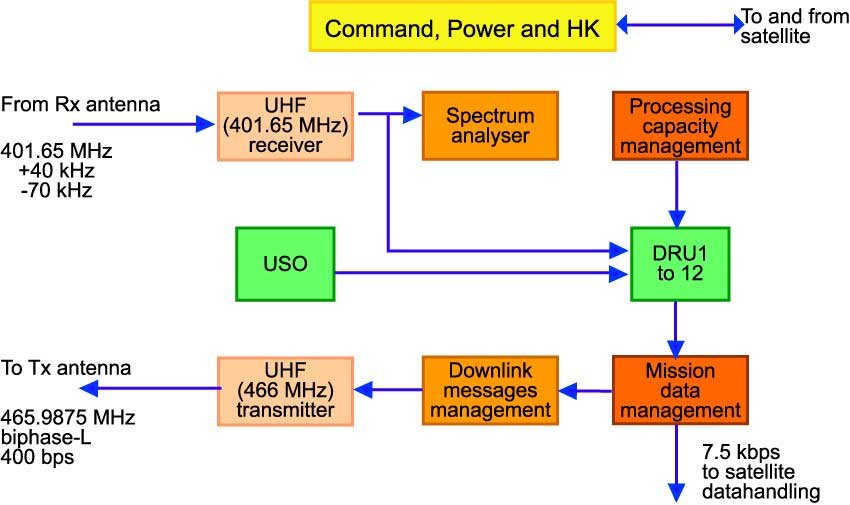
Environmental platforms transmit data to the Advanced Data Collection System (A-DCS) at a carrier frequency around 401.650 MHz, digital modulation format at 400 bps and 4800 bps. The A-DCS demodulates this signal and determines the carrier frequency and relative time of each transmission. This processing capacity management subsystem optimises the operation of a software equivalent to twelve stand alone Data Recovery Units allowing up to twelve messages to be processed in parallel. The mission data is processed, formatted, and transferred to the satellite for real-time or for later transmission to ground. A dedicated UHF transmitter (TXU) is used to transmit downlink small messages to the users beacons fitted with a UHF receiver. These messages are sent by the users to their beacons or autonomously by the instrument for acknowledging some of the beacon uplink messages.