Modelling tides in the Arctic Ocean
We are all aware of the ebb and flow of the tide every day, but understanding tidal flow is important for a range of maritime activities and environmental monitoring, such as search and rescue operations, shipping routes and coastal erosion. The Arctic Ocean tides are particularly difficult to understand, but a new tidal model produced using ESA satellite data may shed some light on what is happening in this remote area.
In many areas of the ocean, direct in situ measurements of ocean tides are rare. This means that tidal models need to be developed to fill in the gaps in observations.
Owing to its location, the Arctic Ocean proves more difficult because of the scarcity of in situ observations, the frequent presence of sea ice and poorly-documented bathymetry. The bathymetry, or the depth and shape of the ocean floor, is crucial for studying ocean dynamics and for ship safety.
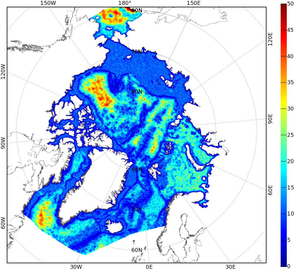
Arctide2017 is a high-resolution tidal atlas of the Arctic Ocean. Developed by NOVELTIS, DTU Space and LEGOS, it combines altimeter data from ESA’s Envisat and CryoSat satellites into the most complete dataset used in the Arctic region to estimate tidal information.
Satellite altimetry missions are often used to estimate ocean tide information, however this technique requires a long-time series of satellite data to derive accurate tidal estimates – usually more than 10 years.
CryoSat is traditionally used to determine changes in the thickness of ice, but its radar altimeter can also measure changes in sea level. Moreover, thanks to its unusually high-inclination orbit that takes it close to the poles, ESA’s CryoSat mission can also provide tidal information in regions that are not sampled by other satellite altimetry missions.
Also the number of altimeter observations increases towards the poles due to how the satellites circle Earth. This allows scientists to estimate tidal information over shorter periods of time, particularly in the Arctic Ocean.
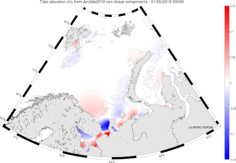
The Arctide2017 is based on modelling with data assimilation for the main linear tidal components, however non-linear tidal components have not yet been produced – until now.

Tidal information extracted from satellite altimetry observations are generally reliable only for ‘linear tides,’ which describe the tide as the simple result of the gravitational pull of the Moon and Sun.
However, other factors influence the tides such as bathymetry and coastlines, generating ‘non-linear’ tidal components. In shallower waters, a significant part of the tidal signal is due to these ‘non-linear’ components – causing very complex tides. One way of estimating these tides is through tidal modelling.
Mathilde Cancet, a scientific engineer at NOVELTIS comments, “Thanks to the model’s grid resolution and the specific processing of the assimilated altimetry observations, the Arctide2017 regional tide atlas outperforms the concurrent regional and global models in most regions of the Arctic Ocean.”
The Arctide tidal model will benefit satellite altimetry sea level measurements in the Arctic Ocean, as well as various end-users such as modellers and other stakeholders in the maritime industry.”
This work was carried out in within the CryoSat Plus for Ocean (CP4O) project funded by ESA.