Water mission versatility
While ESA’s SMOS satellite continues to provide key information on soil moisture and ocean salinity for a better understanding of the water cycle, Living Planet Symposium participants in Edinburgh today heard how the mission is also set to improve weather forecasts.
Carrying a novel radiometer that works at 1400–1427 MHz, SMOS captures images of ‘brightness temperature’ to derive information on soil moisture and ocean salinity.
Integrating these accurate near-realtime observations into the European Centre for Medium-Range Weather Forecasts’ (ECMWF) system is helping to improve air temperature and humidity forecasts.
This is particularly true for the northern hemisphere during summer months – there is more land than in the southern hemisphere and soil moisture dynamics are higher.
In addition, the inclusion of SMOS observations are helping to improve the prediction of rain.
SMOS was built primarily to deliver important information for scientific research, but this example shows how its data are now also being used operationally, and for something we all rely on – weather forecasts.
It has, however, been no mean feat incorporating SMOS data into the forecasting system.

ESA’s Matthias Drusch said, “Anticipating the introduction of SMOS near-realtime observations into the most powerful data assimilation and forecasting system on Earth is a project that has taken 10 years.
“It has meant major revisions of the data-handling procedures, task scheduling and the implementation of a new dedicated data assimilation system.
“Thanks to our cooperation with ECMWF, all these efforts have been very worthwhile as the results offer true socio-economic value.”
Initial research at ECMWF has also indicated that the SMOS observations can have a positive effect on the monitoring of the net ecosystem exchange of carbon dioxide and, subsequently, the terrestrial carbon cycle.
Soil moisture observations from SMOS mission have also demonstrated their value for flood prediction.
For example, just prior to torrential rains that hit central Europe in May, which led to catastrophic floods, observations from SMOS had shown record levels of soil moisture.


Access the video
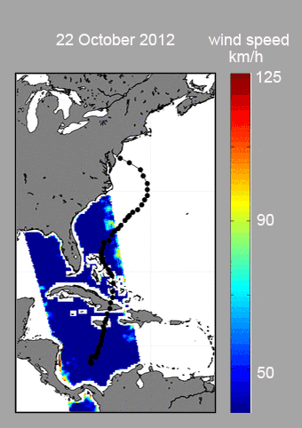
Over the oceans, SMOS is not only providing essential information on the saltiness of surface waters, which are leading to a better knowledge of ocean circulation, but the mission also has the potential to help improve hurricane forecasts.
“SMOS observations of brightness temperature is a totally new source of information for tracking hurricanes,” said Nicolas Reul from Ifremer.
“We can’t actually use observations from under hurricanes to measure ocean salinity because of the effect that surface roughness and foam have on the brightness temperature signal.
“However, we can make use of this effect to estimate wind speed just above the ocean surface.
“This could potentially lead to better forecasts of hurricane strength and direction, thereby helping to make better predictions of where a hurricane may make landfall, which of course is what people want to know.”
SMOS took centre stage today at the Living Planet Symposium, shining as a truly versatile mission.
It is fulfilling its scientific objectives, but offering much more. Along with these examples, this multifunctional mission is also providing new information on sea ice and permafrost.