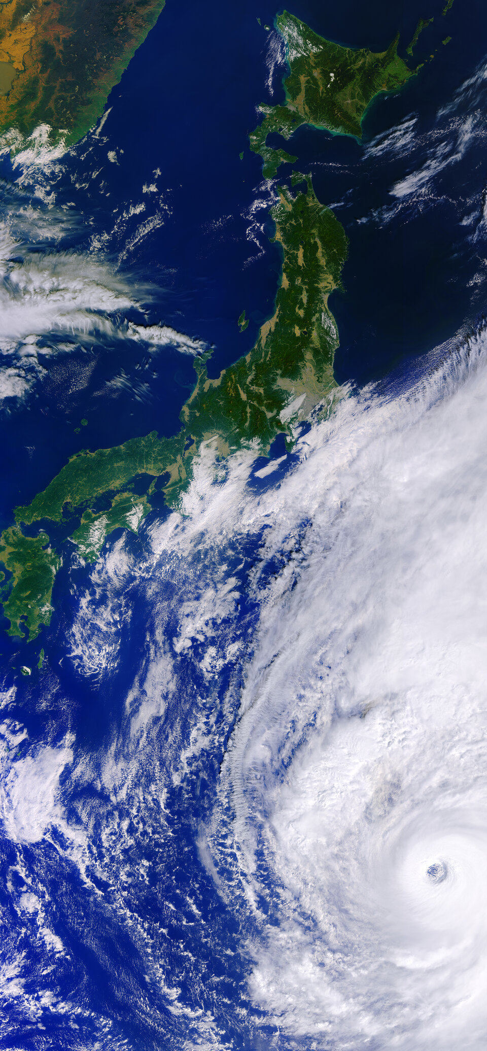
Tracking Typhoon Hagibis from space
Hagibis was the biggest typhoon to hit Japan in decades. With extreme events like this likely to increase in number and in severity as a consequence of climate change, satellites are playing an increasingly important role in understanding and tracking huge storms.
Different satellites carry different instruments that can provide a wealth of complementary information to understand and to respond to a single event.
After making landfall on 12 October 2019 on Shizuoka Prefecture’s Izu Peninsula, Hagibis brought record-breaking rainfall, triggered mudslides and caused severe flooding.
While the storm was still over the ocean, both Copernicus Sentinel-1 and ESA’s SMOS missions were used to track what was going on within and beneath the storm at the sea surface, and Copernicus Sentinel-3 imaged from above.

Copernicus Sentinel-1
The Copernicus Sentinel-1 mission carries an advanced radar instrument to provide an all-weather, day-and-night supply of imagery of Earth’s surface. Its ability to ‘see’ through cloud and rain and in pitch darkness makes it particularly useful to measure the ocean surface wind speed of tropical cyclones.
As the radar signal penetrates the clouds, the pattern created by the cyclone on the sea surface – known as the ‘roughness’ – can be characterised. This allows the ocean surface wind speed to be calculated. This is possible thanks to the Sentinel-1 image dual polarization combination.
The high resolution of Sentinel-1 provides an unprecedented detailed insight of the cyclone inner core structure, in particular the eye’s diameter, the radius of maximum winds and the maximum wind speed.

In the case of Typhoon Hagibis, on 8 October the Sentinel-1 satellite measured the eye’s diameter at the sea surface as 20 km, the radius of maximum wind speed was 25 km and the maximum wind speed was greater than 60 m/s.
These data are valuable for the Satellite Hurricane Observation Campaign (SHOC), which collect satellite observations to provide a synoptic view of hurricane development and evolution. SHOC involves CLS (Collecte Localisation Satellites), IFREMER (French Research Institute for Exploitation of the Sea) and Météo-France.
Alexis Mouche from IFREMER states, “The synthetic aperture radar is the only sensor that can characterise extreme winds, greater than 70 m/s, at a high resolution. These measurements complement existing data, helping scientists to better understand the physical mechanisms of these phenomena.
"This could also lead to a more accurate analysis of tropical cyclones, particularly their ocean surface wind direction and intensity, and can therefore open possibilities in improving hurricane forecasting."

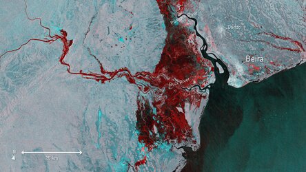
As well as this, images from before and after a flood offer information on the extent of inundation and can be used to help authorities to assess damage to infrastructure and environment. The Copernicus Sentinel-1 image shows the extent of flooding in red near the cities of Sendai and Ishinomaki on 12 October.
SMOS
Although originally intended to measure soil moisture and ocean salinity, ESA’s Soil Moisture and Ocean Salinity (SMOS) mission can estimate the wind speed at the sea surface under tropical cyclones.

The satellite carries a novel microwave sensor to capture images of ‘brightness temperature’. These images correspond to radiation emitted from Earth’s surface, which are usually used to collect information on soil moisture and ocean salinity.
Strong winds over oceans whip up waves, which in turn affect the microwave radiation from the surface. This means that although strong storms make it difficult to measure salinity, the changes in radiation can be linked to the strength of the wind over the sea.
While Sentinel-1 provides high resolution information over limited areas, SMOS offers the advantage of a very wide swath providing regular coverage of the entire ocean. These different data complement each other.
John Knaff, from the NOAA Center for Satellite Applications and Research, says, “Wind field estimates of tropical storms, such as Typhoon Hagibis, are extremely difficult to produce. Over the last few years, satellite observations have become extremely valuable as they are able to estimate surface winds of cyclones.”
“As track and intensity forecasting errors have become fewer, accurate estimates of the extent and structure of tropical wind field is becoming a higher priority in the tropical cyclone forecasting process. These new capabilities such as wind speed estimates from satellite data are becoming more available to operations, and allow for finer-scale temporal and spatial estimates of tropical cyclone surface wind structures.”
Nicolas Reul, a scientist at IFREMER says, "The complementing measurements we get from Sentinel-1 and SMOS provide an unprecedented source of information about the surface wind speed structure from the eyewall to the outer core of the high wind region of tropical cyclones. This will help us to better understand the physical mechanisms of these phenomena, and already improves hurricane forecast and warning systems."
International Charter Space and Major Disasters
The typhoon also triggered an activation on the International Charter Space and Major Disasters, by the Asian Disaster Reduction Center. Using observations from several satellites, the service provides information for emergency response and provides on-demand mapping to help civil protection authorities and the international humanitarian community in the face of major emergencies. In this case, Copernicus Sentinel-1 was used within the activation.