"To make a business out of Earth Observation, you have to keep contact with science"… Interview with Heike Bach
Heike Bach is one of a select group of scientists taking Earth Observation techniques out of the research lab and applying them to the real world.
A decade ago she founded the company VISTA – Remote Sensing Applications in Geosciences, with the motivation of transferring scientific results in the field of Earth Observation into hydrological and agricultural applications.
Author of more than 60 journal and conference research papers, Bach currently serves as Executive Director of VISTA and is managing a large number of activities including operational flood forecasting and agricultural monitoring projects.
Flood forecasting and agricultural monitoring seem quite separate fields – what is the link between them?
The link between them is water - my background being a hydrologist. Flood forecasting requires accurate hydrological models, so you have to understand the whole water cycle to predict when water is going to appear on the surface and produce floods.
Plants meanwhile need water very urgently. They transpire it through their leaves. By using satellite data we can tell the water content and health of plant leaves, based on their spectral characteristics, and on the other hand we can measure soil moisture to help estimate the capacity of the soil to absorb rainfall or whether there will be surface run-off.
How did you get active in this field?
Hydrology - the science of water - fascinated me from the early beginning because of its relevance both for people and the environment. It is a very broad subject which integrates knowledge on soil, plants, meteorology and engineering.
My interest in remote sensing started at university. In my department there was a strong group in remote sensing in the 1980s, one of the first groups in Germany, exploiting data from the Landsat Thematic Mapper among other satellites.
From the beginning of our research we treated remote sensing data as quantitative data, meaning a result of a physical measurement and expressible in numbers. So already at that time we were working at atmospheric correction of Landsat data, and the retrieval of parameters correlated to biophysical meanings, such as canopy reflectance, plant biomass and leaf area index. In 1989 we started working with hyperspectral images.
What does 'hyperspectral' mean?
Hyperspectral satellite sensors are like having spectrometers in space. They don't obtain images in the same way as you get images from Landsat or normal optical satellites. Instead what you get is the reflected light in various spectral bands extending beyond the range of the human eye.
This combination of spectral bands can for example enable analysis of the different contents of the atmosphere - permitting researchers to correct for atmospheric effects – as well as the mineral contents of soil, bio-chemical constituents like chlorophyll in plants and in water and also biophysical properties such as biomass and leaf area index. There is an opportunity for added information all along the spectral reflectance curve, whereas with conventional images you mostly just interpret what is depicted in the image.
Hyperspectral sensors are an improvement on their multispectral counterparts because they use many more spectral bands and so yield more information.

Back in 1989-1990 we were using airborne hyperspectral imagers to investigate what they could tell us, but today we have two such imagers in orbit – the Hyperion sensor aboard the US EO-1 spacecraft, which is comparatively 'noisy', and ESA's Proba satellite with the Compact High Resolution Imaging Spectrometer (CHRIS) sensor - the first very well-working orbital sensor of its type.
What are the advantages of CHRIS/Proba?
Besides the atmospheric, biochemical and biophysical parameters I mentioned that can be measured with CHRIS's hyperspectral capability, Proba additionally performs a roll as it passes a target, to acquire images at five different angles.
This multi-angular capability with high spatial resolution is absolutely new and has never happened before from space. It enables the measurement of the behaviour of the reflectance at different angles – what we call the Bidirectional Reflectance Distribution Function (BRDF) – which is very different and characteristic for each species and for each time of year when the plants are developing.
BRDF is extremely difficult to measure from an aircraft. The long distance makes measurements much easier. So CHRIS gives information on physical parameters such as the canopy structure and leaf angle that is completely unprecedented.
I was involved in planning a follow-on hyperspectral multi-angular Earth Explorer mission called SPECTRA, which was not selected by ESA. We are now proposing a hyperspectral sensor called ENMAP, still in selection in Germany, to be decided at the end of the year.

In the meantime, the different angles acquired by CHRIS present ESA with an ideal opportunity: this hasn't been done yet but I would like to see a database put together of PROBA acquisitions over test sites all over the globe. This database could enable the parameterisation of the BRDF function of the worldwide land surface and improve our understanding of the radiative transfer of the canopy - helping in turn to improve the accuracy of scientists' climate models.
What sort of projects does your company, VISTA, work on?
I formed VISTA ten years ago – in terms of what we do, we have a rough split down the middle between the 50% of projects that are more science-based, where ESA and other organisations are sponsoring, and the other 50% are from clients for various operational services, using all kind of satellite as well as airborne sensors.
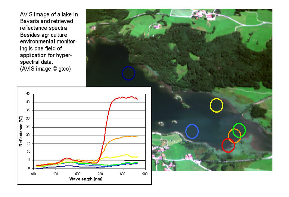
We have a very good collaboration with Professor Wolfram Mauser and his remote sensing unit at the University of Munich. I think it's important that if you want to make a business out of Earth Observation data you have to keep contact with science and make some new developments – not just relying on the same tools that are available to everyone. For example, we recently installed the AVIS imaging spectrometer in the ultralight aircraft of the University of Munich. This allows us to provide our customers with low cost hyperspectral data.
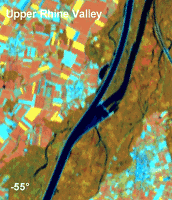
Two regional flood forecasting centres in Germany get our data – for the Upper Rhine and Mosel Rivers – and we also are participating in a big national research programme going on in the area of precision agriculture. We are also involved in various other activities, both inside and outside Europe.
How can Earth Observation improve our knowledge of floods?
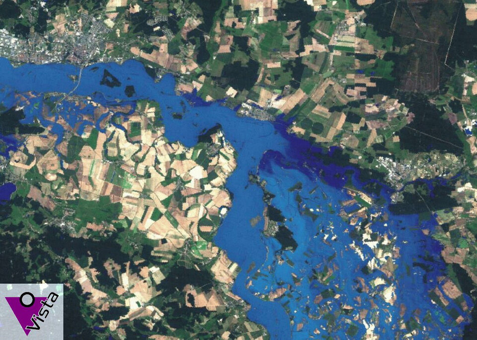
Flooding is the world's most damaging natural catastrophe, costing hundreds of millions of euro in damages annually. This makes it of significant interest for insurance companies: VISTA has recently completed an analysis of the Elbe flood of 2002, where we followed the entire event to help with risk assessment for the reinsurance sector.

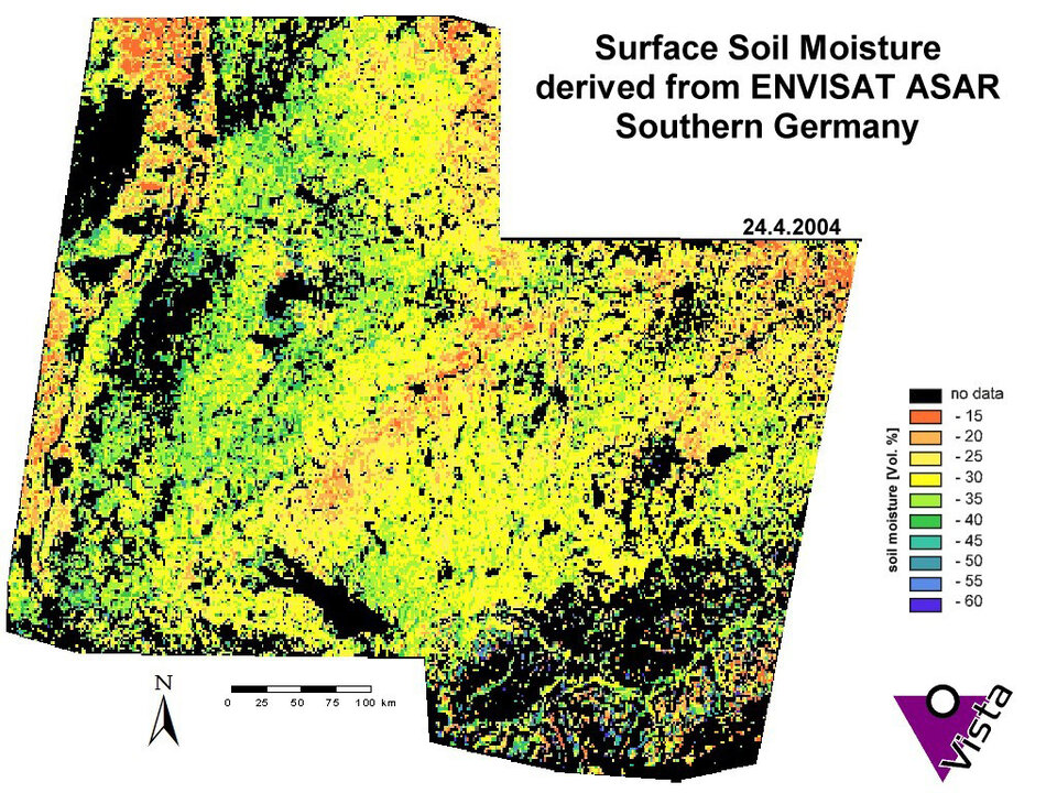
Flood monitoring – tracking an actual flood event taking place - is comparatively straightforward because you can use a combination of optical and microwave data to see the water sitting on top of the soil – the two work well in combination, with microwaves able to penetrate cloud cover, and also give information not just on the top of the ground but a little deeper.
Flood forecasting is more demanding. Microwave data in particular can measure actual soil moisture to help assess how close it is to being waterlogged, likely to result in run-off. The combination of optical and microwave measurements can monitor snow cover and snow melt.
The challenging part is how to properly assimilate this data into the complex flood and hydrological models used for forecasting. The information retrieved from each sensor has to have its reliability assessed, so that an uncertainty estimate can be considered in the model. This is something that has to be worked on in general – not just for flood models, but agricultural yield forecast models, carbon models… it is the same across many different Earth Observation applications.
The two flood forecast centres that employ our data apply their own hydrological models. We provide the Earth Observation information for them to make their own forecasts. During the winter that means daily updates for a given watershed, because the underlying hydrology is very dynamic and can change significantly from day to day.
How do you employ Earth Observation in the field of agriculture?
Right now in Germany there is a big precision agriculture research programme going on called PreAgro. And VISTA is responsible for remote sensing applications within it, working on two huge test farms in East and North Germany. This is a shared cost activity, meaning that 50% of funding comes from the German government and 50% is paid by the company. We are participating because we believe precision agriculture will be important in the long-term future.
The basic idea behind it is to reduce the impact of agricultural management on the environment by applying fertilisers, fungicides and pesticides only in the regions it is really needed, on an adaptive basis. This is good for the environment – especially groundwater – and also saves the farmer money. The accuracy should be sufficient that chemical application can be reduced with no disadvantage for the health of individual plants or the overall yield.
We are making a strong use of hyperspectral data, CHRIS/Proba images as well, but for operational applications we use the airborne AVIS sensor I mentioned before. The Earth Observation updates needed for agricultural monitoring are less frequent than for flood forecasting – with new images acquired every two weeks to one month. The reason is again data assimilation – it is not the images alone that help us, but the information retrieved from it.
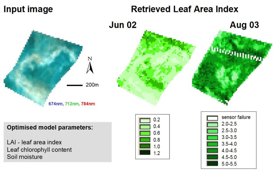
We do not directly know the grain yield – we cannot count individual grains! However we have a model for yield estimates, and we can use the information Earth Observation gives us and integrate it in the model. Then we can simulate the grain yield and plant biomass for every day combined with actual weather inputs. Every four weeks or less new satellite images enable us to update the model parameters.
Applying Earth Observation to precision agriculture could potentially also be helpful to satisfy the growing amount of product documentation farmers need to fulfil, and with GPS-based harvesting machines increasing in popularity, such GPS instruments could then get added inputs from Earth Observation. There is also potential in terms of assessing quality parameters but we are still learning if that is possible.
How is providing an operational service for customers different from doing science?
The big difference is that the customer just tells you their problem and you have to find a way to solve it. They don't care whether it is with optical or microwave imagery, an airborne sensor or satellite sensor. They just want the final high quality product to provide them the information they need, without wanting to know all the background behind it.
Programmes like ESA and the European Commission's Global Monitoring for Environment and Security (GMES) are very useful for transferring scientific methodologies into practical procedures working on a routine basis. It is important that such procedures get upgraded to provide the best operational information to users.
It takes good examples and good experiences before a customer feels this really works, EO provides relevant information and can be relied on. It can take a long collaboration with a customer before they say this year they want to extend this service from this region to other regions – it takes time and hard work to gain trust.