Iris for safer air travel
Aviation accidents sometimes highlight how much we still rely on old-fashioned radio contact by pilots and vulnerable tracking systems. But satellites are set to change sky safety, thanks to international collaboration.
ESA’s Iris programme is looking to satellites to make aviation safer through modern communications. Worldwide digital data links via satellite, offering much higher capacity, will become the standard for cockpit crews, with voice communications kept as backup.
Iris is part of a much broader push to modernise how air traffic is managed in collaboration with the Single European Sky effort of the European Commission, Eurocontrol, airport operators, air navigation providers and aerospace companies.

Modernisation on this scale demands a long-term stepped approach but it promises to boost efficiency, capacity and performance. Iris is divided into two phases, in line with Europe’s master plan for managing future air traffic.
First, the Iris Precursor service will provide air–ground communications for initial 4D flight path control by 2018, pinpointing an aircraft in four dimensions: latitude, longitude, altitude and time.
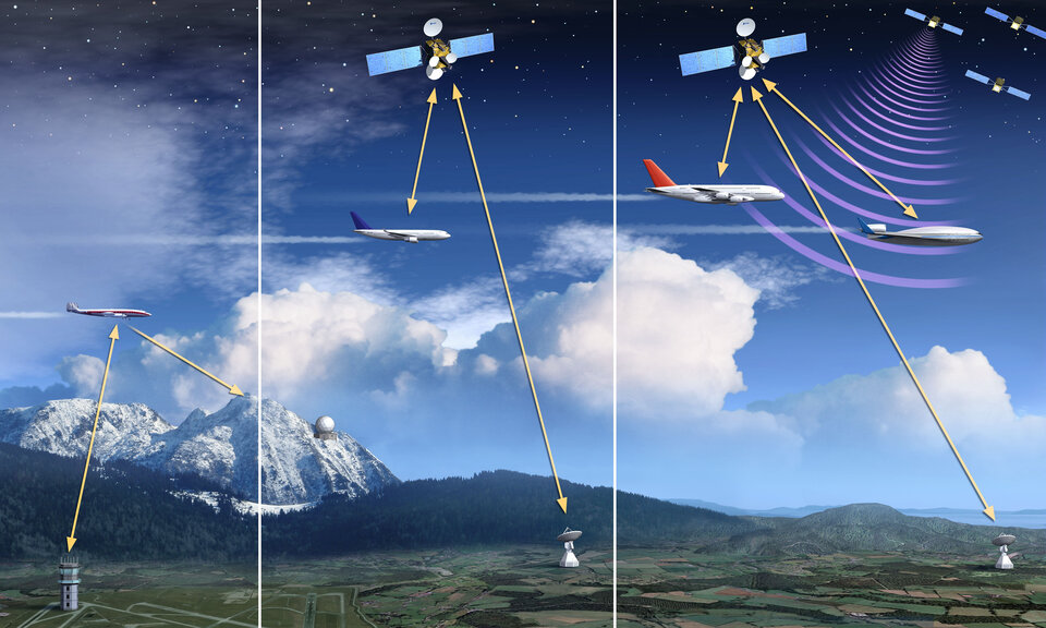
Second, by 2028, the Iris long-term service will enable full 4D management over airspaces across the globe and the data link will be the primary means of communications between controllers and cockpit crews.
Controlling flight paths with 4D is safer and more reliable. To help achieve this goal, ESA is developing a new global standard for satcoms that can be adopted worldwide, and is designing infrastructure to make this service available in Europe.
Lower costs and emissions, higher capacity and safety

To meet safety regulations, aircraft in European airspace fly an extra 42 km on average than they would on an optimal route, incurring unnecessary costs and carbon dioxide emissions. 4D paths will enable precise tracking of flights and more efficient management of traffic.
A key benefit of 4D is that it allows rapid rerouting, meaning fewer flight cancellations and delays, and safer air travel – possible partly because all aircraft will be continuously monitored and locations periodically reported to control centres.
Airlines have accepted the need to switch to digital services, and some satellite services are already in use over ocean airspace.
The changes will take some time because manufacturing schedules for aircraft are set years in advance. Existing planes require modifications to install the new hardware, and affordability requires that costs are kept to a minimum.
“This programme will bring essential improvements to the safety of air travel as well as vast economic benefits,” notes Magali Vaissiere, ESA’s Director of Telecommunications and Integrated Applications. “We can only do it if we join forces, and are ready to tackle this challenge step by step.”