ESA's PREMFIRE project to fight forest fires
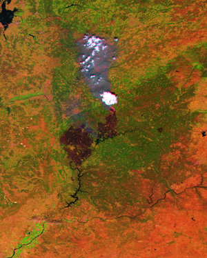
Forest fires have an important environmental and economic impact in southern European countries such as Portugal. Every year over 50 000 hectares of forest are burnt in Portugal. Although many countries have a fire-fighting system for prevention, detection and combat of fires, they lack of an operational fire prevention system based on the daily monitoring of fire risk. The ESA project PREMFIRE will implement a demonstration system for fire-risk assessment that can be easily used by the civil protection staff or other fire prevention services. It will deliver geographical maps directly to fire fighters in the field. These maps will include Earth observation data from, for example ESA's ERS satellite combined with fire-risk maps containing information such as topography, fire history and land use. The maps will be made available in the field to the civil protection authorities on palmtop field terminals via wireless technology and will be updated in real time as soon as new data is available. This image is from a fire at Balocas in Portugal, 9 September 2001.