About ESA
The European Space Agency (ESA) is Europe’s gateway to space. Its mission is to shape the development of Europe’s space capability and ensure that investment in space continues to deliver benefits to the citizens of Europe and the world.
Highlights


Latest


Space in Member States
Find out more about space activities in our 23 Member States, and understand how ESA works together with their national agencies, institutions and organisations.
 Germany
 Austria
 Belgium
 Denmark
 Spain
Spain
 Estonia
 Finland
 France
 Greece
 Hungary
 Ireland
 Italy
Italy
 Luxembourg
 Norway
 The Netherlands
 Poland
 Portugal
 Czechia
 Romania
 United Kingdom
 Slovenia
 Sweden
 Switzerland
Science & Exploration
Exploring our Solar System and unlocking the secrets of the Universe
Go to topicAstronauts


Latest


Enabling & Support
Making space accessible and developing the technologies for the future
Go to topicLatest


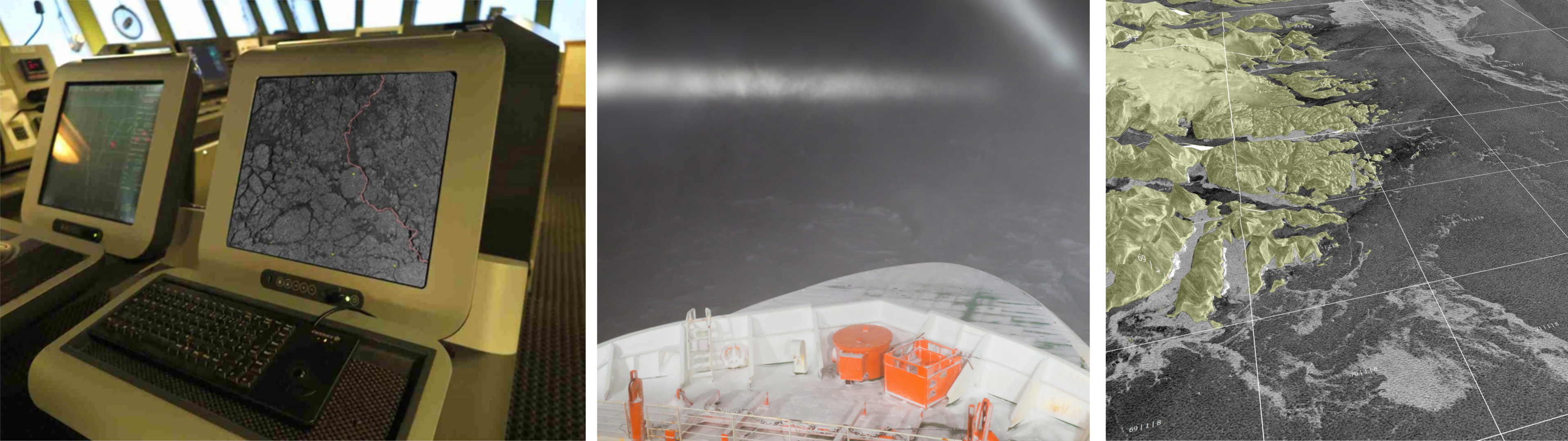
Drift+Noise Polar Services maps and user interface
Operational Ice Maps are produced on the fly by the German company Drift+Noise Polar Services based on data from optical, active, and passive microwave satellites at both high and low resolutions. After processing, extracted sea ice information in the desired area of interest is sent via communication satellites directly to the customer.
Left: A Sentinel-1 radar image visualized on board of an icebreaker. The red lines shows the cruise track navigating around a thick multi-year ice floes.
Centre: It is a difficult task to find the optimal route through the ice when it is dark and foggy. Fortunately the Sentinel-1 radar satellites produce high resolution images of the ice cover even in such conditions.
Right: Visualization of satellite images can be enhanced by combining them with a landmark and digital elevation model. Shown are ice fields at the coast of southern Greenland.