8. Digital image processing
A digital image is a chorological matrix of pixel values. The size of the squares in the grid, the pixel, is equal to the spatial resolution of the (satellite) image and depend upon the instrument providing the data. Similarly the numbers in the grid are determined by the ability of the equipment to distinguish variations. Digital images often contain values between 0 and 255, which are matched exactly by the capacity of 1 byte in the computer.
Pixels are usually coded in bytes (1 byte = 8 bits = 28 = 256 values) representing a gradation from black (value= 0) to white (value = 255).
The chorological matrix is loaded into the computer and the individual squares in the grid are represented by a dot on the screen, a pixel (= picture element). The numerical value in each matrix square is referred to the corresponding pixel-position with a (x,y) coordinates. Every pixel is given a grey shading corresponding to the pixel value. Now the matrix will appear on the screen as an image or a thematic map.

A satellite image is composed of pixels, distributed in rows and columns
Multispectral images
The sensor measures the reflection and radiation in many parts of the electromagnetic spectrum. The resulting images are referred to as bands. The sensor onboard Landsat 7 inspects the Earth in seven bands as shown in the following table.
| Band | Spectral definition | µm |
|---|---|---|
| Band 1 | blue-green | 0.45-0.52 |
| Band 2 | green | 0.52-0.60 |
| Band 3 | red | 0.63-0.69 |
| Band 4 | near infrared | 0.76-0.90 |
| Band 5 | mid infrared | 1.55-1.75 |
| Band 6 | far(thermal) infrared | 10.4-12.5 |
| Band 7 | mid infrared | 2.08-2.35 |
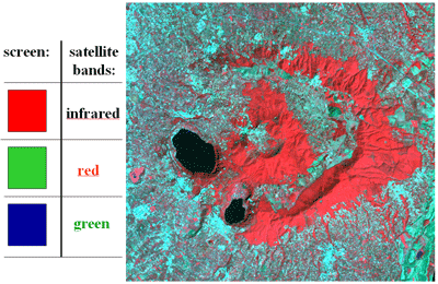
To create a coloured satellite image, three black and white images are superimposed. Each of these is taken from a specific wavelength range (also called a band). For display or printing, one colour (either red, green or blue) is attributed to it. So the grey levels have been changed in to red, green or blue levels. By addition of colours when superposed, the final image will comprise a range of colour.

To create an image showing natural colours the red colour is attributed to the red band, green colour to the green band and blue colour to the blue band. The constructed image shows as in this image from Alban Hills south of Rome, Italy green forest areas and blue lakes.

By experience it has been found that other band combinations are very useful. Vegetation reflect near infrared light because the chlorophyll in the green leafs cannot use near infrared light in the photo synthesis. On the other hand red light is used by the plants. Therefore to visualize the vegetation cover in an area red colour is attributed to the near infrared band, green colour to the red band and blue colour to the green band. The result is a false colour image in which vegetation is visualised in different shades of red.