
Monitoring Earth's surface
Using satellites to scan Earth's surface reveals a plethora of information that is difficult or impossible to see from the ground. From their vantage point high above us, satellites can collect data on the land, ocean and ice caps to monitor the changing environment and support responses to natural disasters.


Images of our planet are acquired continuously from orbit to better understand the environment we live in and help protect it for the future. These images show the world through a wide-enough frame that large-scale phenomena can be observed with an accuracy that would take an army of ground-level observers to match.
And because Earth observation satellites remain in place for long periods of time, they can highlight environmental changes occurring gradually. Looking back through archived data, we can see the steady clearing of the world's rainforests, an annual rise in global sea level and an increase in the number and intensity of wildfires.
ESA remains dedicated to developing cutting-edge spaceborne technology to monitor Earth's surface, and consequently improve daily lives, support effective policy making and benefit businesses and the economy. It does this using a fleet of Earth observation satellites.
What is Discovery & Preparation doing in this area?
To ensure that ESA remains a world leader in monitoring Earth's surface from above, ESA Discovery & Preparation supports novel research to maximise benefits from the Agency’s satellite missions, as well as studying the feasibility of new missions.
Current missions
ESA's Soil Moisture and Ocean Salinity (SMOS) mission is dedicated to making global observations of soil moisture over land, and salinity over oceans. In support of this and other missions with similar objectives, Discovery & Preparation studied the concept of a soil moisture mission back in the early 2000s, followed by an in depth analysis into how soil moisture could be monitored using optical and radar measurements.
Looking to Earth's poles, CryoSat measures the thickness of polar sea ice and monitors changes in the ice sheets that blanket Greenland and Antarctica; it is a mission highly relevant to addressing questions surrounding climate change and its impact on our planet. The importance of such missions has long been appreciated by ESA and Discovery & Preparation, which first explored a potential sea ice mission at the beginning of the century. A later study investigated how measurements from space, air and ground could be combined to support mapping of arctic sea ice.

CryoSat isn't ESA's only map-making mission. Proba-V was a washing machine-sized technology demonstration mission that mapped land cover and vegetation growth across the entire planet every two days. A very successful study explored how data from the satellite could be combined with historical climate data to look at the susceptibility of parts of southern Africa to drought.
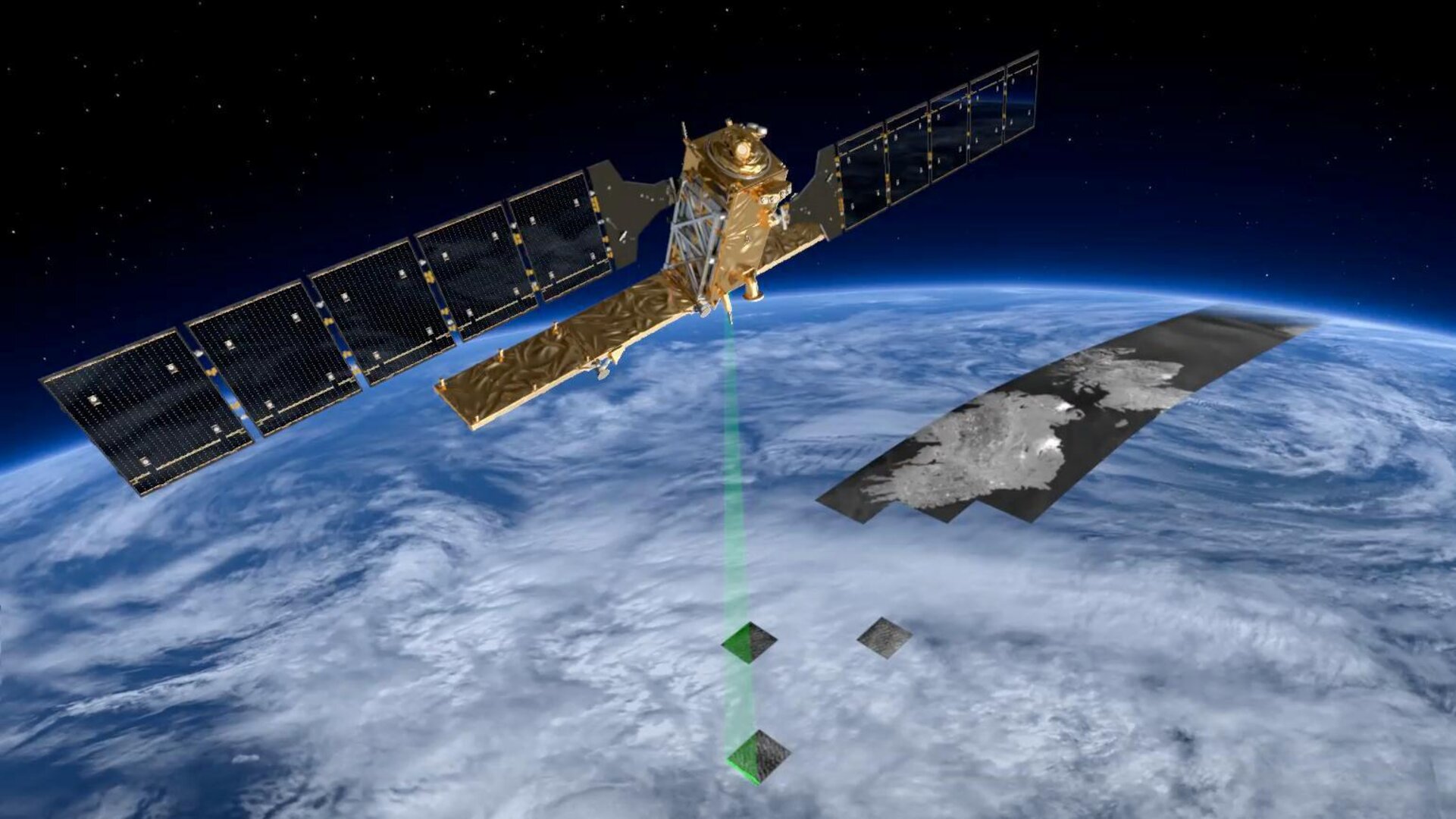
Meanwhile, the Copernicus Sentinel-1 mission provides radar imagery to help us understand the land and ocean, partly thanks to a Synthetic Aperture Radar (SAR) instrument – a detection system that sends out and receives pulses of radio waves to create very detailed images of the Earth's surface below. Many Discovery & Preparation studies have investigated how SAR can be used to find out more about Earth's surface; Airbus and Diam both used Copernicus Sentinel-1 as an example to explore how SAR on board satellites could cooperate with uncrewed aerial systems to improve our view of Earth from space, and another study explored how SAR data could be combined with navigation data to study tectonic processes in Indonesia.

Copernicus Sentinel-2 is also providing imaging – in the optical part of the spectrum – for land monitoring, for example to investigate vegetation, soil and water cover, inland waterways and coastal areas. A study that finished in 2019 developed a model to combine Copernicus Sentinel-1 and -2 data to monitor crops more effectively. Another looked into how data from the two missions could be used for disaster risk reduction and a third developed tools to detect and monitor slow-moving landslides using Copernicus Sentinel-2 data. Most recently, Discovery & Preparation funded an early technology development project that calibrated information on water depth from Sentinel-2 using the laser altimeter on NASA's ICESat-2 satellite; the result is an efficient novel technique to map the world's dynamic coastal zones.
Future missions
Looking to the future, the FLourescence EXplorer (FLEX) mission will map vegetation to measure photosynthetic activity. Discovery & Preparation supported the preliminary concept review for FLEX, as well as a mission performance analysis and a requirements consolidation study. A decade ago, two studies by Deimos Space and the University of Bologna explored how FLEX could work with Copernicus Sentinel-3 on a new way of monitoring photosynthesis to assess vegetation on the ground.

The Biomass mission will also provide crucial information about the state of our forests. Biomass will look down to Earth through a charged region of the atmosphere known as the ionosphere, which will impact the quality of the images it takes. Three studies in 2016–2018 mapped the ionosphere over Southeast Asia, South America and Africa to support Biomass to collect the best possible data.
A 2018–2020 study looked into how large 'deployable mirrors' could be actively corrected in space to maintain their perfect shape. Bigger mirrors can capture more light, but the larger they get, the trickier it becomes to maintain a perfect shape. Especially when that mirror is made of multiple segments that fold out once the spacecraft reaches its destination. One mission type that the study focused on was looking at Earth’s surface in high resolution from geostationary orbit.
What else is ESA doing?
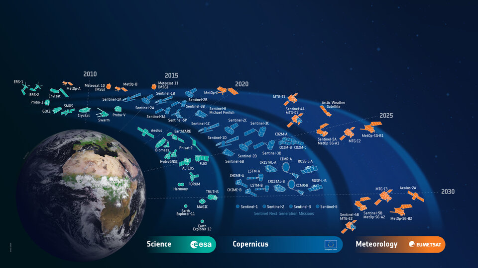
ESA has been monitoring Earth’s surface since the launch of Meteosat-1 in 1977. Although their primary focus is meteorology, several of the Meteosat satellites also contribute to surface monitoring. In total, seven Meteosat satellites were launched as part of the first generation, after which ESA worked with EUMETSAT to develop a second generation of Meteosat satellites to provide more comprehensive and frequent data. The first satellite in a third generation launched in December 2022.
ESA has also developed and now operates a number of Earth observation missions dedicated to scientific research into Earth’s surface, including ice observer CryoSat and soil moisture and ocean salinity monitoring SMOS. Several missions are planned for launch over the next few years, including forest scanner Biomass, vegetation observer FLEX and double-satellite Harmony, which will address key scientific questions related to ocean, ice and land dynamics. These Earth Explorers focus on Earth’s surface; several others exist to monitor many different parts of the Earth system such as the atmosphere and magnetic field. Discovery & Preparation supports early studies of all the Earth Explorers, most recently the Far-infrared Outgoing Radiation Understanding and Monitoring (FORUM) mission which will ultimately improve climate models.
ESA is also developing the Sentinel family of missions specifically for the operational needs of the Copernicus programme. Whilst Copernicus Sentinel-1, -2 and -3 are dedicated to monitoring Earth’s surface, Sentinel-4 and -5 focus on atmosphere monitoring and Sentinel-6 measures global sea-surface height. The current suite of Sentinels is being expanded with six new missions, one of which is the Copernicus Hyperspectral Imaging Mission for the Environment (CHIME). CHIME will support EU policies on the management of natural resources, ultimately addressing food security.
What are other space agencies doing?
NASA has its own suite of satellites monitoring Earth's surface from space. Recently launched SWOT will observe Earth’s surface water and Aqua aims to improve our understanding of the water cycle, whilst CYGNSS monitors choppy ocean waters during hurricanes to predict wind speed and ocean surges when the storm hits the land. CYGNSS isn’t the only satellite supporting natural disasters; Suomi-NPP monitors natural disasters such as volcanic eruptions and wildfires, as well as land cover, vegetation productivity, sea and land surface temperatures, sea ice, land ice and glaciers.
ICESat-2 is NASA's eyes on ice, measuring ice sheet elevation and sea ice thickness to observe changes in Greenland and Antarctica. Terra also monitors ice, as well as the ocean, land and snow. Meanwhile SMAP focuses on soil moisture, detecting where soil is frozen or thawed to improve our ability to monitor and predict floods, droughts and crop yields. And the ECOSTRESS instrument onboard the International Space Station measures plant temperatures to reveal their water needs.
NASA's Landsat missions provide the longest continuous space-based record of Earth's land in existence. They are a partnership with the US Geological Survey and take very high-resolution images to monitor urban growth, natural disasters, agriculture, forest loss and regrowth, and much more.
NASA also often partners with European agencies on space missions, including a set of satellites developed with French space agency CNES that measure the 'hills and valleys' of the ocean surface. CNES has contributed – including through supplying instruments – to many missions that monitor Earth’s surface, including ESA's SMOS, Proba-V and FLEX missions. Through the PEPS digital platform, the French agency also makes Copernicus Sentinel data available to all European citizens.
Aside from having long been involved in processing and archiving data from ESA Earth observation missions, German Aerospace Center DLR also operates twin satellites TerraSAR-X and TanDEM-X. TerraSAR-X provides data for a wide range of applications, including studying hydrology, geology, the climate and the ocean, whereas the main purpose of TanDEM-X is to generate an accurate 3D map of Earth’s surface. Most recently, in April 2022 DLR launched the EnMAP mission to monitor Earth’s surface, especially agriculture, forestry, soil and geological environments, as well as coastal zones and inland waters.
Japanese space agency JAXA is also busy monitoring Earth’s surface from space. The Agency’s series of four ALOS missions have been contributing to finding out more about the land and monitoring environmental hazards since 2006. Meanwhile, their GCOM satellite pair are respectively used to monitor the climate – including through measurements of vegetation, snow and ice – and water circulation – including through measurements of ocean temperature, water levels and snow depths.
Last updated 19 December 2022.