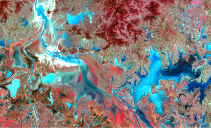
China environmental phenomena monitored from space
Western China is a very seismically active area and has had many catastrophic earthquakes during its history. A joint European-Chinese team is using satellite radar data to monitor ground deformation across major continental faults in China to understand better the seismic cycle and how faults behave.
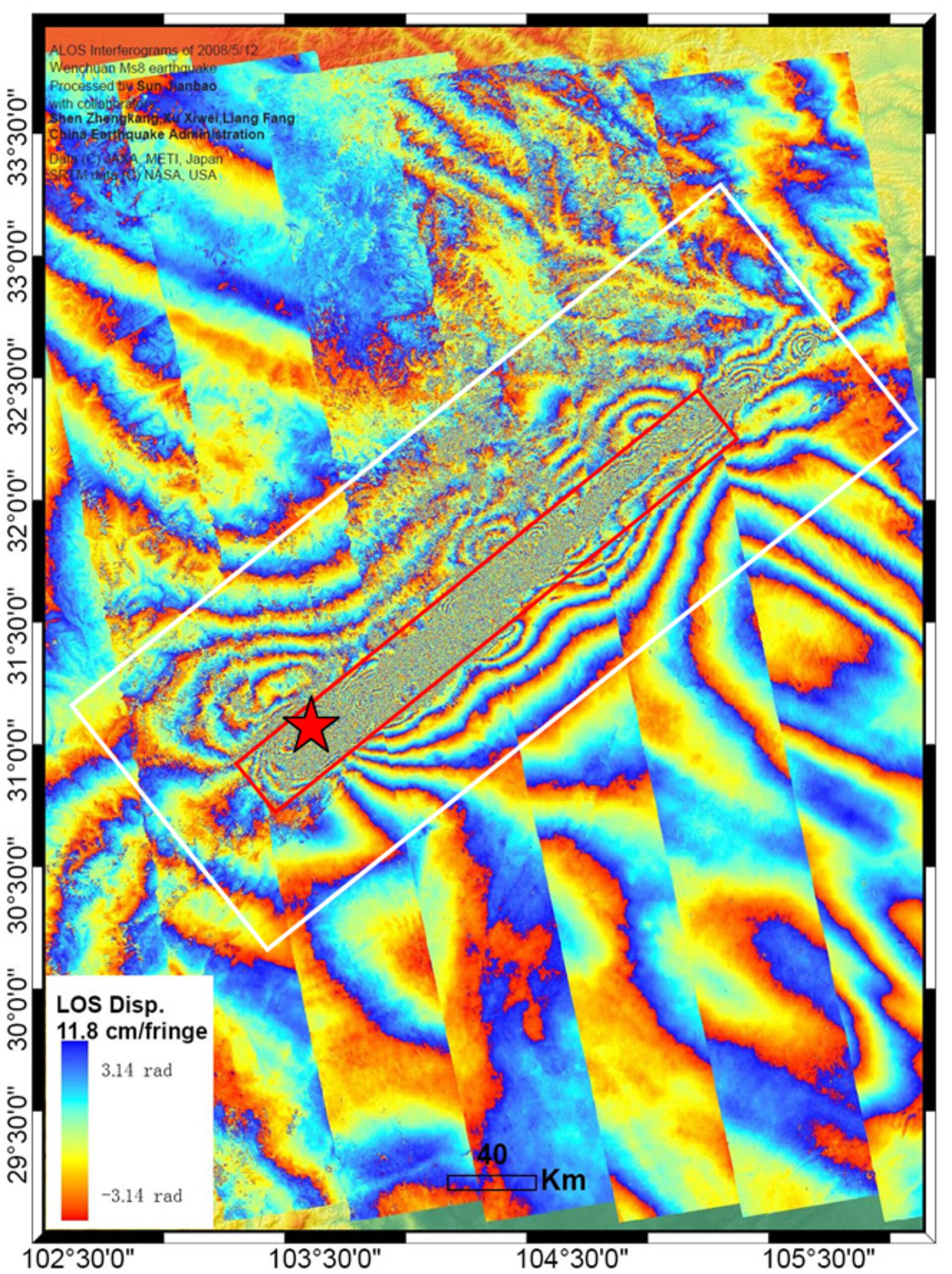
Using Synthetic Aperture Radar (SAR) satellite data and a technique known as SAR Interferometry (InSAR), along with GPS data, scientists participating in ESA’s Dragon 2 Programme have been able to measure the ground deformation that occurred during the Wenchuan earthquake that struck China’s Sichuan Province last May.
InSAR involves combining two or more radar images of the same ground location in such a way that very precise measurements – down to a scale of a few centimetres or even millimetres in some cases – can be made of any ground motion taking place between image acquisitions.
Using the InSAR technique on data acquired before and after the Wenchuan earthquake, Dr Sun Jianbao of the Institute of Geology, China Earthquake Administration (IGCEA), Prof. Shen Zhengkang of IGCEA and Peking University, and collaborators including Dr Cecile Lasserre from France’s Laboratoire de Geophysique Interne et Tectonophysique generated ‘interferogram' images, which appear as rainbow-coloured fringe patterns, showing the ground displacement that occurred during and after the earthquake.

The Wenchuan earthquake occurred on the Longmen Shan fault, along the eastern margin of the Tibetan Plateau. Following major earthquakes, changes in stress along the faults in the region can lead to subsequent earthquakes. Using InSAR and GPS data, scientists are able to measure and monitor where and how this stress changes as well as how any associated deformation is distributed.
"Combining InSAR with GPS data, we have learned that some regions on the fault did not rupture that much during the earthquake. We must then ask ourselves if the energy is still partially locked and therefore continuously accumulating for the next ‘big one’, or perhaps there was not that much energy accumulated in the regions prior to the quake," Shen said. "By combining the co- and post-seismic study results, we are about to answer these questions.
"If the area is moving slowly after the quake, then we know it is not accumulating energy, so we believe it to be safe. If, however, one area on the fault is not slipping but there is creeping movement around it, then we know that is a bad sign and we have to watch it more carefully."
Earthquake monitoring is only one of numerous Dragon 2 Programme research themes, which range from agriculture and forests to flooding and landslide monitoring, assessing drought, air quality, oceanography and climate. Preliminary results of the 25 ongoing projects were presented at the Dragon Symposium in Barcelona last week.

The nearly 200 symposium participants also heard how effective the Chinese measures taken last year ahead of the Olympic Games to improve air quality were. The measures, in place from 20 July until 20 September, included taking 50 percent of Beijing’s 3,5 million vehicles off the road and closing factories in and around Beijing.
Using the GOME-2, an atmospheric instrument on MetOp, Dr Ronald van der A of the Royal Netherlands Meteorological Institute (KNMI) and Prof. Pucai Wang of the Institute of Atmospheric Physics, the Chinese Academy of Sciences (IAP-CAS) evaluated the direct effect of these measures and found the levels of nitrogen dioxide (NO2) reduced by about 60% above Beijing. The team confirmed these findings using data from the Dutch-Finnish OMI satellite instrument.

By comparing MetOp’s GOME-2 measurements available at KNMI with air-quality model results, the team was able to determine that although the air quality measures were especially effective in the Beijing area, they were also noticeable in the surrounding cities, with Tianjin experiencing a 30% NO2 reduction and Shijiazhuang a 20%.
"We could really see the effects of the measures taken by the government. There was a huge reduction in nitrogen dioxide, more than we expected at first," van der A said.
Also unveiled at the symposium was the first Envisat ASAR wide swath image of the Kuroshio Current inverted to radar Doppler velocity. The image reveals the structure of the Kuroshio Current off China’s coast southwest of Japan with speeds up to 1,5 m per second.
The Kuroshio Current – equivalent to the Gulf Stream in the North Atlantic – is a warm current in the western Pacific Ocean. Its tropical waters transport heat northward along the east coast of Asia.
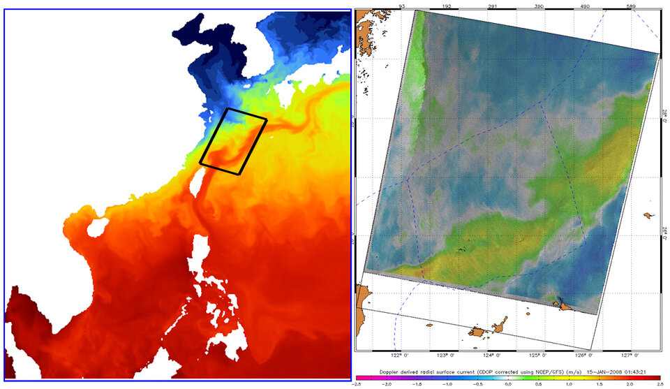
Prof. Johnny Johannessen of Nansen Environmental and Remote Sensing Centre, Dr Bertrand Chapron of IFREMER (the French Research Institute for Exploitation of the Sea) and Dr Fabrice Collard of France's CLS (formerly the BOOST Technologies Company) compared the ASAR image to a sea-surface temperature model, which clearly shows how the current moves warm water from the tropical Pacific towards the coast of Japan.
"The radial Doppler velocity map shows the strong southwest-to-northeast motion associated with the path shown in the sea-surface temperature model, so it confirms the velocity pattern associated with the Kuroshio Current," Johannessen said. "Since we removed the effects of wind and waves, what is shown is close to a picture of the pure surface current projected in the SAR-looking direction."