ERS-2 data vital for maritime security
Data from ERS-2, ESA’s veteran spacecraft, is experiencing an increasing demand as the 12-year-old mission’s products and services are playing a vital role in the initial activities for Global Monitoring for Environment and Security, such as the MARitime Security Service project which addresses the European concern of illegal marine trafficking.
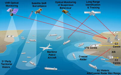
The MARitime Security Service (MARISS) is a GMES Service Element (GSE) initiative that integrates near real time satellite Earth Observation (EO) data with conventional vessel tracking data to deliver an understanding of the maritime situation to coast guards, navies and border police forces in Europe.
Within the MARISS partnership, service providers require Synthetic Aperture Radar (SAR) imagery such as that provided by ERS-2 within 15 to 20 minutes in order to rapidly detect vessels and extract their positions. This data is integrated with coastal surveillance systems such as coastal radar, the Automatic Identification System (AIS) and the Vessel Monitoring System (VMS) for tracking fishing vessels.
With this information, service providers can locate all vessels not reporting their position using conventional identification systems and transmit the position of these non-cooperative vessels to the relevant authorities in less than 30 to 60 minutes of the satellite overpass.
Service providers speak

The service providers within the MARISS consortium are Italy’s Telespazio, Spain’s GMV, France’s Collecte Localisation Satellites (CLS), Portugal’s EDISOFT and Skysoft, the United Kingdom’s QinetiQ and the Norway’s KSAT. These companies are currently delivering prototype services to the Italian Guardia Costiera and the Ministero dell’Interno, the Spanish Guardia Civil and Navy, the French Departement des Affaires Maritimes, the Portuguese Department of Maritime, the Irish Navy Service, the Swedish Coast Guard, the Finnish Border Guard, the European Maritime Safety Agency (EMSA) and Frontex, an EU agency tasked to coordinate the operational cooperation between Member States in the field of border security.
Antonio Giancaspro of Telespazio said: "The ERS-2 MARISS support was perfect team work between service providers/end users, national ground station/segment operators and ESA. In teamwork, a data provision timeliness of less than 15 minutes for Synthetic Aperture Radar (SAR) data was achieved. This has contributed to reaching strict temporal performances for the needs of Maritime Authorities."
EDISOFT’s Teresa Cardoso said: “The experience with ERS-2 has been very positive for several reasons. With the acquired set of images, we have been able to detect and classify vessels at low cost. This detection process has been subject to different activities of verification like, correlation with AIS, Vessel Traffic Management Systems (VTS) and VMS, with the support of the Portuguese Navy, always with very encouraging results.
"The ERS-2 mission is very flexible, allowing changes in the acquisition planning with very short notice, which is a feature very much appreciated by EDISOFT, and especially by the users of our service. In addition, during the EDISOFT service it was possible to provide a vessel detection service in less than 1 hour after acquisition, which is the Sentinel 1 required timeliness."
The use of ERS-2 data has been the key to succeeding in the delivery of Maritime security-based services
Celestino Gómez Cid of GMV said: "The use of ERS-2 data has been the key to succeeding in the delivery of Maritime security-based services for national and European Union authorities. In particular, ERS-2 has provided the required products with less than a one-hour delay after acquisition and provided a near real time processing chain by downloading data close to the area of interest thanks to ground stations.
"With its flexible and light product formats, ERS-2 has also simplified the processing and reduced the delays in transferring the data. In addition, it has matched the quality requirements for maritime security products production and reacted to security context changes and user needs quickly and easily."
CLS’s Jean-Yves Le Bras said: "In the framework of MARISS, CLS acquired ERS-2 images through the Mas Palamas station in September 2007 to perform trials in the West Mediterranean Sea. The trials have shown that near real time capability and good geolocation performance can be obtained from ERS-2, allowing for potential in an operational context. In particular coupling with other missions could be valuable, for example provision of additional information in the co-located part of an Envisat Wide Swath image."
Satellite synergy within 30 minutes
Key users have also expressed considerable interest in the 30-minute time difference between the overpasses of ERS-2 and Envisat. The minimal time lag allows data to be retrieved and used from ERS-2 when Envisat is being used in a different mode. For example, in the case of oil slick monitoring, Envisat can obtain acquisitions in Wide Swath Mode while ERS-2 provides a more detailed view. This unique capacity is approaching update times of conventional systems, such as the AIS, and is currently unique for satellite surveillance systems.
ERS-2 sets stage for GMES
ERS-2 with its well-defined products and services has an important role to play in the preparation for GMES, building on the established customer base through the generation of policy-relevant services. Until the launch of GMES-dedicated missions, such as Sentinel, the retention of ERS-2 will provide the necessary additional capacity to maintain the uninterrupted data flow that is critical to the programme.
GMES responds to Europe’s needs for geo-spatial information services by bringing together the capacity of Europe to collect and manage data and information on the environment and civil security, for the benefit of European citizens. As the main partner to the European Commission (EC) in GMES, ESA is the implementing agency for the GMES Space Component, which will fulfil the space-based observation requirements in response to European policy priorities.
The GMES Service Element (GSE) has been preparing user organisations in Europe and worldwide for GMES by enabling them to receive and evaluate information services derived from existing EO satellites since 2002.