The Arctic – part of Europe’s maritime interest
Europeans have exploited Arctic resources for centuries. Current exploitation activities include:
- Hunting – Indigenous hunters pursuing seals, walrus, polar bears and other Arctic animals
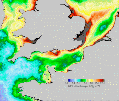
- Fishing – Several commercially important fish stocks have collapsed in recent decades, although some have recovered. Over-fishing and changes in marine ecosystems — possibly caused in part by climate change — have led to serious reductions in many sea-bird colonies, e.g. in Svalbard
- Oil, gas and mineral exploitation – The politically stable Arctic holds a significant share of the world’s gas and oil reserves, which may make the region even more important in the future. European companies are playing key roles in developing Arctic reserves. However, oil exploitation in the Arctic brings environmental dangers. Installations, roads and pipelines contribute to land fragmentation. Clean-up operations of oil spills on land and in ice-covered waters are difficult, and oil slicks can be carried with ocean currents to seas and shores far away.
- Tourism – Shipping tourism is on the increase in some regions, such as Alaska, Greenland and Svalbard. Aircraft and icegoing vessels allow travel to very remote areas. Today, tourists can even visit the North Pole in icebreakers or aircraft. Snow-scooters and all-terrain vehicles make it possible for tourists to explore new polar landscapes and places of interest. New 'products' are marketed, such as the Arctic's northern lights
In addition, as climate change causes reductions in sea ice extent, previously impassable areas are progressively becoming regular transportation routes between Europe and the Far East.
All of these activities result in significant increases in the level of stress and potential for accidents with grave consequences for this fragile region. Furthermore, given the inherent hostility of the Arctic environment, the potential for accidents is significantly higher than in other areas. Therefore, increased monitoring is a top priority for Northern states including Canada, Finland, Norway, Sweden and Denmark.
To improve safety and reduce the risk of accidents in the region, national governments are making greater use of satellite based monitoring. Given the difficulties in deploying conventional monitoring and surveillance systems (eg patrol vessels, aircraft), satellite based monitoring are seen as a cost effective tool for wide area monitoring of environmental conditions. In particular, satellite based radar imagery can provide reliable detection of icebergs in the North Atlantic region and also a characterisation of sea ice conditions, including the distinction between first year and multi-year ice and the identification of leads.
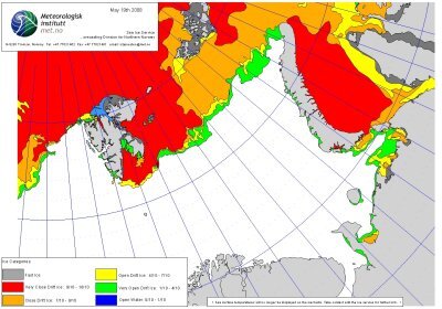
Sea ice monitoring – Envisat ASAR data support routine production of ice information products for the different Arctic regions. In particular for the Norwegian, Barents, Kara, and Laptev seas which are subject to systematic increase in oil and gas production activities and shipping levels, the national ice services now routinely integrate ASAR data into the production of both standard and customised ice products. The example image provided by Met.No shows sea ice conditions in the Barents and Kara Sea areas for 15 May 2008. For access to more products, go to IPY Ice Portal
and click on the Barents Sea section of the map.

Ice berg detection and tracking – Maritime activities in the North West Atlantic are subject to regular risk from icebergs at certain times of the year. The International Ice Patrol conducts regular airborne surveillance and since 2003, this is augmented through satellite based iceberg detection delivered by Canadian company C-CORE. Both Envisat and Radarsat imagery delivered in near real time are used. Users are both public sector organisations (eg coast guards) as well as private sector operators such as oil and gas production companies active in the Grand Banks area. The image shows icebergs (in red) and unknown targets (in yellow) detected in the Grand Banks area during April 2008.
For more information and access to a range of Arctic information products, please go to the following web site:
IPY ICE Logistics Portal.