Why is space relevant for maritime issues?
Space technologies have been serving the maritime community for over 30 years. Initially through improved meteorological forecasts based on satellite observations and satellite telecommunications links for improved maritime safety, and now through enhanced navigation accuracy, marine environmental monitoring and maritime surveillance, satellite technology is becoming increasingly important for a wide range of maritime activities.
On the occasion of the first EU Maritime Day on 20 May, ESA is taking the opportunity to highlight the contribution of space technologies to three areas currently being addressed in the context of the recently agreed European Integrated Maritime Policy. These are:
- Monitoring and support to Arctic operations
- Marine Environment protection
- Integrated Vessel Surveillance
These pages give access to information services currently delivered on an operational basis to regional, national and European level public institutions as well as private sector operators. In addition, background information on some of the technical aspects is provided. If even more detailed information on ESA managed activities in the maritime sector is required, please contact our helpdesk at EOHelp@esa.int. EOHelp@esa.int
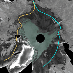
The Arctic – part of Europe’s maritime interest
For centuries, the Arctic has been a source of natural resources for Europe and with new reserves of oil and gas becoming available, this is set to continue for the foreseeable future. It is also a highly sensitive environment with many processes acting as early indicators of climate change impacts. As a result of current and expected future reductions in sea ice coverage, the region will also experience significant increases in commercial traffic between Europe and the Far East. This will be exacerbated by increased levels of tourist traffic. The increased exploitation of the Arctic environment will result in increased stress on a fragile set of ecosystems and habitats and increased risk of environmental disasters such as oil or chemical discharges into the marine environment resulting from accidents or deliberate actions.

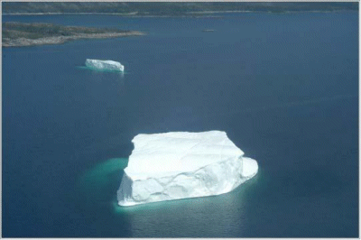
At the same time, the Arctic is a particularly hostile regime and safe operations require routine monitoring of environmental conditions to provide early warning of the evolution of hazards such as ice formation and iceberg movements.
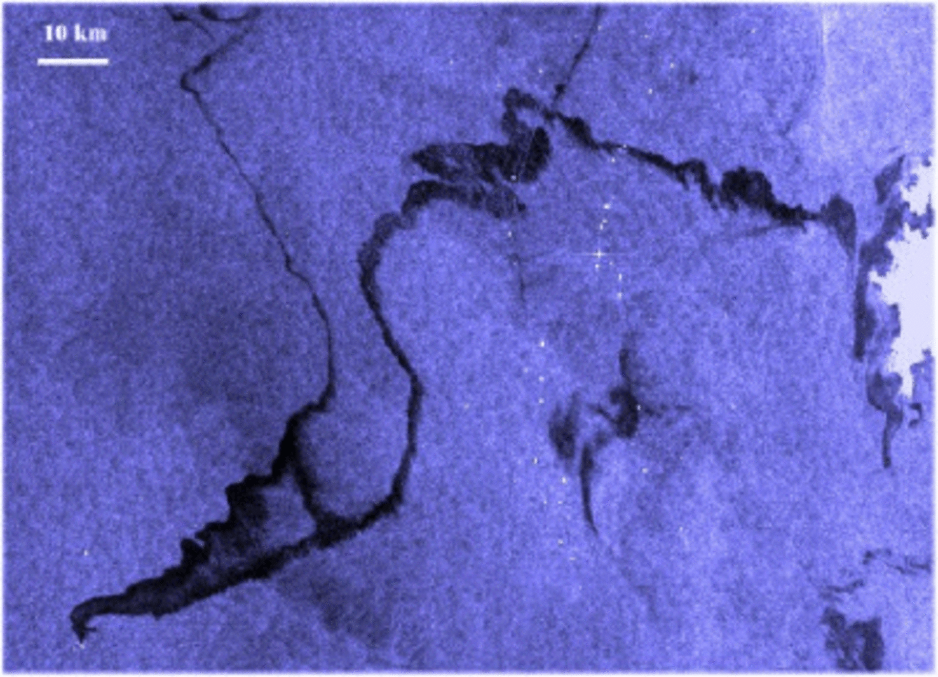
Due to the difficulties inherent in setting up traditional systems, satellite based monitoring and surveillance is of particular value for Arctic operations support. Satellite based radars such as the Envisat ASAR are already used on a regular basis for monitoring sea ice conditions, iceberg movements and tracking vessels while meteorological satellites such as the European Polar System can provide high resolution wind information for the region to support offshore operations. Both Envisat and the meteorological satellites provide high precision sea surface temperature data to support regular monitoring of marine habitats as well as to support short term forecasting of future ice conditions.
Arctic information services based on satellite data PolarView portal
Where are the icebergs? Click here to see the latest icebergs detected by satellite in the North Atlantic.
Where is the ice? Click here to see ice conditions in the Arctic.
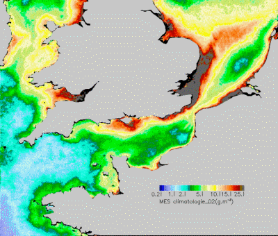
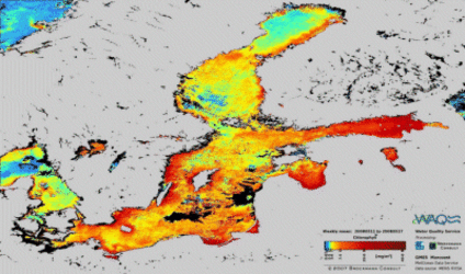
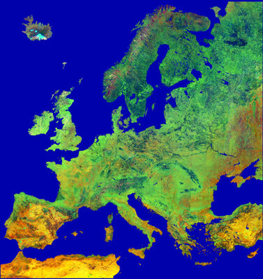
Protecting Europe’s Marine Environment

Click the map for Water Quality around the Europe
The marine environment is a vital resource for life on earth. The ultimate aim is to keep our oceans and seas biologically diverse and dynamic, and also safe, clean, healthy and productive. The marine environment is also a great contributor to economic prosperity, social well-being and quality of life. It provides resources which can be used to achieve greater economic potential, so its protection is crucial at a time when the EU is seeking to revitalise its economy.
Today, satellite based monitoring is providing routine support for operational monitoring of the marine environment. Examples include:
- Operational surveillance of European waters by radar satellites to detect illegal discharges of oil into the marine environment. The main component of the European action in this area is the Clean Sea Net service managed by the European Maritime Safety Agency which makes significant use of ESA’s Envisat satellite
- Routine monitoring of water quality parameters including chlorophyll concentration, transparency, suspended sediment and dissolved matter. Satellite based ocean colour measurements provide measurements of eutrophication such as chlorophyll concentration, transparency and detection of algal blooms. For coastal waters, the MERIS instrument on board the Envisat satellite provides a unique capability for monitoring estuaries and areas with high density of islands as well as waters within one nautical mile of the coastline.
What is the quality of the water around Europe at present? Click here for Water Quality around the Europe.
More water quality products and information click the right navigation bar and go to the Water quality Page
Maritime Security – ensuring situational awareness

European states are under an increasing responsibility to effectively control, protect and manage their territorial waters and exclusive economic zones. Under the various fisheries agreements, coastal states are responsible for monitoring their own fishing zones as well as the activities of their own fishing fleets. This is done through the use of satellite telecommunications based transmission of vessel location and identification data to the national authorities. It is planned to introduce an additional satellite radar based surveillance capability to enhance the surveillance effectiveness over the coming years.
Similarly, to counter illegal trafficking of persons, drugs, weapons, etc, at present, vessels are tracked through a combination of coastal surveillance (AIS, radar), satellite based transponder tracking (for fishing vessels) and airborne or surface patrol craft. The Eurosur initiative of the European Commission already highlights the expectations for the increased contribution of satellite based detection and tracking of suspicious vessels over the next 5 years.
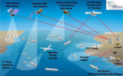
ESA is responding to this requirement through the development of the appropriate space technologies such as the next generation of operational satellite based radar systems and satellite based AIS. In addition, ESA is presently managing demonstration projects to qualify prototype capabilities to integrate satellite based vessel detection and tracking systems with conventional monitoring systems such as coastal AIS and radar systems. The figure below illustrates how the different surveillance capabilities can operate in an integrated framework.
New space based measurements for the maritime community
The examples highlighted here are based on the use of currently available space technologies. However, ESA is continuously working with the maritime community to develop new technologies that respond to evolving requirements of the different communities within the maritime domain.
In the framework of the Global Monitoring for Environment and Security initiative (GMES), ESA is developing a family of satellite missions known as the Sentinels. These missions respond to operational monitoring needs within Europe and continue the measurement heritage established by current missions such as Envisat and ERS-2. Specifically:
Sentinel 1 is a satellite based Synthetic Aperture Radar system that will support operational oil spill monitoring and vessel detection and tracking
Sentinel 3 includes a thermal infra-red instrument, a radar altimeter and an ocean colour instrument. This will support operational activities in:
Monitoring of ocean warming, in particular with respect to climate change – the thermal infra-red instrument will provide high precision measurements of sea surface temperature to continue the time series established by the ERS and Envisat ATSR instruments
Monitoring sea level rise – the radar altimeter, will contribute to maintaining the time series of measurements of the rising sea level established by the Topex-Poseidon, ERS, Envisat and Jason satellites
- Coastal environment monitoring – the high resolution ocean colour measurements will continue the unique capability of the MERIS instrument on board the Envisat satellite to provide reliable measurements of parameters such as transparency and chlorophyll concentration which are required at local, national and European level for effective monitoring of the state of the coastal environment.
In addition, for the research community, ESA will be launching two dedicated missions in the next 12 months:
The Soil Moisture and Ocean Salinity (SMOS) mission – this will provide ocean salinity measurements at the sea surface to support improved oceanographic monitoring and better understanding of ocean dynamics. For ocean salinity measurements, there are few historical measurements, and only a small fraction of the ocean is currently sampled on any regular basis. Salinity and temperature determine the density of seawater, and in turn density is an important factor driving the currents in our oceans. Ocean circulation plays a crucial role in moderating the climate by, for example, transporting heat from the Equator to the poles. Ocean salinity is therefore one of the key variables for monitoring and modelling ocean circulation. SMOS is planned for launch during 2009.
- The Gravity field and steady-state Ocean Circulation Explorer will provide extremely precise measurements of the Earth’s gravity field. Reducing the level of uncertainty in the variation of the gravity field enables more precise analysis of ocean current systems and a better understanding of regional ocean dynamics. Dubbed the 'Formula 1' of spacecrafts, this sleek high-tech gravity satellite embodies many firsts in terms of its design and use of new technology in space to map Earth's gravity field in unprecedented detail.
As the most advanced gravity space mission to date, GOCE is planned for launch in summer 2008 and will realise a broad range of fascinating new possibilities for the fields of oceanography, solid Earth physics, geodesy and sea-level research, and significantly contribute to furthering our understanding of climate change. Over its lifetime of about 20 months, GOCE will map these global variations in the gravity field with extreme detail and accuracy. This will result in a unique model of the geoid, which is the surface of equal gravitational potential defined by the gravity field – crucial for deriving accurate measurements of ocean circulation and sea-level change, both of which are affected by climate change.
ESA will also launch the Cryosat 2 mission to provide a unique measurement capability to assess the amount of ice in the Arctic region using innovative altimeter concepts.
In addition to Earth Observation, ESA is also working on other technologies to support the maritime community. In particular, in cooperation with the EC, ESA is working to develop satellite based AIS measurements to extend the capability for vessel identification and tracking beyond the current coverage of coastal systems. Initial work will begin during summer 2008.
Finally, the satellites that make current activities possible today merit special recognition:
The ERS-2 satellite has been operating since April 1995 and continues to provide the maritime community with regular radar imagery in support of oil spill and vessel detection activities and precise sea surface temperature measurements and sea level anomaly measurements to maintain the time series of measurements established with ERS-1 in 1991.
- Although designed as a mission to support the R&D community, the ASAR instrument aboard Envisat is one of the major pillars on which the EMSA CleanSeaNet operational pollution detection system is based. This is due to the combination of wide area coverage and reliable rapid delivery of the imagery to the central server through which all coastal EU Member States can access pollution data in a timely and efficient manner. Envisat is also supporting routine coastal environment monitoring with MERIS ocean colour measurements as well as maintaining the sea level and sea surface temperature time series of measurements to support climate change monitoring.