ESA's orbiting hurricane hunter back in action
After a three-year gap, the European Centre for Medium-Range Weather Forecasts is again routinely assimilating data from an instrument aboard ERS-2 that 'sees' wind fields over the ocean. The result is more accurate weather predictions – particularly in forecasting strong storms and hurricanes.
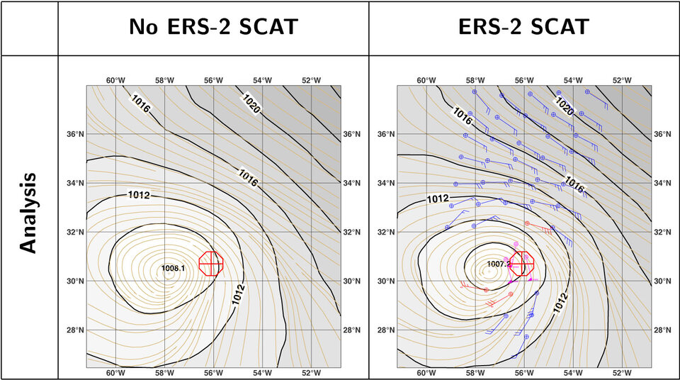
"The instrument is working at least as well as it did before – certainly not less," says Dr Hans Hersbach of the European Centre for Medium-Range Weather Forecasts (ECMWF). "We make use all the data sources available to maximise the accuracy of global weather forecasts, so having North Atlantic ERS-2 wind data available again for active use since 9 March 2004 is very good news.
"Our analysis of offline test runs showed on average a positive impact on global forecasts and the ability to correct for the positions of tropical cyclones."
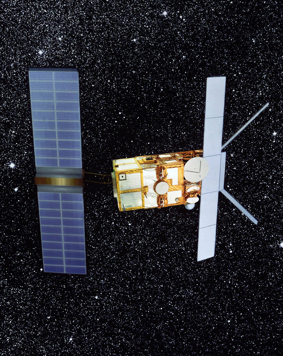
Next month ESA's ERS-2 satellite celebrates its ninth anniversary in orbit. Its payload includes a radar scatterometer that works by firing a trio of high-frequency radar beams down to the ocean, then analysing the pattern of backscatter reflected up again.
Wind-driven ripples on the ocean surface modify the radar backscatter, and as the energy in these ripples increases with wind velocity, so backscatter increases as well. Scatterometer results enable the measurements of wind speed and direction across the water surface.
What makes ERS-2's scatterometer especially valuable is that its C-band radar frequency is almost unaffected by heavy rain, so it can return useful wind data even from the heart of the fiercest storms – and is the sole scatterometer of this type currently in orbit.
Up until January 2001 the ECMWF assimilated global ERS-2 scatterometer results on a routine basis. The ECMWF is an international organisation supported by 25 European states charged with using powerful supercomputers to prepare medium-range weather forecasts for up to ten days ahead.
Overall ERS-2 functioned well, but problems began to occur with gyros used for spacecraft positioning. After six years of service the ESA engineers evolved an innovative 'gyro-less' mode of operating the spacecraft, but the new mode's positioning accuracy was initially insufficient to maintain operational scatterometer service, since the instrument requires simultaneous pointing accuracy across three axes.
ERS-2 also lost its onboard storage capacity, meaning that data from its instruments can only be acquired while within contact with a ground station - effectively ending its global mission.
However, that was not the end of the scatterometer's story. The array of ground station supporting the ERS mission is sufficient to cover the whole of the North Atlantic, and though degraded, scatterometer data continued to be collected across this region - an area of key interest for the meteorological user community – and attempts began to revive an operational scatterometer service.
In the summer of 2003 a development took place that led to ESA making ERS-2 wind products publicly available once more: a new software algorithm developed by the Belgian Royal Military Academy succeeded in compensating for the pointing degradation, regaining access to scatterometer measurements.
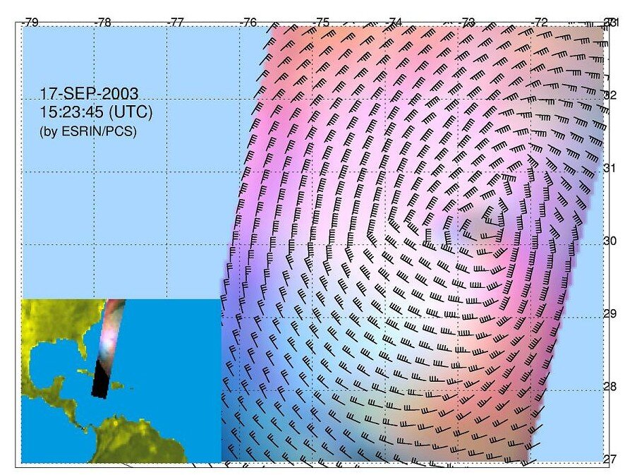
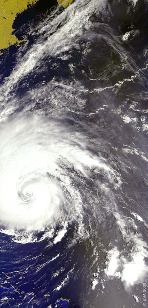
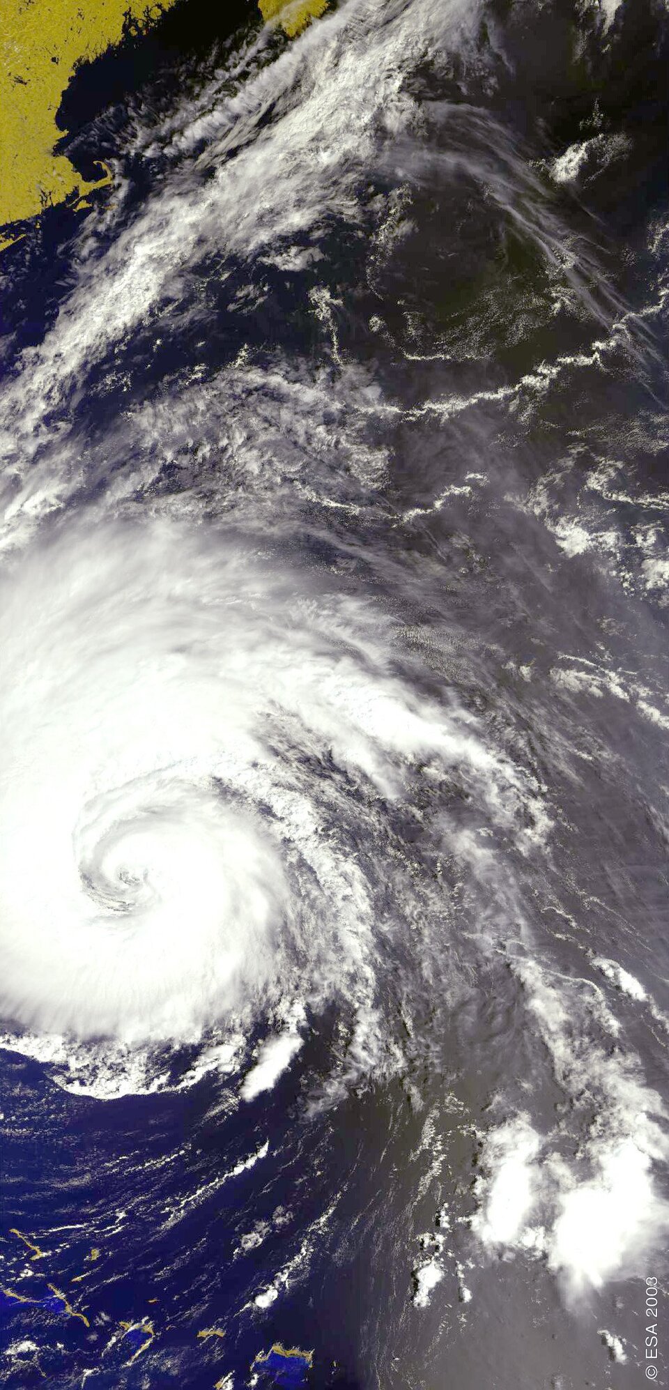
The return to service came in time for ERS-2 to provide a unique view of the pressure system at the centre of Hurricane Isabel as it descended upon the United States in September 2003.
Meanwhile wind experts at ECMWF began working with researchers from the Royal Dutch Meteorological Institute KNMI to improve the accuracy of the mathematical model that turns raw scatterometer data into geophysical facts – known as the geophysical model function.
"What we obtain from the scatterometer is not the actual wind speed and direction but measurements of radar pulses scattered from the water surface," Hersbach explains. "Converting the raw data into the geophysical values we are interested in is a complicated process that involves carrying out a co-location study – checking these results against values from our own model wind fields.
"At the end of the study we ascertain what the wind behaviour is for a particular scatterometer value, and we call this the geophysical model function. What we have done with KNMI is carry out a new co-location study using orders of magnitude more data than before.
"Some 20 million scatterometer observations were compared to our model winds, using five months of ERS-2 data –and developed a new geophysical model function that gives us much greater accuracy than before, particularly at higher wind speeds."
The success of this new geophysical model function made it feasible for ECMWF to resume near real time assimilation of scatterometer data. The scatterometer results gathered between 2001 and resumption of public service in 2003 will also be reprocessed using the new geophysical model function.
Once this gap is filled, the entire scatterometer archive stretching back to the launch of ERS-1 will also be reprocessed in the same way, producing a continuous long-term wind data archive for researchers.

With key engineering issues resolved, the last six months has shown ERS-2 to be an extremely stable platform and payload, the satellite's performance as good as it has ever been.
To maintain continuity of scatterometer coverage into the future, a new more advanced instrument called ASCAT is part of the payload for the ESA-designed and EUMETSAT-operated MetOp mission, due for launch in 2005.