• → European Space Agency

      • Space for Europe
      • Space News
      • Space in Images
      • Space in Videos
    • About Us

      • Welcome to ESA
      • DG's News and Views
      • For Member State Delegations
      • Business with ESA
      • ESA Exhibitions
      • ESA Publications
      • Careers at ESA
    • Our Activities

      • Space News
      • Observing the Earth
      • Human Spaceflight
      • Launchers
      • Navigation
      • Space Science
      • Space Engineering
      • Operations
      • Technology
      • Telecommunications & Integrated Applications
    • For Public

    • For Media

      • Media
      • ESA TV
      • Videos for professionals
      • Photos
    • For Educators

    • For Kids

    • ESA

    • Observing the Earth

    • Understanding Our Planet

    • Securing Our Environment

    • Benefiting Our Economy

    • About Observing the Earth

      • How does Earth Observation work?
      • How to get Earth observation data
      • Integrating Earth Observation in your job
      • Earth Observation users speak
    • EO programmes
    • The Living Planet
    • GMES
    • ESA's Earth Observing missions
    • Envisat overview
    • ERS overview
    • Earth Explorers overview
    • Sentinels overview
    • MSG overview
    • MetOp overview
    • Proba-1 overview
    • Third Party Missions overview
    • Opportunities with us

      • Education & training
      • International cooperation
      • Milestones & announcements
    • Multimedia

      • Image Gallery
      • Video Gallery
      • Online resources
      • RSS feeds
    • Services
    • Subscribe

    ESA > Our Activities > Observing the Earth

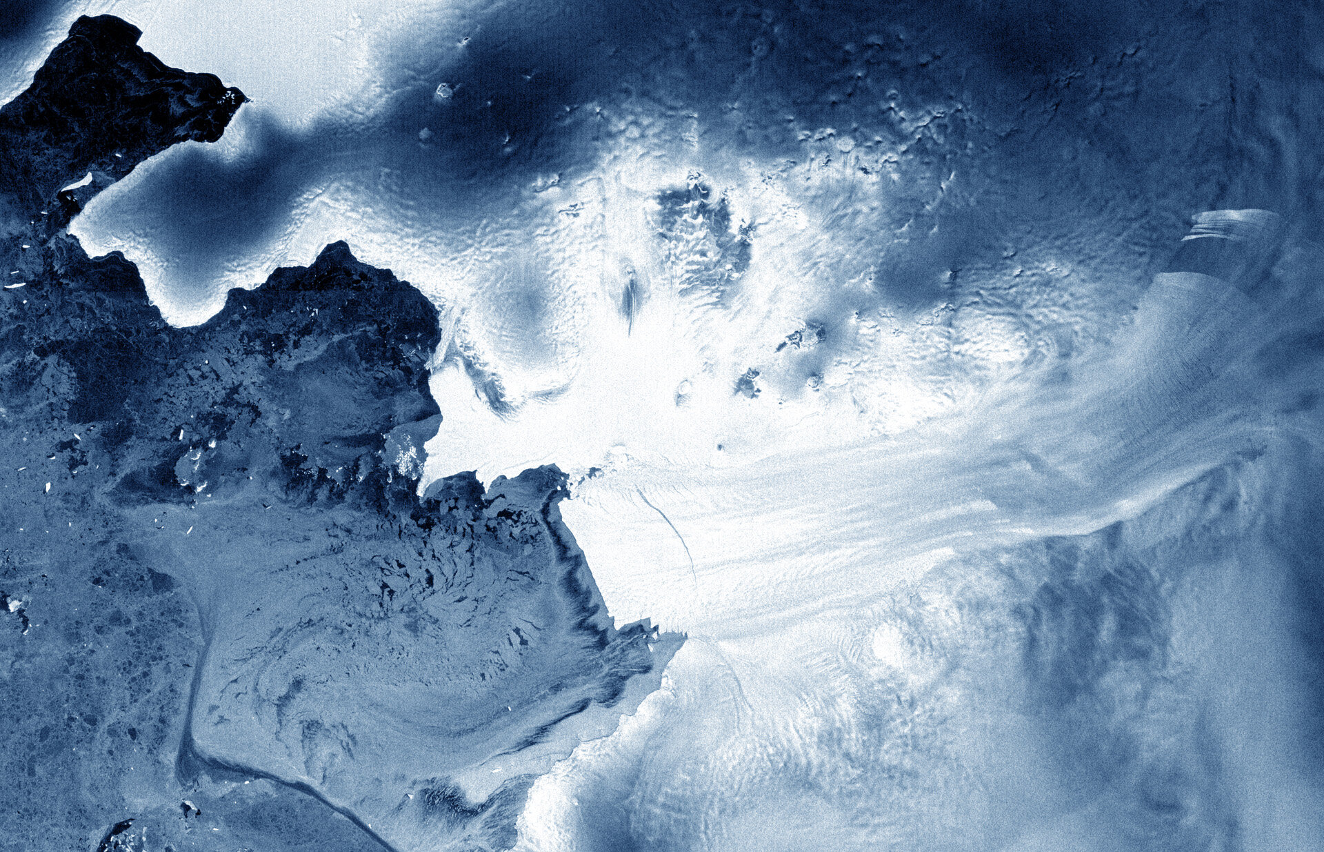
    Earth from Space: Pine Island cracked

    8 June 2012

    This image from the Envisat satellite shows the Pine Island Glacier in West Antarctica.

    Pine Island is the largest glacier in the West Antarctic Ice Sheet and one of the fastest ice streams on the continent, flowing into Pine Island Bay in the Amundsen Sea.

    Ten percent of the West Antarctic Ice Sheet drains out to the sea by way of this glacier.

    Scientists have found that the flow of Pine Island, along with other ice streams in Antarctica such as the nearby Thwaites Glacier, has accelerated in recent years. A melting of these two glaciers alone would contribute to global sea-level rise of over a metre.

    The image reveals a crack in the glacier’s tongue about 25 km long.

    Envisat saw a similar crack in 2007 which then gave birth to a new iceberg 34 km long and 20 km wide.

    Iceberg calving occurs in Antarctica each year and is part of the natural lifecycle of the ice sheet.

    This image was acquired by Envisat’s radar on 6 April 2012, just two days before contact with the satellite was lost.

    Over its ten-year lifetime, Envisat’s radar imagery was constantly used to monitor ice in the Antarctic. Satellite radars are particularly useful over polar regions because they can see through clouds and darkness.

    The Image of the Week is featured on ESA Web-TV, broadcast online every Friday at 10:00 CEST.

    Rate this

    Views

    Share

    • Currently 0 out of 5 Stars.
    • 1
    • 2
    • 3
    • 4
    • 5
    Rating: 0/5 (0 votes cast)

    Thank you for rating!

    You have already rated this page, you can only rate it once!

    Your rating has been changed, thanks for rating!

    150
    Tweet
    • Image of the week archive
    • Satellite Images
      Satellite Images
      Earth images gallery
    • Related missions
      • Envisat overview
      • Image of the week on ESA Web-TV

    Connect with us

    • RSS
    • Youtube
    • Twitter
    • Flickr
    • G+
    • Facebook
    • Livestream
    • Subscribe
    • App Store
    • LATEST ARTICLES
    • · Rare merger reveals secrets of gal…
    • · Watching for hazards: ESA opens as…
    • · ESA astronaut Timothy Peake set fo…
    • · Space drives e-mobility
    • · Proba-V opens its eyes
    • FAQ

    • Jobs at ESA

    • Site Map

    • Contacts

    • Terms and conditions