El Niño is yawning
Four years ago, torrential rains battered the Southern US, mudslides struck in Peru - and the inhabitants of Canada's west coast saved up to 30% on their winter heating bills. The cause? El Niño, a huge temperature shift in the Pacific Ocean which spawns climate changes globally. Today, using satellite Earth observation data, scientists are detecting the early warning signs of a new El Niño event and predicting that it will develop over the next 3 to 6 months, bringing climate changes to countries thousands of miles from the western Pacific, birthplace of the event itself.
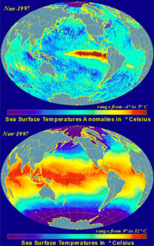
"In normal years, there's a large area of warm water in the western Pacific and colder water at the eastern side. In El Niño years, that warm water shifts eastward, which has major effects on the atmosphere above the ocean and thus the climate of the nearby countries," explains Joel Picaut, of France's Centre National d'Etudes Spatiales.
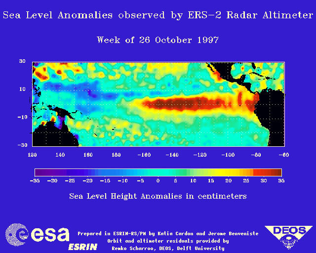
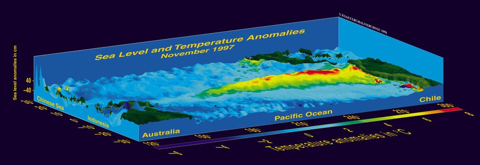
Imaging from space using radar altimetry and sea surface temperature measurements reveals that the trade winds near the Equator pile up a mass of water, warmed by the sun on its journey across the Pacific, which covers an area the size of Europe. This so-called 'warm pool' off the Philippine coast is in fact a plateau in the sea some 30 cm high and with a temperature of approximately 29°C - 5°C above average. In contrast, the water off the Galapagos Islands on the other side of the Pacific is normally a mere 20°C. When an El Niño event takes place, all this changes.
"No one is yet quite sure of the mechanism that causes an El Niño," comments Picaut. "It's clear that the movement of the warm water and the change in the wind patterns are closely linked, but we do not yet know which is the cause and which the effect." The warm water in the west causes convection in the atmosphere and a relatively constant wind from east to west - the trade winds. When the El Niño cycle begins, the trade winds reduce, no longer pushing water toward the warm pool and the mass of warm water begins to flow eastward, toward the Galapagos Islands and the Peruvian coast. "Over a period of 1-2 weeks, we see so-called 'westerly wind bursts', in which the direction of the trade winds reverses. At the equator, you see a very interesting effect, where the wind and the Earth's rotation combine to trigger 'Kelvin waves', which are like a wall of water 30 cm high moving across the pacific at about 200 km per day. You can see the Kelvin waves clearly and monitor their progress using radar altimeter and sea surface temperature data," says Picaut. These fast-moving Kelvin waves are the heralds of the more sedate progress of the main body of water, which travels at only 30 km per day. In January, scientists detected such a Kelvin wave near the International Date Line in the central Pacific.
"We don't yet know if the wind bursts and Kelvin waves are fundamental to the El Niño mechanism, or whether they are simply an effect on top of some underlying changes," comments Picaut. Despite the mystery surrounding the origins and mechanism of El Niño, scientists are making significant strides in the ability to predict its onset. "Although El Niño is cyclical, it's not like clockwork, and the strength of the effect varies dramatically from one event to the next. We had a strong El Niño in 1982/83, another in 86/87, a series of small ones in 91/92 and 93 and a huge one in 1997," comments Picaut. "In 1999/2000, we were actually in 'La Niña', which is the opposite effect." La Niña causes an increase in the trade winds and cooling of the waters around the Galapagos Islands.
"The ocean is the 'memory' of El Niño," says Picaut, "water has a heat capacity 1000 times that of the air, so it's the ocean that drives the event, and it's the ocean we must monitor to understand it." A 10-year programme is underway using buoys and floating sensor packages to gather ocean data from the sea itself. This data will help develop the next generation of computer simulations of El Niño. "We've already created a computer model which can help us predict an El Niño event from 6 months to a year in advance," explains Picaut, "but you can't put nature into a computer. We predicted the 1997 El Niño six months before it began, but we were taken completely by surprise by how strong it was."

Prediction may be an inexact science, but any warning is better than none at all. In the US, the prediction led to bulldozers moving in along the Californian coast to create better sea defences against the El Niño-charged Pacific rollers. With sufficient warning, countries like Peru and Chile, which will bear the brunt of rains 10-40 times heavier than normal, can prepare to deal with flooding by improving watercourses and moving people from the areas most threatened by flash floods and mudslides. "If you know El Niño is on the way, you can be ready," sums up Joel Picaut. Today, it looks as though preparations should get under way.
Once Envisat is in orbit it will continue to add a new frame each week to the onging film of the Pacific Ocean being taken by Earth observation satellites. This continuous monitoring provides early warning of an El Niño event as well as supplying climatologists with the data they need to learn more about El Niño, why it occurs and whether this phenomenon is on the increase due to global warming.