"Environmental science is a lot more interesting…" Interview with Shaun Quegan
Back in the 1980s, UK mathematician and physicist Shaun Quegan took an early interest in the technology of radar-based Earth Observation. Over time, his interest has shifted from making it work to putting it to use in understanding both the role of land-based life in the planet's carbon cycle and the interplay between the carbon cycle and global warming. He also applies his expertise to China through participation in ESA's Dragon Programme.
Today Shaun is Director of the UK's National Environmental Research Council's Centre for Terrestrial Carbon Dynamics and Director of the Sheffield Centre for Earth Observation Science. He’s also just handed over Chairmanship of the Terrestrial Carbon Observation Panel (part of the Global Terrestrial Observing System partnership) to Riccardo Valentini.
For ESA he is a member of the Agency's Earth Science Advisory Committee and last year became a participant in Dragon, a three-year programme of cooperation between European and Chinese scientists based mainly on ESA satellite data.
How did you get started working in Earth Observation?
After my doctorate on ionospheric modelling in the early 1980s, I had the great good fortune to find a job with a superb group of scientists working on Synthetic Aperture Radar (SAR) at the then Marconi Research Centre. There were so many interesting problems to work on in trying to recover information from SAR imagery, and they seemed to suit my talents perfectly. Initially, the emphasis of my work was on image interpretation from a physics and signal processing point of view, but gradually my interest shifted towards applications and environmental science.
These days, I see remote sensing as just there to do a job – the technology might be fun, but its purpose is to improve what we know about the Earth; lose sight of that, and remote sensing misses the point. And answering questions in environmental science is intrinsically a lot more interesting than the nuts and bolts of making the technology work. That's not to say I don't still have an interest in these nuts and bolts – I've just finished a paper on radar polarimetry with a student – nor do I underestimate the importance of understanding the measurements and using the very best methods to get at the information they contain. But my real concern is to know how these measurements will help us to understand more about the environment.
What led you to take a particular interest in the carbon cycle?

First of all it is fundamentally important – what drives climate change is essentially carbon. The main greenhouse gases going into the atmosphere are carbon dioxide and methane, both carbon compounds. We ourselves are made of carbon, and everything we think of as life is carbon-based, as are the fossil fuels which are the main drivers of our economy. The Kyoto Protocol is all about carbon, and reducing carbon emissions into the atmosphere.
The carbon cycle is also a basic component of how the Earth works, in which the atmosphere, land and ocean all interact. Understanding it requires inputs from a huge range of people – including researchers like ecologists and oceanographers who understand the underlying processes involved. So it's a great area to work in.
Can you describe the Centre for Terrestrial Carbon Dynamics you are responsible for?
The Centre is one of seven UK centres of excellence based on Earth Observation, sponsored by the National Environmental Research Council (NERC). Our particular remit is carbon, and a large part of our work is modelling how the land absorbs or gives out carbon, working to improve the accuracy of these carbon flux estimates, and trying to put a value on the level of uncertainty in them. We need to do that because they are important in terms of policy, forming inputs to the Intergovernmental Panel on Climate Change (IPCC) and being part of the body of knowledge underlying climate change.
CTCD involves five institutions: the Universities of Sheffield, York and Edinburgh, University College London and Forest Research, the research arm of the UK's Forestry Commission. It also involves a wide range of disciplines: several researchers are Earth Observation specialists, but as part of a team including ecologists, mathematicians, statisticians, researchers into the atmosphere, vegetation and gas transfer, and soil scientists. And as the Centre continues to develop, these boundaries between disciplines are becoming blurred: almost everybody works on some aspect of modelling and uncertainty.
How are these carbon flux models utilised?
With our models – they operate at scales varying from individual forest stands up to the globe - we try and encapsulate our current state of understanding of the processes involved, then transfuse them with our best data, to arrive at estimates or predictions of terrestrial carbon fluxes and how sure we are of those numbers.
Our global scale models were designed to understand long-term behaviour of the Earth system: if we put this amount of carbon into the planet's atmosphere, how will the land respond? Because what happens is – to give ballpark figures – we pump about 8 billion tonnes of carbon into the atmosphere annually and only 3.3. billion tonnes stays there. The rest must be absorbed either by the land or the ocean. The interesting question is: where exactly does all this extra carbon go? It's getting soaked up somewhere. How long can it continue to get soaked up? Will we in fact reach some limit so that the land just can't take this excess any more? If so, what determines this limit, when will it be reached, and what are the consequences?
A lot of the models of this type were designed ten to 15 years ago. At that time, global-scale data were relatively scarce, so the models are internally consistent systems based on process understanding, and not particularly data-friendly, except for their use of climate and soil data. Now we're at a stage when there are all sorts of useful data, a lot of it coming from space, and our best understanding of what is happening will come from combining this information with the understanding enshrined in the models.
We also work with simpler models, and ones better tuned to using data. By working with different types and complexities of models, we are learning how to bring data and process understanding together as effectively as possible.
What particular benefits does Earth Observation bring to you?
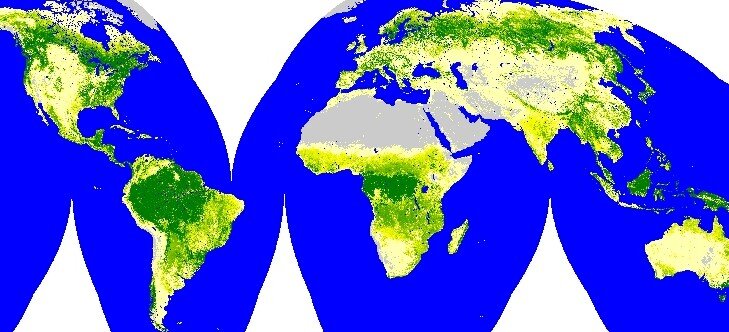
One of our primary interests is absorbed radiation, because this powers photosynthesis – this is really critical, because it drives the whole carbon assimilation process. So satellite-derived radiance maps are extremely useful to us. Satellites also provide a multitude of other relevant information types: forest extent, land cover and land use change, soil moisture, snow cover, fire events and damage, biomass and forest age, multispectral information on plant properties from sensors like Envisat's MERIS (Medium Resolution Imaging Spectrometer), and atmospheric measurements of gases like methane.
Up to now, radar data have not played a major part in the Centre’s programme, but I expect this to change when the JAXA PALSAR goes into space later this year. This is because the longer wavelength of PALSAR gives more information about forests than the C-band SARs on ERS and ASAR. That said, one of the big achievements of ESA's ERS missions was to map forest biomass across Central Siberia, using a technique called SAR Interferometry (InSAR) to combine radar images from the twin spacecraft while they were flying in tandem. And there’s no doubt we could do a lot more that’s relevant to carbon with ERS and ASAR, given sufficient effort and resource.
I’m also hoping that at least one carbon-specific mission will come out of ESA's latest Earth Explorer call for ideas, although the thing about carbon is that, because it cuts across so many apparently different areas, even a mission focused on other scientific topics may be useful – for instance, the water and carbon cycles are intimately intertwined.
How easy is it to combine your models with real observational data?

In some of our models with simplified representations of carbon processes, using some satellite data is easy – ingesting data is how they operate – but they may not give the best estimates of carbon flux. In contrast, we have models that contain the best possible representations of carbon processes, but getting them to work with data is much harder. Few space measurements can be used directly in these carbon models, and it needs people who understand both the data and the models to bring the two together in a way that's meaningful. I’ve already said that many sorts of space data can help us, but each type involves serious effort to turn it into information relevant to the carbon models. Which types we focus on at any time depends on our judgement of how best to use our most important resource, the Centre research staff and PhDs.
I should add that I would like to see ESA going further not only to make its satellite data widely available but also to present it in a way that is suited to a broader scientific community. Whereas atmospheric science is full of people happy to work from raw data, the ecological community does not have this hard core of mathematicians and physicists. Ecologists are also dealing with quantities that are rather more complex than gas concentrations and temperatures. They have to take a different approach when integrating data into their models. There is tremendous scope for providing this community with higher-level products. This would greatly increase their use of Earth Observation data. With this approach I would expect the ecological community to make extensive use of ESA's MERIS sensor data in particular.
You’ve been attending ESA's Carbon from Space Workshop in Italy on 6-8 June?
It's been really useful and interesting. The meeting has been covering many of the issues involved in making Earth Observation data talk to carbon models. A main topic is the prospects for directly observing atmospheric carbon dioxide from space, which is likely to revolutionise our ability to measure and understand the carbon cycle. It also looks at the wider issue of how we can fit different sorts of space information from the atmosphere, ocean and land, into understanding the carbon cycle.
Is the answer to climate change simply to plant lots more trees?
Unfortunately not – to put it bluntly, we have to emit less carbon. Research shows that new forests don't become an instant sink of carbon. In fact, depending on where you plant them and the soil type and how you treat the ground, you may actually emit huge amounts of carbon while you're getting a new forest started. It can take 15 to 20 years for a forest stand to get to a carbon neutral point, after which you get a net carbon gain – but even if you planted the whole world with trees, once you've got mature forests across the globe, then that's it – you can soak up carbon for a certain amount of time, but then it saturates. Even in a warmer, more carbon-rich atmosphere where plants grow more abundantly, there's a physiological limit to their carbon absorption. All you are doing is buying time while you try and find a real solution, which involves weaning ourselves off carbon.
Otherwise we have to take the consequences of a world that's rapidly warming, and we don't really know what they'll be. Globally we have a pretty good idea, but regionally we certainly don't; for example, we can’t predict with any confidence what will happen to regional precipitation patterns.
What work are you carrying out as part of ESA's Dragon Programme?
Dragon allows me to make full use of my experience in radar. The project I’m working on is using Earth Observation to map land cover, agriculture and forestry in southwest China, with colleagues from the University of Fuzhou, and European partners Thuy Le Toan from CESBIO, Toulouse, and Mike Wooding from RSAC.
I’m also fortunate to have a visiting Chinese researcher, He Guojin, working with me in Sheffield for a year. He’s the Director of the Information Processing Department in the China Remote Sensing Satellite Ground Station, Beijing, and having him here has allowed the work go much faster and greatly eased communication with our Chinese partners.
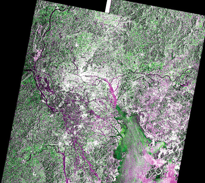
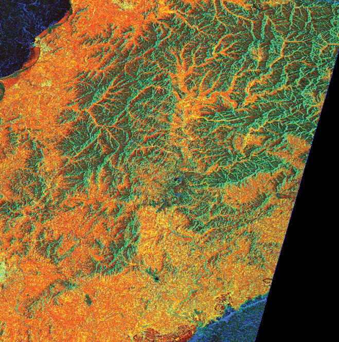
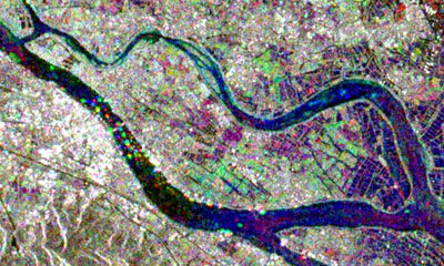
We first of all constructed a processing chain that takes advantage of dual-polarisation time-series data from the Envisat Advanced Synthetic Aperture Radar (ASAR) to reduce the speckle in the images and improve their interpretability. We are now using optical Landsat Thematic Mapper imagery and existing land cover maps to characterise and understand the radar signatures from different land cover types.
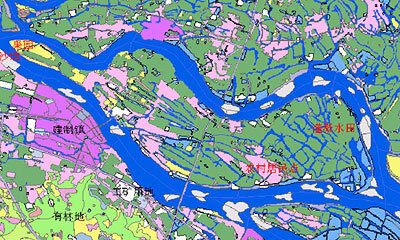
By discovering what drives the radar signal response and learning the signatures of different land covers, we will then develop classification algorithms that can be applied both to our region and more generally across China and similar subtropical areas. We're also particularly looking forward to discriminating the development of the seasonal rice crop using multi-temporal and polarised ASAR images.
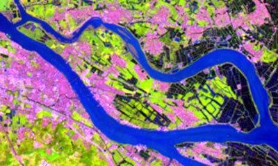
It is obvious from the radar and optical data that the Chinese maps are out of date for the area that we're looking at, but using the radar and optical imagery together you get a good understanding of what the land cover actually is.
One of the issues about exploiting radar data is that you see more information, which can be good and bad. You might want a nice, smooth map that clearly demarcates agriculture, water, forests, etc. – that comes out in the optical image, because in some ways it's a simpler signal. Radar contains more detail, because it is more responsive to a greater range of environmental effects. The fact that radar isn't affected by cloud is a big advantage, as this means one can guarantee getting an image if the radar is switched on. This means, for example, that forests can be distinguished from other types of vegetation using their temportal stability in the radar images, while this distinction does not emerge from the optical imagery.
For me, a key element of the Dragon Programme is the transfer to China of European know-how about how to get the information we want from radar data. As one aspect of this, Guojin and I have made available and implemented the optimised SAR processing chain at Fuzhou. And while the Dragon project is not strictly carbon-related, the collaboration has spawned a proposal to establish a project looking at carbon sequestration in subtropical areas. If this comes off, then it moves this work bang into the middle of my main research area, which is a very welcome and unexpected spin-off from Dragon.
Are you attending the next Dragon Programme symposium?
Yes – it is taking place on the island of Santorini from 27 June to 1 July. Attending helps set our own Dragon work in a larger context, and learn more about what the other 14 European-Chinese teams are doing, in the fields of the atmosphere and ocean as well as land.
The symposium is the first one hosted by ESA's new member state Greece, and should be a useful opportunity to meet the Chinese Earth Observation community; I'm told this will be the largest scientific delegation in the Earth Observation field ever to venture outside China for cooperation purposes. I hope to meet many potential future colleagues.