Envisat and UV forecasting
There can be few who do not know of the Sun’s potential to harm. Health experts warn that excessive exposure may cause cataracts and skin cancer. Ultraviolet radiation is, of course, the culprit, and animal studies even suggest that high levels of UV-A can weaken the immune system.
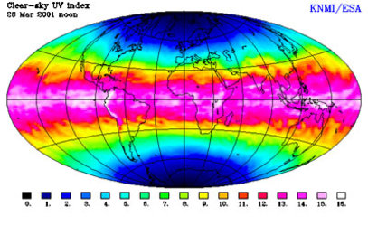
Luckily, Earth’s ozone layer - in the stratosphere some 40-kilometres high - protects the surface from most solar UV radiation. But damage to this “shield” means that more UV radiation now reaches the ground than in the past.
As a result, health authorities need to prepare strategies to combat the threat that excessive UV radiation poses to public health. Whether it is tourists holidaying on the Cote d’Azur or officials from the World Health Organisation (WHO), administering a vaccination programme in, say, sub-Saharan Africa, there is a need for knowledge of UV radiation levels and forecasts.
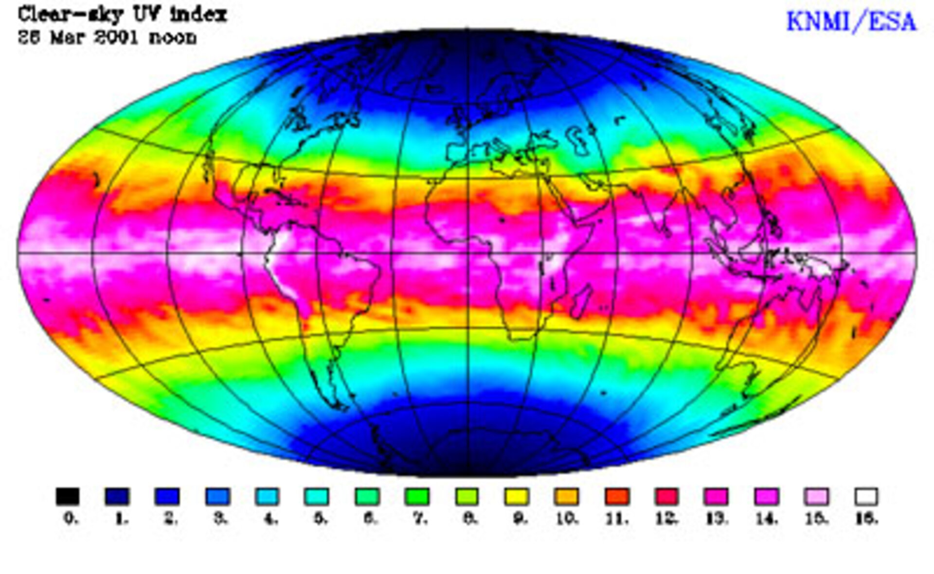
In a classic example of satellites and computers working together, ACRI, a French-based company, will work with data from ENVISAT’s instruments (MERIS, GOMOS, MIPAS and SCIAMACHY) to develop predictions of UV levels for 1-6 days ahead and to create a database of global UV indices.
The forecasting models will enable authorities to warn people to take precautions if the UV index is expected to be high. While the global indices should help epidemiologists at the WHO to understand the health consequences associated with different UV indexes. Armed with such information, WHO can prepare appropriate preventative and therapeutic public health strategies.
Already, ACRI has completed much of the technical development of the two computer models needed to produce the UV forecasts. Three types of satellite data are needed – ozone concentrations in the stratosphere, cloud coverage and aerosols in the lower atmosphere. Both ESA (ERS 1 and 2) and NASA satellites supply ACRI with ozone concentrations, but GOMOS , MIPAS and SCIAMACHY will provide even more detailed knowledge of the ozone layer, whilst MERIS will provide details on the aerosols and the type and extent of clouds in the troposphere.
ACRI has already evaluated how UV index data could be disseminated on the ground as part of a pilot project around the Mediterranean funded through the European Commission’s Ten Telecoms programme. And the company’s work on global UV indices will contribute to a much larger programme, called INTERSUN, that the WHO, the World Meteorological Organisation (WMO), the United Nations Environment Programme (UNEP), the International Agency on Cancer Research (IACR) and the International Commission on Non Ionizing Radiation Protection (ICNIRP) are sponsoring.