Envisat and the West Antarctic Ice Sheet
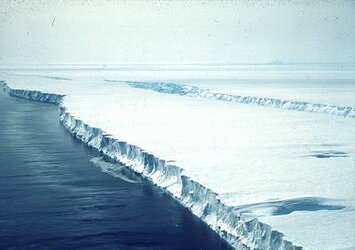
The West Antarctic ice sheet (WAIS) is undergoing rapid changes. As yet no one fully understands the reasons for these, but if the WAIS were to collapse, it would raise sea levels by about five metres.
Not surprising, then, that scientists want to know how the ice-shelves and ice streams that make up the ice sheet are behaving. Only with detailed knowledge of how the ice sheet interacts with the oceans, atmosphere and land will it be possible to predict the future of the WAIS.
Envisat’s Synthetic Aperture Radar and Radar Altimeter is helping scientists from the British Antarctic Survey to study two critical aspects of the WAIS: first, where the edge of the ice streams are in the ice shelf, and, secondly, how fast these are flowing and thinning. Only satellites can survey these remote regions.

Already instruments on ESA’s ERS-1 and ERS-2 satellites have shown that one glacier in the WAIS – the Pine Island Glacier – has retreated 5 km inland as a consequence of ice thinning. When these results were published in Science in February, 2001, Dr Andrew Shepherd from University College London, said: “It is of paramount importance to determine whether the thinning is accelerating. Our present theoretical understanding is not sufficient to firmly predict the future evolution of Pine Island Glacier.”
Envisat’s instruments have the capabilities to add observations important for developing predictions of the behaviour of the WAIS.
Further reading:
Shepherd, Andrew et al, Science, 291, 862-864, February 2, 2001