

'Eyes' in space check shrimp farms
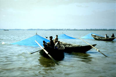
Shrimps with salad, shrimps with pasta, shrimps with pizza, potted shrimps with toast - if this delicacy has now become fairly common we have the shrimp farmers in Europe, South America and particularly Asia to thank. In the future thanks will also be due to satellites and the important remote sensing data that they provide on aquaculture.
Shrimp farming is a thriving business. According to the Food and Agriculture Organization (FAO) aquaculture production has increased rapidly in the past decade while seafood production has remained relatively stable - and shrimp farming is one of the fastest growing sectors of the aquaculture industry.
Although shrimp farms can be found all over the world, the main cultured shrimp-producing countries are in Latin America and Asia, and the main markets are the United States, Japan and Europe. In value terms, shrimps are the most important seafood product traded internationally.
As often happens, however, its rapid development has been accompanied by controversial debates over the environmental, social and economic impact of shrimp farming. Often, government planning and regulatory frameworks have been unable to keep pace with the rapid rise in shrimp farms. Care is needed to ensure that private returns on shrimp culture can be sustained and to preserve the local environments of mangroves, creeks and lagoons; coastal water quality; and wild shrimp stocks. This is where ESA and the remote sensing data supplied by its satellites can help out.
A few years ago ESA, FAO and the Government of Sri Lanka worked together on a remote sensing study to protect and improve shrimp farming. Outbreaks of disease had badly hit the shrimp farmers and one of the causes was thought to be the uncontrolled proliferation of the farms, which had damaged the environment. What was needed was precise regular mapping of the shrimp farms to register their increase and growth, and to monitor encroachment onto reservation areas.
ESA’s Earth Remote Sensing satellites are continually orbiting around the Earth allowing the equipment onboard to provide constant data, in all weather, on our environment. One of these instruments is called a synthetic aperture radar (SAR). This data covers an area of 100 km2 and collects information on the same place on Earth, normally at regular intervals of every 35 days.
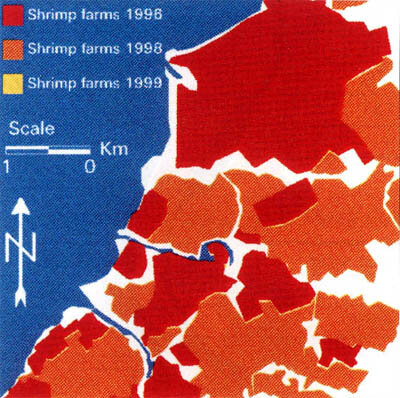
By comparing SAR data of the selected shrimp farming area in Sri Lanka for the last few years, and then developing the methodology to identify and quantify the surface area enclosed by shrimp farms, it was possible to assess their growth and to monitor their development. Once the satellite data had been interpreted, a random field survey was undertaken to check the accuracy of the methodology.
The results were extremely encouraging as the data proved to be more than 90% accurate. The satellite data showed that in three years the area covered by shrimp farms had increased by more than 44%. The high resolution of the SAR data made it possible to pinpoint the areas in which the growth had been most rapid and the remote sensing results showed that the growth had been much greater than estimates carried out by traditional means had led the authorities to believe.

As this was the first time that SAR data had been used to inventory and monitor shrimp farms the most demanding part of the study was to develop the methodology to interpret the data. However, now that this has been developed it is can easily be used in other areas.
A further advantage was that the survey found the cost of using satellite data to be relatively modest in comparison to that of aerial photography. The latter also has the drawback of being more difficult to obtain and being unavailable in cloudy weather – a condition common in tropical and subtropical areas.
Given the positive results of the Sri Lanka study carried out with ESA’s help, FAO prepared a regional project for the inventory and monitoring of coastal and inland aquaculture which it is hoped will come into operation in 2002. India, Indonesia, Malaysia, the Philippines, Thailand and Vietnam have all requested to take part in this study. An important feature of the project will be to train local personnel in the use of the methodology developed in Sri Lanka so that they will be able to interpret the satellite data for themselves.
Carlo Travaglia of FAO’s Environment and Natural Resources Service expects the number of shrimp farms, as well as other forms of aquaculture, to continue to grow over the next two decades. “A large percentage of global production comes from small producers living in developing countries. Satellites and shrimps are a strange combination but one that is contributing to increasing food security, alleviating poverty and safeguarding our environment”.
