• → European Space Agency

      • Space for Europe
      • Space News
      • Space in Images
      • Space in Videos
    • About Us

      • Welcome to ESA
      • DG's News and Views
      • For Member State Delegations
      • Business with ESA
      • ESA Exhibitions
      • ESA Publications
      • Careers at ESA
    • Our Activities

      • Space News
      • Observing the Earth
      • Human Spaceflight
      • Launchers
      • Navigation
      • Space Science
      • Space Engineering
      • Operations
      • Technology
      • Telecommunications & Integrated Applications
    • For Public

    • For Media

    • For Educators

    • For Kids

    • ESA

    • GOCE

    • Earth Explorers

    • Observing the Earth

    • Living Planet

    • GOCE at a glance
    • The first of a series
    • Looking into the forces that shape our planet
    • A technological achievement
    • An intimate portrait of Earth
    • Facts and figures
    • About the spacecraft

      • Satellite
      • Payload
    • About the launch

      • Launch overview
      • Launcher
      • After launch
      • GOCE data
    • Meet the team

      • Danilo Muzi, Project Manager
      • Rune Floberghagen, Mission Manager
      • Reiner Rummel, Chairman Mission Advisory Group
      • Mark Drinkwater, Mission Scientist
      • Roger Haagmans, Mission Scientist
      • Andrea Allasio, Thales Alenia Space Project Manager
      • Michael Fehringer, System Manager
      • Paolo Laberinti, Head of Verification and Testing
      • Miguel Aguirre, Technical Officer for Definition Phase
      • Daniel Lamarre, Gradiometer Engineer
      • Juan Piñeiro, Spacecraft Operations Manager
      • Stefano Capitanio, Launch Campaign Manager
      • Pascal Gilles, Head of Earth Explorer Payload Data Ground Segment
    • Multimedia
    • Image gallery
    • Videos
    • Online resources

    ESA > Our Activities > Observing the Earth > GOCE

    Workshop on Earth Gravity Field from Space

    Surface gravity data, GOCE satellite gravity gradients and digital topography
    3 April 2002

    Following the success of the first International GOCE User Workshop at ESTEC in 2001, the Workshop on Earth Gravity Field from Space was held from 11-15 March 2002 at the International Space Science Institute (ISSI) in Bern, Switzerland.

    The ISSI invited some 50 experts acknowledged in their fields to discuss the impact of new, improved satellite gravity measurements on the following:

    • Strategies for ultra precision orbit determination and gravity field modelling
    • Solid-earth physics
    • Ocean circulation
    • Geodesy
    • Sea level
    • Development of future gravity mission concepts

    The meeting attracted a variety of presentations based on recent results from processing CHAMP (German/US) satellite data, as well as research in preparation for Grace (US/German satellite gravity mission 2002-2006) and GOCE (ESA’s first Core Earth Explorer mission) data.


    Attendees agreed that the workshop had been a success in that they had achieved important synergistic results in utilising satellite gravity data, combined with terrestrial observations and computer models, to better describe processes in the Earth’s interior, oceans and atmosphere.

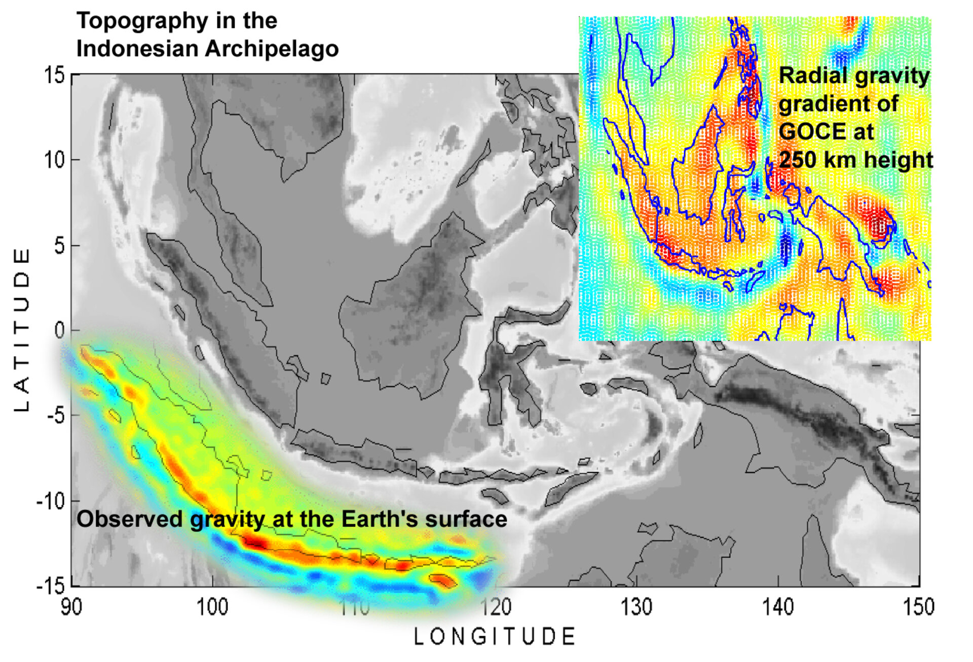
    For example, better seasonal climate forecasting is expected when improved geoid data (the reference of equal gravitational potential energy around the Earth) from GOCE can be combined with ocean profiling float data in ocean models. Also, a better understanding of the processes involved in tectonically active regions of the world is anticipated, which may help with earthquake forecasting. This is due to the way in which high-resolution gravity anomalies and time-varying gravity data can be combined with seismic tomography data to improve two-dimensional models of the lithosphere and upper mantle (see figure above). In addition, the same high-resolution gravity measurements help to improve corrections for post-glacial rebound and isostatic adjustment when assessing global sea-level rise using satellites such as ENVISAT and CryoSat. This refers to the fact that during periods of glaciation the weight of thick ice-sheets causes the Earth’s crust to sink, for example during the last Ice Age Scandinavia was depressed several hundred metres. When the ice-sheets melt the Earth’s crust begins to rise again. Although it takes thousands of years to reach isostatic equilibrium, the uplift is associated with a local fall in sea level.

    Kluwer Academic Publishers is to publish a book, which will contain the results of the papers presented at the workshop. Also a second workshop is planned for 2004 to further exploit the synergies between the various science disciplines involved.

    Rate this

    Views

    Share

    • Currently 0 out of 5 Stars.
    • 1
    • 2
    • 3
    • 4
    • 5
    Rating: 0/5 (0 votes cast)

    Thank you for rating!

    You have already rated this page, you can only rate it once!

    Your rating has been changed, thanks for rating!

    13
    Tweet
    • Related articles
    • CryoSat
      • What is Envisat?
        • Gravity field quantities
        • Related links
        • ISSI Workshop
        • First international GOCE user workshop
        • CHAMP
        • GRACE

    Connect with us

    • RSS
    • Youtube
    • Twitter
    • Flickr
    • G+
    • Facebook
    • Livestream
    • Subscribe
    • App Store
    • LATEST ARTICLES
    • · Proba-V opens its eyes
    • · First new Galileo satellite arrive…
    • · Next destination: space
    • · Leak repaired on International Spa…
    • · After Chelyabinsk: European expert…
    • FAQ

    • Jobs at ESA

    • Site Map

    • Contacts

    • Terms and conditions