Satellites map Earth’s vital resources
Recent studies show that satellite radar data can be exploited to map forest height, 3D forest structure and their natural or anthropogenic disturbance with high spatial resolution and accuracy.
Since forests assist in removing carbon dioxide from the atmosphere, this could prove to be an important tool for assessing carbon stocks and monitoring our planet’s resources.
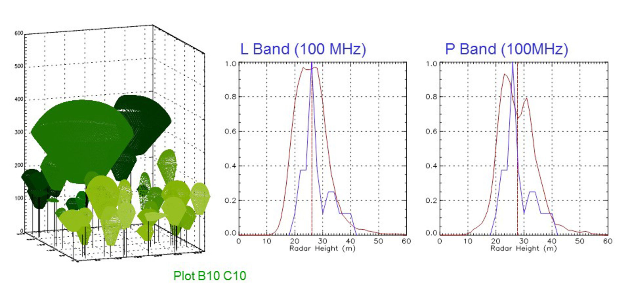
Polarimetric InSAR – or Pol-InSAR – is a remote sensing technique based on polarimetric information in Synthetic Aperture Radar (SAR) images.
With this technique, a radar sends polarised pulses towards the target, and the information in the signals backscattered from Earth can be used to infer properties of the target area.
By using two polarimetric SAR images over the same area, acquired from slightly different angles, information on the 3D structure of the area can be extracted.
By deriving information on the tree canopy height and vertical structure, forest biomass can be estimated. The biomass of places like tropical forests are crucial for storing carbon, and large areas could be mapped very accurately using this technology.
In recent years, the potential of Pol-InSAR techniques for the estimation of forest structures has been addressed, developed and matured through various ESA-funded research and development studies.

In the Pol-InSAR Mission and Applications Study, scientists addressed the performance issues critical to the evolution of forest product generation to a pre-operational level using Pol-InSAR.
Scientists first assessed the performance of Pol-InSAR over tropical forest environments on the Indonesian island of Borneo.
Tropical ecosystems have enormous ecological importance owing to their ability to store carbon and subsequent effect on the carbon cycle. Mapping these forests in 3D is important for assessing carbon stocks and monitoring our planet’s resources.
By comparing tree height calculations derived using Pol-InSAR techniques to the results from ground measurements, the scientists found that the former technique can provide estimations within 90% of a given area’s biomass.
Another result of the study was the validation of the Pol-InSAR technique’s ability to estimate a forest’s top height at high spatial resolutions.
Forest height maps of southern Germany’s Traunstein forest were produced using Pol-InSAR data from both 2003 and 2008. Comparing the two maps, changes were evident. The maps clearly showed areas where the logging of individual tall trees occurred, while damage caused in January 2007 by the hurricane Kyrill, which blew down large parts of the forest, were visible. Forest growth was also evident.