
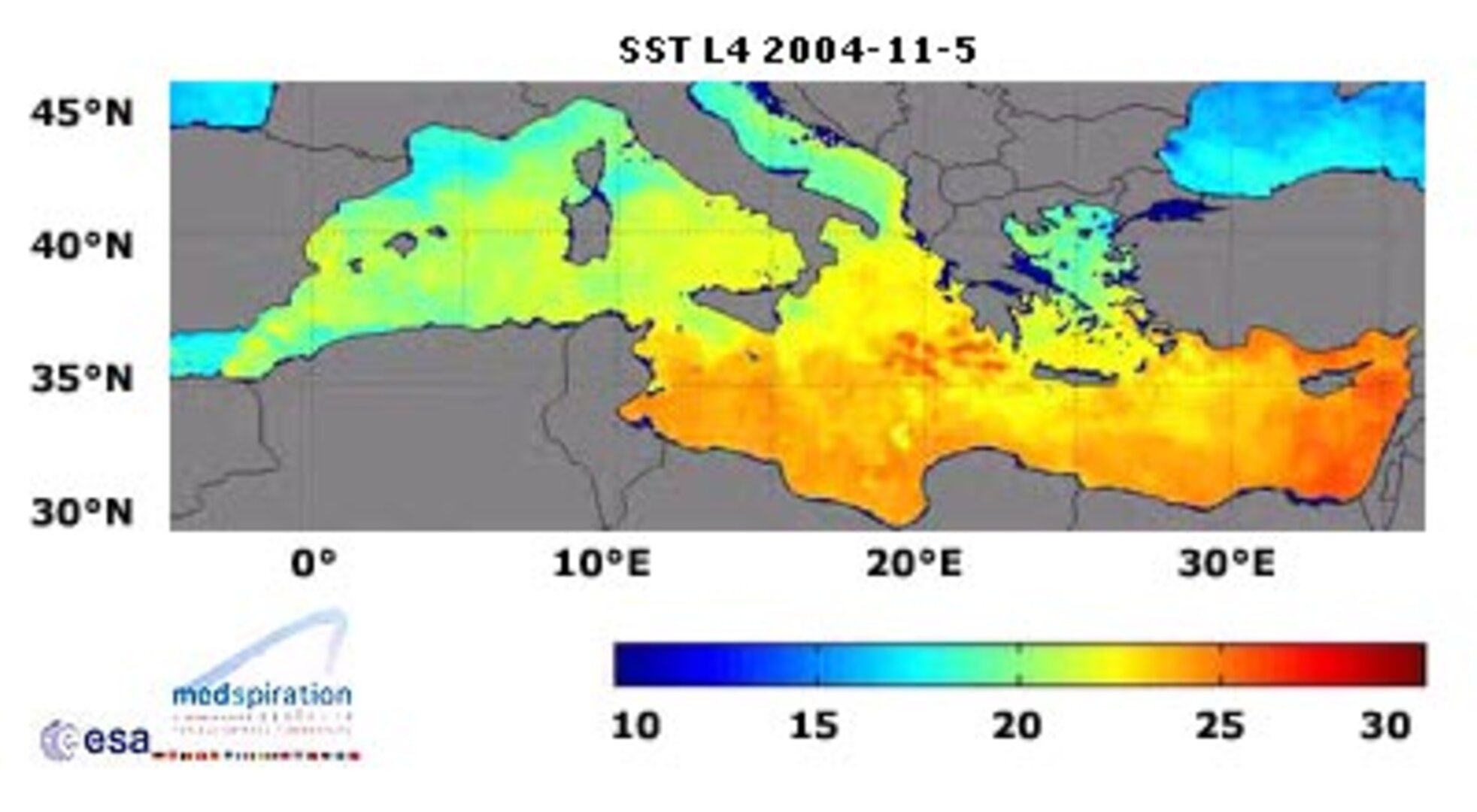
Satellites plus software equal best-ever Mediterranean heat map
This ultra high-resolution sea surface temperature map of the Mediterranean could only have been made with satellites. Any equivalent ground-based map would need almost a million and a half thermometers placed into the water simultaneously, one for every two square kilometres of sea.
This most detailed ever heat map of all 2 965 500 square kilometres of the Mediterranean, the world's largest inland sea is being updated on a daily basis as part of ESA's Medspiration project.
With sea surface temperature (SST) an important variable for weather forecasting and increasingly seen as a key indicator of climate change, the idea behind Medspiration is to combine data from multiple satellite systems to produce a robust set of sea surface data for assimilation into ocean forecasting models of the waters around Europe and also the whole of the Atlantic Ocean.
For the Mediterranean Sea, the Medspiration product is being created to an unprecedented spatial resolution of two square kilometres, as Ian Robinson of the Southampton Oceanography Centre, managing the Medspiration Project explains: "The surface temperature distribution in the Mediterranean contains many finely detailed features that reveal eddies, fronts and plumes associated with the dynamics of water circulation. A resolution as fine as this is needed to allow these features to be properly tracked."
The remaining ocean products are intended to have a still impressive spatial resolution of ten square kilometres. Overall results from the Medspiration project also feed into an even more ambitious scheme to combine all available SST data into a worldwide high-resolution product, known as the Global Ocean Data Assimilation Experiment (GODAE) High-Resolution Sea Surface Temperature Pilot Project (GHRSST-PP).
Its aim is to deliver to the user community a new generation of highly accurate worldwide SST products with a space resolution of less than ten kilometres every six hours.
As an important step towards achieving this goal, ESA has not only initiated Medspiration as the European contribution to the overall GHRSST-PP effort, but the Agency funded a GHRSST International Project Office, located at the Hadley Centre for Climate Prediction and Research, a part of the UK Met Office located in Exeter.
"Medspiration is at the forefront of the GHRSST-PP effort and is driving the operational demonstration of GHRSST-PP as an international system," says Craig Donlon, head of the GHRSST Office. "GHRSST has developed with a 'system of systems' approach, demanding stable interfaces and comprehensive data handling and processing systems.
"Medspiration is ready to deliver the European component of GHRSST-PP. Over the next 12 months Medspiration will play a fundamental role in partnership with other operational groups in the USA, Australia and Japan as the GHRSST-PP system begins the operational delivery of a new generation of SST data products to European and international user communities in near real time."

The temperature of the surface of the ocean is an important physical property that strongly influences the transfer of heat energy, momentum, water vapour and gases between the ocean and the atmosphere.
And because water takes a long time to warm up or cool down the sea surface functions as an enormous reservoir of heat: the top two metres of ocean alone store all the equivalent energy contained in the atmosphere.
The whole of their waters store more than a thousand times this same value – climatologists sometimes refer to the oceans as the 'memory' of the Earth's climate, and measuring SST on a long-term basis is the most reliable way to establish the rate of global warming.
Like thermometers in the sky, a number of different satellites measure SST on an ongoing basis. For example, the Advanced Along-Track Scanning Radiometer (AATSR) aboard ESA's Envisat uses infrared wavelengths to acquire SST for a square kilometre of ocean to an accuracy of 0.2 °C. In fact, thanks to its high accuracy, AATSR is helping to calibrate other sensors employed by the Medspiration project.
Other satellites may have decreased accuracy or resolution, but potentially make up for it with cloud-piercing microwave abilities or much larger measuring 'footprints'. Combine all available satellite data together – along with localised measurements from buoys and research ships - and you can achieve daily monitoring of the temperature of all the oceans covering 71% of the Earth's surface. This information is then prepared for input into the relevant 'virtual ocean' – a sophisticated computer model of the genuine article.
The combination of satellite and also available in-situ observations with numerical modelling – a technique known as 'data assimilation' – is an extremely powerful one. It has revolutionised atmospheric weather forecasting and is now being applied to the oceans.
Near real time observational inputs keep an ocean model from diverting too much from reality, while the outputs from the model make up for any gaps in coverage. With maximised coupling between actual observations and the numerical model, output data can be credibly used for operational tasks such as sea state and algal bloom forecasting, and predicting the path of oil spills. And these models can also be used to look deeper than just the ocean surface.
"The time is coming for operational monitoring and forecasting of three-dimensional global ocean structure," comments Jean-Louis Fellous, Director for Ocean Research at France's IFREMER, the French Research Institute for Exploitation of the Sea, a Medspiration project partner. "A project like Medspiration is a key contribution to this endeavour.
"With the capabilities offered by spaceborne SST sensors, by satellite altimeters and by the 1,500 profiling floats measuring temperature and salinity in the deep ocean – and all this data being fed in near-real time to global ocean models, this vision is becoming a reality."

Although the new map of the Mediterranean represents an important step forward, both Medspiration and GODAE GHRSST-PP remain works in progress at this point.
The main problem with monitoring high-resolution SST of the Mediterranean is cloud cover. To compensate the team has available a near real time data stream from four separate satellites – two European, one American and one Japanese. Also applied is a technique called 'objective analysis' that minimises cloud effects by interpolating values from just outside the obscured area or from that area measured at times before or after cloud covered it.
Mixing satellite data together on a routine basis is fraught with difficulty because the thermal structure of the upper ocean is actually extremely complex, and different sensors may be measuring different values. There is also considerable day-to-night variability, with daytime temperatures varying with depth much more than those during the night.
Part of the aim of Medspiration is to fully account for this diurnal cycle, in order to improve the overall effectiveness of its data assimilation into ocean forecasting models.


