Experts to discuss Earth observation for geo-hazards
Natural hazards – like earthquakes and landslides – put people and places at risk every day, but satellites are able to help improve safety and mitigate these risks.
International experts will meet next month to discuss how space-based technology can help us prepare for and respond to disasters.
Organised by ESA in association with the Group on Earth Observations (GEO), the International Forum on Satellite Earth Observation for Geohazard Risk Management will be held on 21–23 May at the Santorini Convention Centre in Greece.
The forum is open to geo-science users and experts working in the field of geo-hazard risk assessment and management. This includes representatives from space agencies and value-adding industries, as well as Earth observation mission owners/operators and users such as risk management authorities, land planning and risk prevention service providers and infrastructure managers.
Invited speakers from national and international entities such as the GEO, the Institute of Geology of the China Earthquake Administration, the United States Geological Survey and the Italian Department of Civil Protection will participate in the meeting.
They will discuss their experience and ideas concerning the use of satellite Earth observation with the aim of contributing to the understanding, mitigation, preparedness and management of geophysical risks.

Satellites play a key role in the assessment and management of geo-hazards such as earthquakes, volcanoes and landslides, as well as subsidence of cities and deformations of flood defence structures in coastal lowlands.
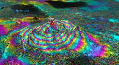
For example, one Earth observation technique, called interferometry, is often used to map terrain deformations, such as those that can occur before a volcanic eruption.
Interferometry involves comparing two or more radar images of the same location in order to take precise measurements of the ground motion that has occurred between the acquisitions – down to a scale of a few millimetres.
Many other Earth observation techniques can contribute to geo-hazard risk management such as volcanic ash monitoring using atmospheric remote sensing.
With the Sentinel family of satellites being developed under the Global Monitoring for Environment and Security (GMES) programme, a wealth of data and products will become available to meet better the needs of the users involved in the assessment and management of geo-hazard risks.

Sentinel-1 will be a key source for systematic terrain deformation monitoring for all types of geo-hazards, while Sentinel-2 will provide high-resolution multispectral imagery to support asset mapping and hazard mapping for a broad range of hazard types.
Sentinel-3 will provide thermal-infrared imagery with high temporal sampling to support lava flow monitoring.
The event in Santorini will be an opportunity to discuss the requirements for Earth observation missions and consolidate a roadmap for the development of applications to support geo-hazard users and practitioners.
In addition, an Industry Session on future perspectives concerning industrial services will serve as an opportunity to consult with leading players from the Earth observation sector such as mission operators and data and service providers.
Following the International Forum on Satellite Earth Observation for Geohazard Risk Management, a scientific and technical report will be released as a joint ESA-GEO publication.