World Ocean Day: how satellites safeguard our waters
Earth's oceans are what make this a Blue Planet. Our seas influence the climate, produce most of the oxygen we breathe, serve as a means of transport and a major source of food and resources. Today's World Ocean Day is a chance to learn more about the seas that surround us – and how satellite monitoring helps protect them.
Wednesday 8 June is the 13th annual World Ocean Day. Created in 1992 at the Earth Summit at Rio de Janeiro, World Ocean Day is an opportunity to celebrate our world ocean, its abundant life, and the ways we are all connected to the sea, no matter how far we live from its edge. More than 600 aquariums, zoos, museums and conservation organisations are participating in global activities today.
The ocean is no longer so abundant and clean as it once was: many of the world's fisheries are in decline, coral ecosystems are deteriorating and fragile coastal habitats being choked by pollution. But today and every day, Earth Observation spacecraft continuously acquire data across the seven tenths of our planet covered by the sea.
These data increase our scientific understanding and support a range of environmental monitoring services in support of ocean conservation.
Global ocean temperature measurements
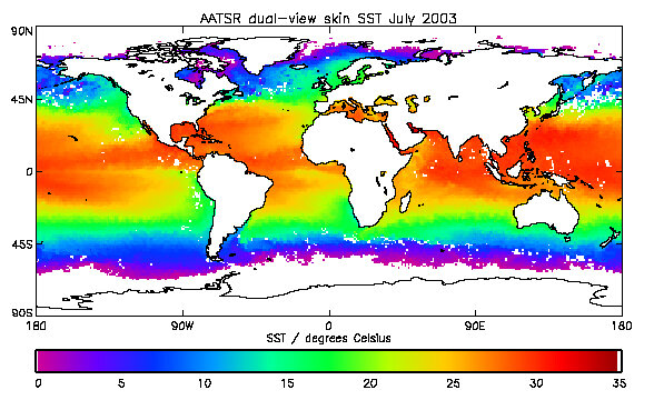
Space-based instruments measure sea surface temperature, which is important because it helps improve weather forecasting and is also a key indicator of the likely extent of future climate change – the oceans working like batteries that store incoming solar energy.
For example, the family of Along Track Scanning Radiometer (ATSR) sensors carried on ESA's ERS and Envisat satellites have compiled a continuous dataset of ocean temperatures that stretches back 14 years that could be used to prove a heating trend beyond the range of natural variation.
An ambitious plan aims at merging all available sea surface temperature data including satellite sources into a worldwide high-resolution product known as the Global Ocean Data Assimilation Experiment (GODAE) High-Resolution Sea Surface Temperature Pilot Project (GHRSST-PP).
The European component of this global effort is an ESA activity called Medspiration, producing daily-updated high-resolution heat maps of European waters including the Mediterranean Sea.
Three-dimensional ocean mapping

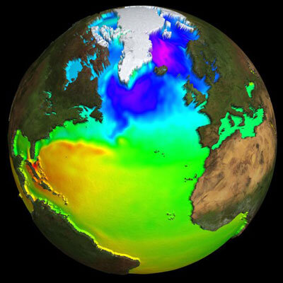
The ever-changing topography of the ocean is also monitored from orbit. Radar imagery and scatterometer data reveal ocean waves and sea surface wind fields. Sea surface height is acquired with the Radar Altimeter (RA) family of sensors - as carried aboard the ERS and Envisat spacecraft - which function by measuring the precise time a radar pulse takes to bounce back to its satellite.
The French firm CLS (Collecte, Localisation Satellites), with support from French space agency CNES, processes altimetry data from the satellites ERS-2, Envisat, GFO, TOPEX/Poseidon and Jason-1 in the frame of a project called SSALTO/DUACS (Segment for ALTimetry, Orbitography and precise localisation/ Developing Use of Altimetry for Climate Studies). Mercator Ocean, the French contribution to GODAE, assimilates those data in its three-dimensional forecasting model of the global ocean, updated weekly.
Slight centimetre-scale height variations in sea height provide information on ocean currents and temperature – warm currents can stand around half a metre higher than colder surrounding waters – plus salinity, the current surface state, the underlying bathymetry of the seabed and even variations in the planet's gravity field.
Additional, operational applications include marine routing, ensuring safety at sea, laying marine cables and optimising fishing fleet performance.
Altimetry also provides authoritative global measurements of sea level change – one of the most important ocean-related variables, because a large enough upward shift (due to polar melting or other factors) might erode human habitats and alter the very face of our planet. The evidence from space so far suggests a steady average rise of 0.3 millimetres a year.
Monitoring water quality
With around a third a third of EU territory covered by seas, the ocean is an important area of activity within Global Monitoring for Environment and Security (GMES) - a joint initiative of ESA and the European Union (EU) to integrate all available space- and ground-based information sources to yield accurate portraits of the current state of our planet.
ESA's initial portfolio of Earth Observation-based services known as the GMES Services Element (GSE) includes a focus on water quality monitoring, with a focus on two important applications: the detection and tracking of oil spills – both chemically and physically hazardous to the marine environment - and forecasting toxic algae blooms, which threaten costly contamination of Europe's growing aquaculture – fish or shellfish farming - industry.
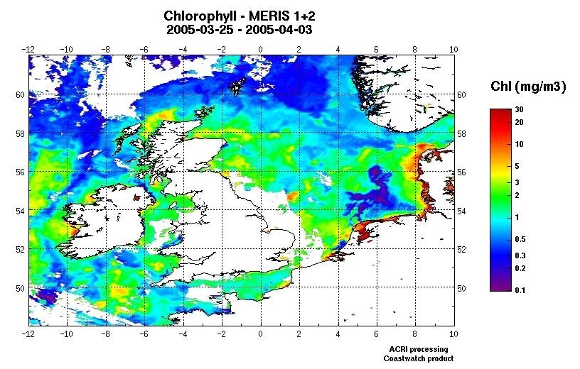
Ocean colour satellite sensors such as Envisat's Medium Resolution Imaging Spectrometer (MERIS) can reveal a lot about the contents of seawater: the ocean tint seen from space can be run through specialised algorithms to pinpoint its suspended contents, including marine phytoplankton, sediment loading and pollution.
Identifying oil spills
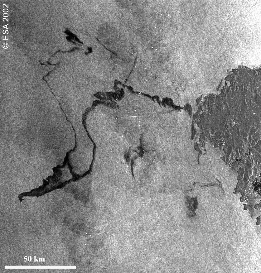
For detecting oil pollution, radar sensors such as Envisat's Advanced Synthetic Aperture Radar (ASAR) are effective. Oil has a dampening affect on the water it floats on, returning less signal backscatter to show up blacker in a radar image.
Radar surveillance of accidental oil spills has shown its worth repeatedly, notably during the Prestige tanker accident off Spain's Galician coast in November 2002. An Envisat image revealed the spill had split in two, providing a novel insight into the extent of coastline in danger.
However 90% of oil pollution at sea is not accidental but actually due to deliberate dumping. Systematic wide-area surveillance foreseen as part of GMES promises to help deter such illegal activity.