New radar satellite technique sheds light on ocean current dynamics
Ocean surface currents have long been the focus of research due to the role they play in weather, climate and transportation of pollutants, yet essential aspects of these currents remain unknown.
By employing a new technique – based on the same principle as police speed-measuring radar guns – to satellite radar data, scientists can now obtain information necessary to understand better the strength and variability of surface current regimes and their relevance for climate change.
Scientists at the SeaSAR 2008 workshop held this week in ESRIN, ESA's European Centre for Earth Observation in Frascati, Italy, demonstrated how this new method on data from the Advanced Synthetic Aperture Radar (ASAR) instrument aboard ESA’s Envisat, enabled measurements of the speed of the moving ocean surface.
Synthetic Aperture Radar (SAR) instruments, such as ASAR, record microwave radar backscatter in order to identify roughness patterns, which are linked to varying surface winds, waves and currents of the ocean surface. However, interpreting radar images to identify and quantify surface currents had proven very difficult.
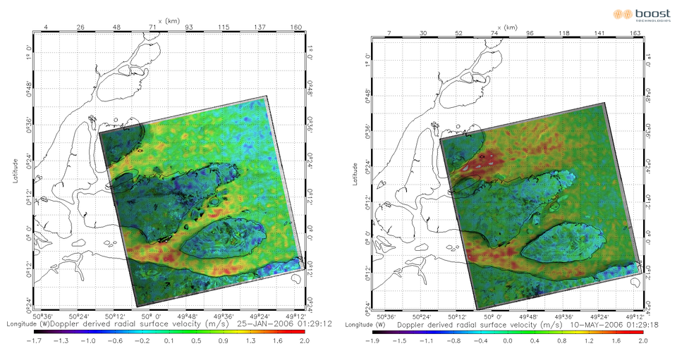
By using the new information embedded in the radar signal – the Doppler shift of the electromagnetic waves reflected from the water surface – Dr Bertrand Chapron of the French Research Institute for Exploitation of the Sea (IFREMER), Dr Johnny Johannessen of Norway’s Nansen Environmental and Remote Sensing Centre (NERSC) and Dr Fabrice Collard of France's BOOST Technologies were able to determine how surface winds and currents contribute to the Doppler shift.
The Doppler shift occurs due to changing relative velocities, experienced in everyday life in the way the pitch of a siren on a passing ambulance goes up as it approaches, then goes down as the vehicle recedes away.
The shift is introduced by the relative motion between the satellite platform, the rotation of the Earth and the velocity of the particular facets of the sea surface from which the SAR signal scatters back to orbit. The initial two values are well known – particularly for Envisat, with its very stable satellite orbit and attitude – and can be simply subtracted to extract the useful sea surface velocity information.
Chapron first demonstrated the concept in 2005 with initial tests carried out over the Gulf Stream. Although the results were promising, repeat acquisitions and careful validation were not possible. However, based on these conclusions ESA upgraded its ASAR ground segment in July 2007 to systematically process and disseminate a Doppler grid product, a regularly spaced collection of individual Doppler information, for all Wide Swath acquired images.
The Doppler grid, embedded in ESA standard products, is now regularly tested on a number of so-called super-sites, including regions of the Gulf Stream and the greater Agulhas Current, both among the strongest western boundary currents of the world’s oceans.
"These measurements are very useful for advancing the understanding of surface current dynamics and mesoscale variability, as well as for determining surface drift, important for oil dispersion and pollution transport and for wave-current interaction, probably influencing the existence of extreme waves," Johannessen said.
"The method at this very high resolution could also complement the use of additional information sources to improve 3-D ocean models. Its use for sensor synergy with radiometry, spectrometry and altimetry is very promising," Chapron added.
The ground segment upgrade is also allowing the scientists to examine the anticipated Doppler shift signal of the river outflow at the mouth of the Amazon delta to monitor river runoff and improve our understanding of hydrological processes.

Chapron and Collard also presented their Near Real Time global swell wave observations to the workshop, attended by 150 participants from 25 countries. Using standard processed SAR ESA wave mode products, the team produces three hourly animations every morning for the Atlantic, Pacific and Indian Oceans and makes them available online.
Tracking swell waves from space is very important because they are generally preceded by calm water, making it impossible to detect their arrival from shore. Envisat’s Wave Mode acquires 10 by 5 km small images, or 'imagettes', of the sea surface every 100 km along the satellite orbit. These small images, which depict the wave groups, are then mathematically transformed into wave energy and direction, called ocean-wave spectra.
ESA has provided SAR data to some 500 oceanography projects since 1998 and remains committed to providing continuity to its SAR missions. As part of its Global Monitoring for Environment and Security (GMES) programme, the agency will launch the Sentinels – the first series of operational satellites responding to the Earth Observation needs of GMES, a joint initiative of the European Commission and ESA.
Sentinel-1, expected to be launched in 2011, will ensure the continuity of C-band SAR data with ESA's ERS-2 and Envisat satellites. Important applications driving the mission concept include marine - vessel detection, oil spill mapping and sea ice mapping. With these new findings, Sentinel-1 is expected to provide additional information, such as consistent wind, wave and current products.