MERIS data on photosynthesis continues to prove accurate
Validation of Envisat's MERIS sensor is essential to establish its accuracy and consequently support the scientific communities interested by the quantitative use of data being delivered by this instrument. A sophisticated processing code developed by the European Commission's Joint Research Council (JRC) is proving invaluable for the on-going campaign for the validation of MERIS.
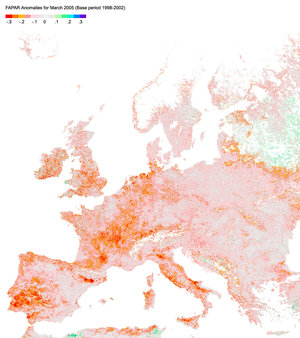
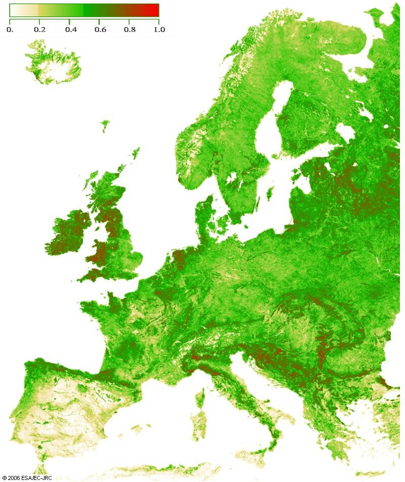
Envisat's Medium Resolution Imaging Spectrometer (MERIS) acquires multi-spectral imagery of the Earth. Although data from MERIS is primarily used for the measurement of ocean colour (data on which can be converted into a measurement of chlorophyll pigment concentration, suspended sediment concentration and aerosol loads over marine areas), it is also used to monitor the state and evolution of the Earth's vegetation cover. In particular, the MERIS Global Vegetation Index (MGVI), which corresponds to the Fraction of Absorbed Photosynthetically Active Radiation (FAPAR), is generated operationally as a standard product using the radiation measured by MERIS over land surfaces. This bio-geophysical product plays a critical role in the plant photosynthetic process and is regularly used in diagnostic and predictive models to compute primary productivity of the vegetation canopies. FAPAR has been established as a fundamental surface parameter by international organisations including the Global Climate Observing System (GCOS), charged with providing data on the Earth's climate system.
A group of scientists from the Institute for Environment and Sustainability - part of the European Commission's Joint Research Centre (EC-JRC), is responsible for the design and development of the MGVI processing code as well as for the validation of the product. This validation exercise is an on-going activity, conducted in parallel for a series of FAPAR related algorithms developed at JRC and tailored to other satellite sensors, including NASA's MODerate Instrument Sensor (MODIS), Multiangle Imaging SpectroRadiometer (MISR) and Sea-viewing Wide Field-of-view Sensor (SeaWiFS). The generic JRC-FAPAR algorithm yields a meaningful biophysical indicator from multi-spectral measurements delivered by space sensors, with no a priori knowledge on the land cover. This common scheme aims at ensuring the availability of long-time series of global FARPAR by combining products from different sensors – this is essential to assess environmental trends to guide policy making and to support sustainable development activities.
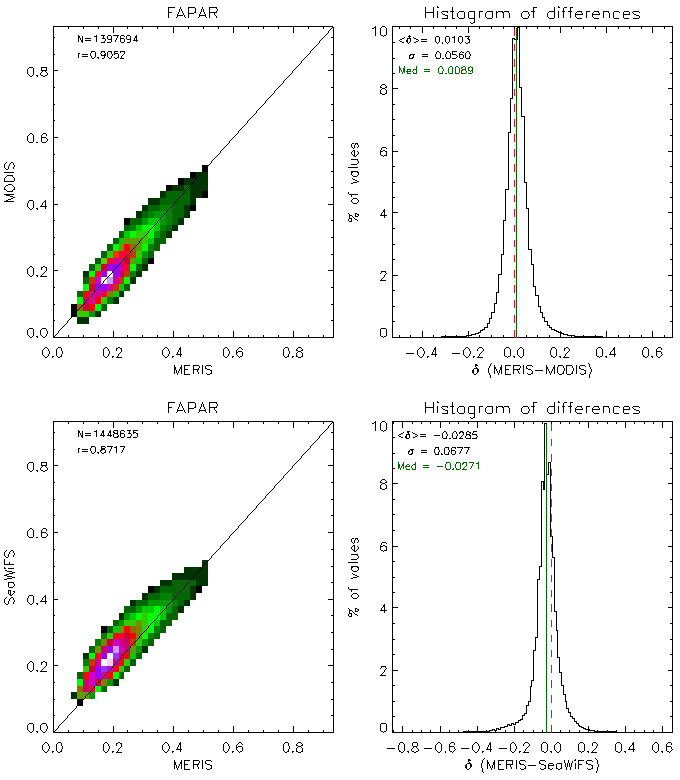
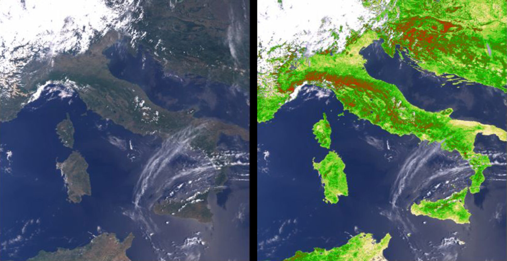
The current validation phase aims to assess the accuracy and the quality of the algorithm products by comparing the MERIS operational Level-2 geophysical product (MGVI) generated at reduced spatial resolution with similar ones generated from other sensors. In order to perform the comparison exercise, it is critical to acquire cloud-free remote sensing measurements over the same geographical regions and at approximately the same acquisition time from various space-borne instruments. This comparison is conducted using daily (instantaneous) products over geographically limited regions, as well as 10-day and monthly composite products over Europe. Evaluations of the FAPAR products against ground-based estimations have also been initiated over some Earth Observing System (EOS) validation sites
The MERIS and MODIS monthly composite FAPAR products, generated using the JRC generic algorithm, have been found to be in good agreement. The effort that has gone into designing the processing algorithm to evaluate the quality of the MGVI and comparable products has been a complicated task. However, the resulting processing power is proving very successful, and importantly, is contributing significantly to the MERIS validation programme ensuring that MERIS is delivering accurate results.

Vegetation plays the most crucial of roles to life on Earth – it provides food for animals and humans, it provides habitats and raw materials for human needs and is fundamental to the Earth's carbon cycle. With the data derived from MERIS, scientists are able to monitor rates of photosynthesis and build up a picture of the state of health of our plant cover and identify areas suffering stress from such things as drought, fire, and ultimately climate change.