Payload Module command, control and communication
Payload Module command and control is performed through:
|
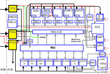
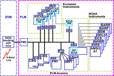
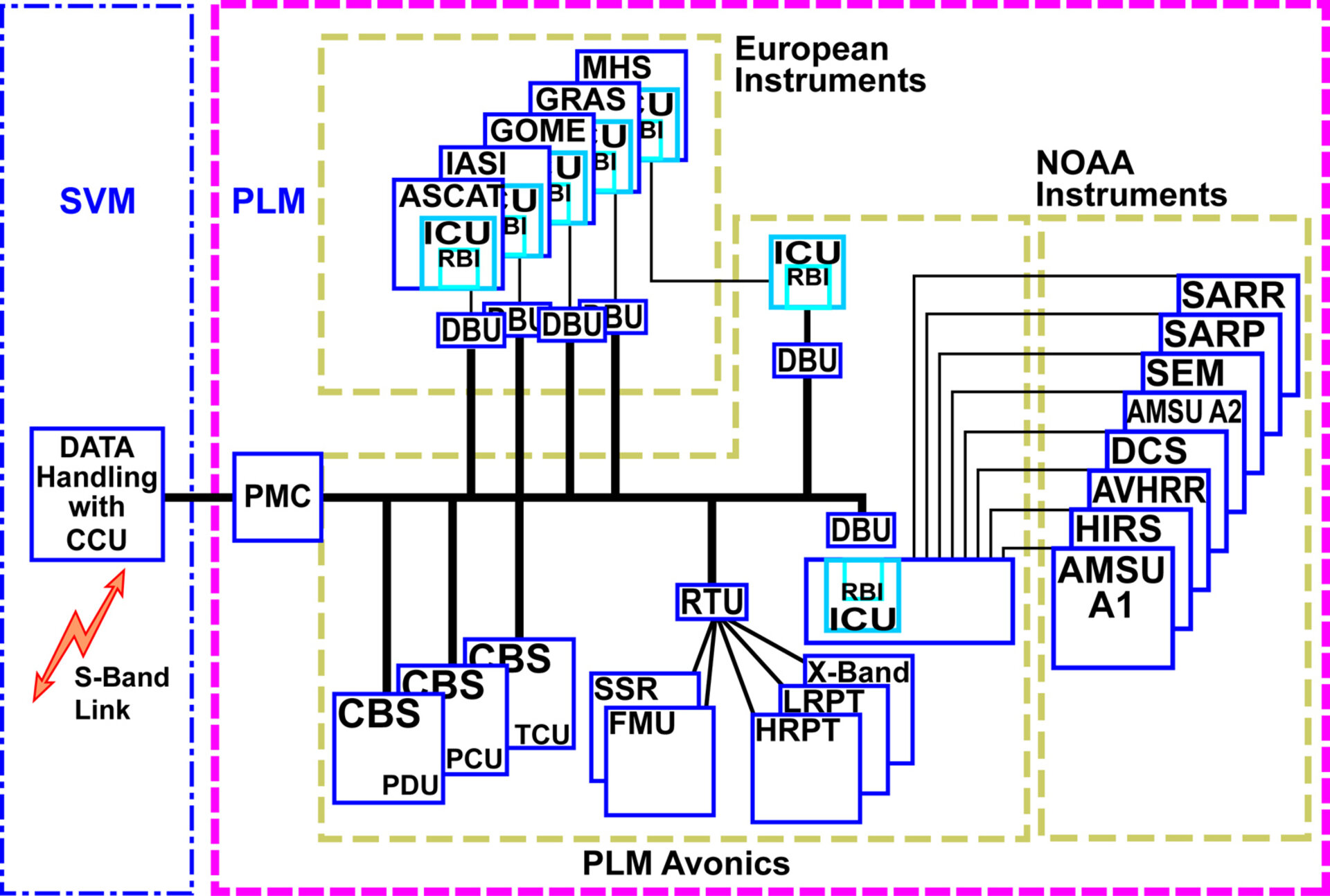
- Payload Module Computer (PMC) - Standard Bus Couplers (CBSs) - Remote Terminal Unit (RTU) - Digital Bus Units (DBUs) - Standard Remote Bus Interface ASICs (RBIs) - Intelligent Control Units (ICUs) |
The PMC controls all PLM equipment and instruments via an ESA standard On Board Data Handling (OBDH) bus.
PLM equipment is controlled via:
- non-intelligent CBSs for power units
- an RTU for control of the other PLM equipment
- Intelligent Control Units (ICUs) for de-centralised instrument control
To safeguard a common hardware interface to the OBDH bus, standard DBUs are used, and are equiped with standard Remote Bus Interface (RBI) chips inside the various ICUs.
For the National Oceanic and Atmospheric Administration (NOAA) instruments a dedicated NOAA Interface Unit (NIU) and for the Microwave Humidity Sounder (MHS) a MHS Protocol Unit (MPU) have been introduced to adapt the dedicated instrument interfaces to the OBDH standard and to provide the ICU functionality. These units also adapt the respective instruments measurement data interface to the ESA standard and are therefore also part of the measurement data chain.
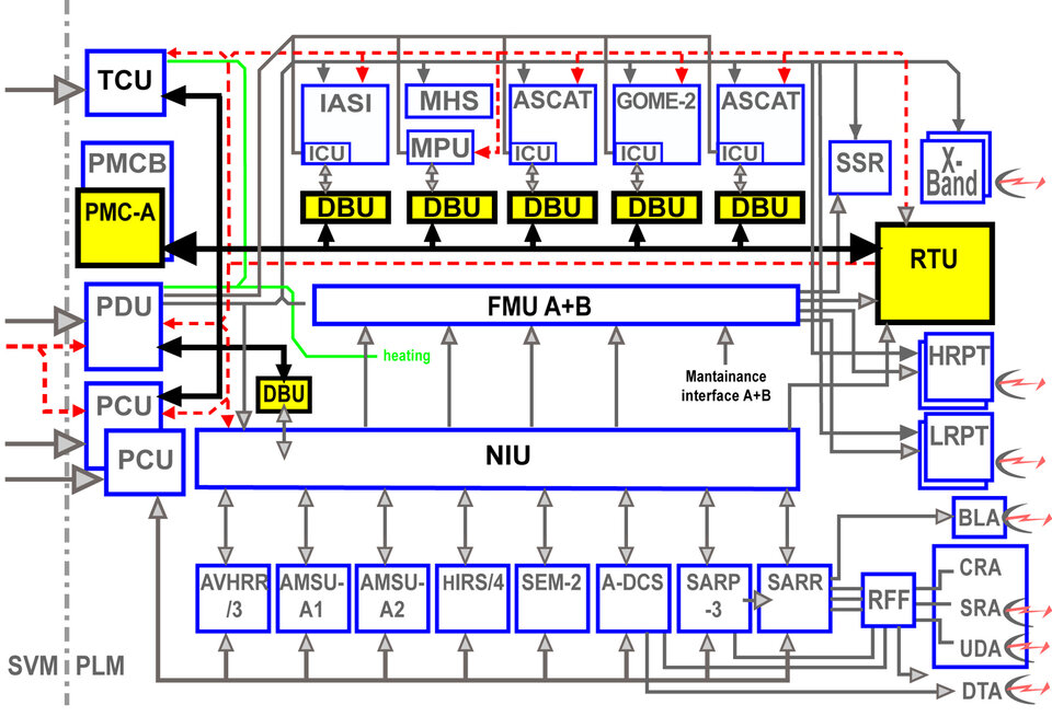
Overview of the command and control elements of the PLM.
Payload Module ground communication: Measurement data transmission to ground
Three independent Radio Frequency (RF) links transmit measurement data to the ground:
- X-band Global Data, 70 Mbps at 7.8 GHz
- L-band HRPT, 3.5 Mbps at 1.7 GHz
- VHF band LRPT, 72 Kbps at 137 MHz
X-band is used to dump global data once per orbit to a northern ground station. The system supports scenarios with only one station like Svalbard (N) as well as a two station scenario with an European station like Kiruna (S) in combination with an American station like Fairbanks (Alaska).
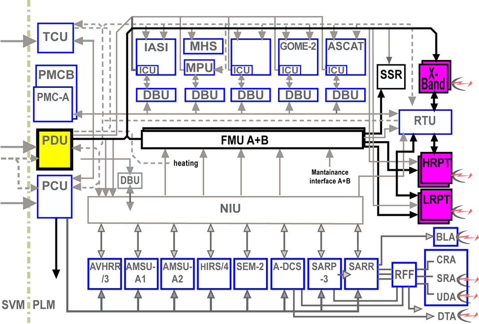
To support local users with local measurement data in a similar way to the TIROS satellites, MetOp is equipped with a Low (LRPT) and a (HRPT) High Resolution Picture Transmission link. Both data streams provide real-time data only, i.e. only measurement data from the area the satellite is scanning during fly-over can be acquired. HRPT contains the complete instrument data, LRPT provides HIRS/4,AMSU A1/A2, MHS, SEM and data from only three compressed channels of the Advanced Very High Resolution Radiometer (AVHRR) instrument.