
SMOS detects freezing soil as winter takes grip
ESA’s SMOS satellite is designed to observe soil moisture and ocean salinity, but this innovative mission is showing that it can also offer new insight into Earth’s carbon and methane cycles by mapping soil as it freezes and thaws.
The launch of the Soil Moisture and Ocean Salinity (SMOS) mission in November 2009 opened up a new era of monitoring Earth using a new remote-sensing technique.
The satellite is capturing images of ‘brightness temperature’. These images correspond to microwave radiation emitted from Earth’s surface and can be related to soil moisture and ocean salinity.
Variability in soil moisture and ocean salinity is a consequence of the continuous exchange of water between the oceans, the atmosphere and the land – Earth’s water cycle.
While SMOS provides essential information for understanding the water cycle, weather and climate system, scientists from the Finnish Meteorological Institute have recently developed a method of using the data to detect and map frozen soils.
Not only can the extent be mapped, but also the depth of the frozen layer can be inferred.
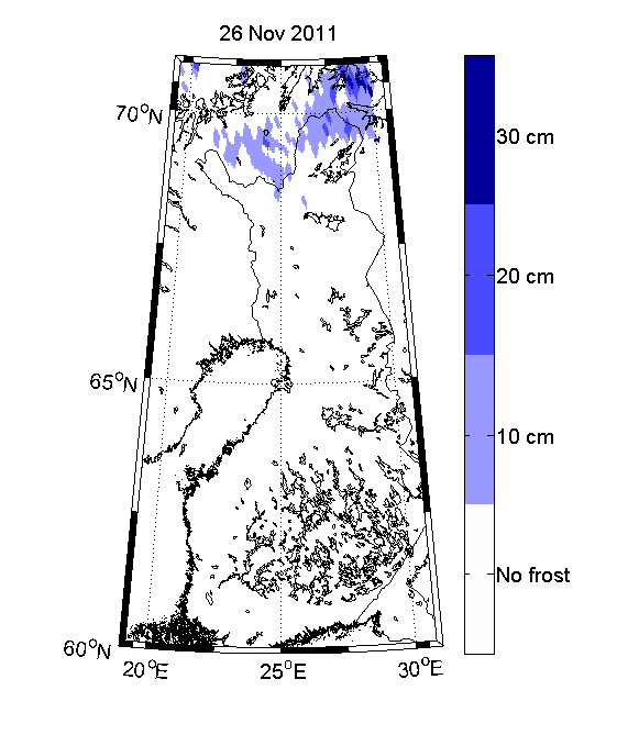
The animation shown above compares data from 26 November 2010 and 26 November 2011. Last year large parts of northern Finland were frozen to depths exceeding 30 cm. This year, however, autumn has been much milder and only a small area had frozen by 26 November.

Interestingly, as the next maps show, the advance of winter this year can be closely monitored.
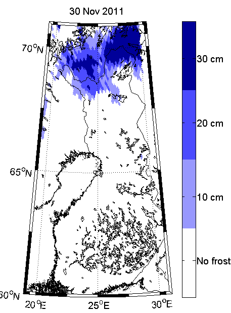
The image on the left shows the state of the soil on 26 November and one below shows how much more soil has frozen just four days later.
As soil freezes every year, it stores large amounts of carbon and methane, which are released back into the atmosphere when it thaws in the spring.
Moreover, there is great concern that rising global temperatures will cause permanently frozen soil, permafrost, in high latitudes to thaw – releasing massive volumes of carbon and methane and adding further to the greenhouse effect.
Dr Kimmo Rautiainen from the Finnish Meteorological Institute (FMI) said, “The state of the soil has always been of particular interest in northern latitudes.
“Detecting frozen soils and the depth to which they are frozen from space has been an unresolved scientific problem.
“However, we are now confident that the novel observations provided by the SMOS mission will help advance our understanding of processes occurring in cold regions.”
Using SMOS data, the scientists have developed a method of inferring the depth of the frozen layer.
During the freezing process, brightness temperatures increase until the top 50 cm of the soil is frozen. Over winter the readings remain stable, even under the presence of deep snow. Thawing in spring then leads to a decrease in brightness temperature.
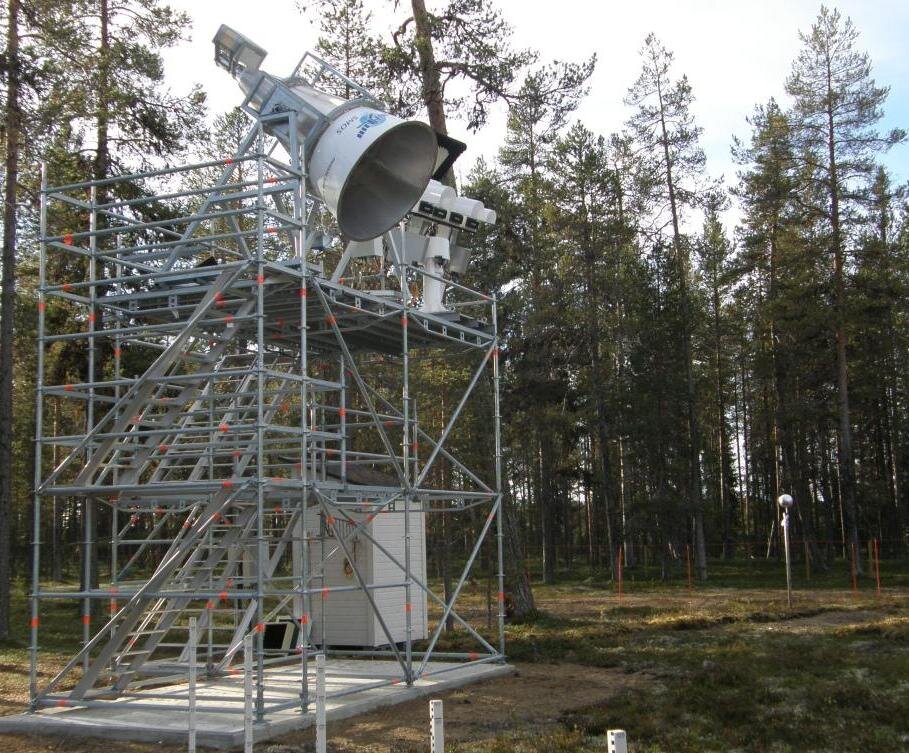
The SMOS data have been validated by observations taken from a ground-based radiometer at FMI’s Arctic Research Centre in Sodankylä, northern Finland.
Through a study being carried out within ESA’s Support to Science Element, the methods of detecting frozen soil will be refined further.
It is envisaged that similar data will be produced and released for use in applications such as numerical weather prediction and hydrology.


