

Better flood predictions via satellite navigation technology
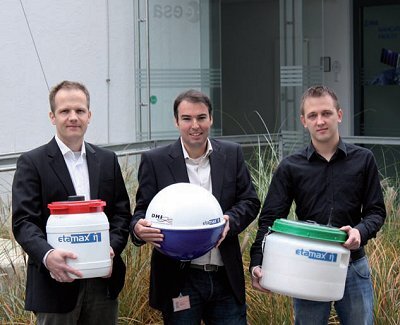
German start-up company Etamax, incubated in ESA’s Technology Transfer Programme’s business incubator in ESOC, has developed an innovative mobile flood monitoring system that uses satellite navigation to measure water levels of rivers in near-real time, enabling authorities to react quickly and thus potentially reduce damage.
Floods represent a worldwide problem that causes economic and ecological devastation of afflicted regions and claim thousands of lives each year. Worldwide climate change and global warming are likely to raise the number of floods considerably.
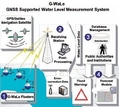
The extent and occurrence of floods are hard to predict, as most flood measuring methods nowadays lack accurate real-time data of the development of the water levels. Etamax’s G-WaLe system, together with international consultancy and research institution DHI Wasser & Umwelt, considerably improves flood predictions by using satellite navigation.
G-WaLe is the first mobile water measurement system for rivers that applies global navigation satellite system (GNSS) technologies to report the water level of an endangered river-zone in near real-time.
Holger Sdunnus, CEO of Etamax, was the European Satellite Navigation Competition finalist for Germany’s region of Hesse in 2006.
Todays permanently installed water measurement stations are immobile, expensive, need maintenance and are often limited in their measurement range. G-WaLe offers a flexible solution for collecting water level measurements: it is mobile, thus can be transported to even the remotest regions e.g. of emerging countries, and is operational on very short notice.

A set of G-WaLe floaters can be anchored in the river to provide near real-time positioning measurements, which can then be correlated with a fixed reference station to a user data centre. The collected data can be used for a better calibration of river models for preventive flood protection and to support operational forces in the event of a crisis.
The system can be easily dispatched by ground or air transport to an endangered area and can use satellite navigation services and data forwarding via GSM or satellite communication.
Potential customers for the G-WaLe are, for instance, water boards, governmental institutions, public authorities responsible for water resources and flood management, industry located at river zones with a need for protection of their installations and insurance companies interested in accurate damage forecasts in flooded areas.
The G-WaLe system has successfully demonstrated the proof of concept through laboratory and real-time testing of the floaters in lakes and rivers. Market entry of the product is expected in 2009.
ESA's Technology Transfer Programme Office (TTPO)
The main mission of the TTPO is to facilitate the use of space technology and space systems for non-space applications and to demonstrate the benefit of the European space programme to European citizens. The office is responsible for defining the overall approach and strategy for the transfer of space technologies including the incubation of start-up companies and their funding. For more information, please contact:
ESA's Technology Transfer Programme Office
European Space Agency ESA
Keplerlaan 1, 2200 AG, Noordwijk ZH
The Netherlands
Phone: +31 (0) 71 565 6208
Email: ttp @ esa.int
Website: http://www.esa.int/ttp
This article was published in the 'Space for Business', ESA’s Technology Transfer Programme Newsletter, 2009 issue 1.
