
|
Kortlægning med satellit data 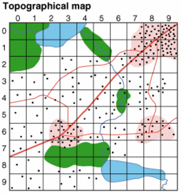 Et simpelt eksempel på korologisk kortlægning kan vise nogle fundamentale egenskaber ved et satellitbillede: I hvert kvadrat i gridnettet tælles antallet af huse. Resultatet af optællingen er en korologisk matrice. Korologisk matrice  Chorological matrix. Histogram  The illustration shows two classification examples based on the histogram shown. One classification has four classes (agriculture, village, town, and other) whereas the other has two (rural and town). Klassifikation  Suitable classification depends on the purpose of the map.  Classification often requires compromise.  A digital image is a chorological matrix. The size of the squares in the grid is equal to the spatial resolution of the (satellite) image and depend upon the instrument providing the data. Similarly the numbers in the grid are determined by the ability of the equipment to distinguish variations. Digital images often contain values between 0 and 255, which are matched exactly by the capacity of 1 byte in the computer. |