| |
Storm surges
|
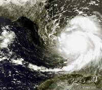
Hurricane Katrina
|
| • | Introduction (http://www.esa.int/SPECIALS/Eduspace_Disasters_EN/SEMVX9WX7YG_0.html) |
|
Exercises
|
| • | Exercise 1: Spiraling Hurricane Katrina from cloud tops to ocean waves (http://www.esa.int/SPECIALS/Eduspace_Disasters_EN/SEM02AWX7YG_0.html) |
|
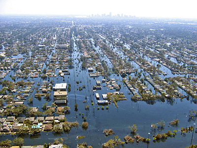
| • | Exercise 2: Visualising and examining flooded areas in New Orleans caused by Hurricane Katrina (http://www.esa.int/SPECIALS/Eduspace_Disasters_EN/SEMS1BWX7YG_0.html) |
|
Related links
|
| • | Hurricane Katrina - NOAA (http://www.katrina.noaa.gov/) |
|
| • | Hurricane Katrina - Wikipedia (http://en.wikipedia.org/wiki/Hurricane_Katrina) |
|
| • | National Hurricane Center - NOAA (http://www.nhc.noaa.gov/) |
|
| • | Storm surge overview - NOAA (http://www.nhc.noaa.gov/ssurge/ssurge_overview.shtml) |
|
| • | Global Monitoring for Environment and Security - ESA (http://www.esa.int/esaLP/LPgmes.html) |
|
| • | International Charter Space and Major Disasters (http://www.disasterscharter.org/) |
|
| • | Tropical weather and hurricanes - Physicalgeography (http://www.physicalgeography.net/fundamentals/7u.html) |
|
Related news
|
| • | Envisat sees whirling Hurricane Katrina from ocean waves to cloud tops (http://www.esa.int/esaCP/SEMB41A5QCE_index_0.html) |
|
Related videos
|
| • | Cyclone Floyd - 9 September 1999
(0.7 Mb) (http://www.esa.int/SPECIALS/Eduspace_Disasters_EN/SEMJ52PK2AG_0.html) |
|
| • | Cyclone Floyd - 13 September 1999
(1.5 Mb) (http://www.esa.int/SPECIALS/Eduspace_Disasters_EN/SEM782PK2AG_0.html) |
|
| • | Cyclone Floyd - 14 September 1999
(1.6 Mb) (http://www.esa.int/SPECIALS/Eduspace_Disasters_EN/SEM892PK2AG_0.html) |
|
| • | Cyclone Floyd - 15-16 September 1999
(3.4 Mb) (http://www.esa.int/SPECIALS/Eduspace_Disasters_EN/SEMF72PK2AG_0.html) |
|