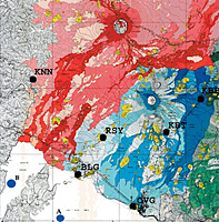
| | |  | Geological map of Virunga National Park | |
Change detection and hazard assessment: Worksheet introduction
In these exercises we will concentrate on the eruption of January 2002 (Nyiragongo) and February-April 2001 (Nyamuragira). By using Landsat images dating back to 1975, we can monitor the changes of the volcanoes over a long time frame, including the major 1977 Nyiragongo eruption.
In the following exercise we will learn about:
- inspecting a volcano
- detecting lava and monitoring changes by performing supervised classification
- detecting long-term changes by visual interpretation
By ‘monitoring’ we refer to observations of dynamic processes and changes over time (multitemporal). This is enabled by satellites that fly in defined orbits and have the possibility of observing the same spot on Earth at regular intervals. Large satellite archives exist that allow us to look at past dates. The Landsat programme, for example, exists since 1972, and aerial images from even earlier.
Satellite sensors acquire information at different wavelengths of the electromagnetic spectrum (multispectral) and can therefore detect features which cannot be identified in the visible part of the spectrum. Satellite images also cover large areas which can be used to monitor large regions or regions which cannot be observed from Earth (such as hostile terrain) or to get an overview of a region which cannot be achieved on the ground. Less logistical effort is required, and satellite images can act as an alternative to field survey. Applying change detection methods enables the detection of changes in a satellite image that occurred on Earth.
| | 2002 eruption - Nyiragongo | |
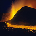
2002 Eruption - Nyiragongo
The situation in Goma: City streets became paths for rough-surfaced lava flows, numerous buildings collapsed and/or burned. The northern part of the airport runway was covered by lava, and access to some parts of the town was cut off. Lava flows destroyed both residential and business districts and a cathedral. Two main streams of lava flows travelled through Goma, one passing right through the town to enter Lake Kivu, which resulted in a lava delta. It was feared that the entering lava could disturb the lake sufficiently to release significant amounts of carbon dioxide and methane gas lying at the lake bottom. Luckily this was not the case.
| | | Nyiragongo volcano |
Out of the 400 000 inhabitants, 250 000 were displaced. It is estimated that 147 people died due to the collapse of houses caused by seismic activity.
| | Nyamuragira volcano | |
2001 Eruption - Nyamuragira
The eruption began on 6 February 2001 with a swarm of volcanic earthquakes, and continued until at least 2 March. The Goma Volcanological Observatory reported that the Nyamuragira eruption started with the opening of two fissures (crack through which lava erupts) from the summit crater extending to the N and S flanks. Two cones formed at the beginning of the eruption, lava flows travelled north and southwards. The Goma-Rutshuru and Kalengera-Tongo roads were threatened of being cut off by the lava flows. Ash from the eruption blew W, destroying ~50 km2 of pasture land and ~150 km2 of crops in the towns of Rusayo, Kirolirwe, Burungu, the southern part of Kichanga, the Masisi territory and Minova. Areas up to 30 km from the eruption site, including the highly populated town of Goma, were also affected.
Inhabitants experienced fever, diarrhoea, headaches, conjunctivitis, and respiratory problems as a result of the ash and gas. On 2 March, a new eruption started on Nyamuragira's S flank, and lava flows reached lengths of 10-20 km as they travelled N, SE, and SW (figure 17). By mid-March, volcanologists reported that the intensity of the lava flows had decreased, but that there were still large amounts of smoke visible.
Data
In this exercise we will use Landsat data. This is because Landsat images date back to 1972, have quite a high resolution, and are available for free online download. Moreover, the images are available at dates closely before and after big eruptions. The main reason why no other optical images are included is that it is nearly always cloudy in this area, and only a few Landsat images of the past years are almost cloud free. Radar images would be required to penetrate clouds (e.g. from Envisat ASAR, ERS-SAR or Radarsat).
| Sensor | Date | Comments | | Landsat 2 - MSS | 12 Mar 1975 | Almost no clouds, some sensor errors | | Landsat 2 - MSS | 6 Feb 1978 | No clouds, some sensor errors | | Landsat 5 - TM | 07 Aug 1987 | Almost no clouds, good quality | | Landsat 5 - TM | 17 Jan 1995 | Cloudy | | Landsat 7 - ETM+ | 11 Dec 2001 | Right before 2002 eruption, few clouds | | Landsat 7 - ETM+ | 15 Jan 2003 | Volcanic plume of Nyiragongo, lava well visible | | Landsat 7 - ETM+ | 31 Jan 2003 | Small plume and a few clouds above Nyiragongo lava |
|
Which images would you prefer for a change detection analysis of the volcanoes?
2001 is an image with just a few clouds, and was acquired right before the Nyiragongo eruption of 2002, but after the Nyamuragira eruption of 2001.
2003-01-31 is an image almost without clouds, but unfortunately there are clouds and a small volcanic plume exactly above the 20023 lava.
2003-01-15 shows the volcanic plume, but half of the image is covered by clouds. Despite the area with the lava of Nyiragongo 2002 being clearly visible, the one of Nyamuragira is not.
We will therefore use 2001, 2003-01-15 and 2003-01-31. We will use the images of 1975 and 1978 for visual analysis of the Nyiragongo 1977 eruption, as well as images of 1987 and 1995 for a visual time series.
Preparation
- Download the Nyiragongo_Landsat.zip file and save the images on your hard drive.
- Read the Remote Sensing Principles on the Eduspace website.
- The Etna exercises provide a good background and overview.
- Open LeoWorks.
| |