| | Volcano monitoring
Terrestrial monitoring
Local authorities place volcano observatories and research centres on several active volcanoes. They monitor geophysical and geochemical parameters which are known to vary before a volcanic eruption. The following techniques are used for the terrestrial monitoring of a volcano:
- Seismic monitoring
- Permanent Global Navigation Satellite Systems (GNSS) stations
- Automated geodimeter
- Doppler radar
- Gas monitoring
- Geochemical analysis of lava and sublimates
Webcams
Cameras can be placed on the ground to monitor volcanoes. Some can be viewed on the web (e.g. USGS - Volcano Hazards).
Remote Sensing Techniques
Satellites help us monitor the status of volcanoes. Volcanoes can be clearly identified on the Earth’s surface. They release gas and particles in the atmosphere, they are hot, they experience topography and land cover changes, deform prior to and during eruptions, and show precursor signs (unlike earthquakes). Often, volcanic activity is coupled with seismic (earthquakes, tsunamis) or geomorphological processes (landslides, mudflows). The following phenomena can be observed by means of satellite remote sensing:
- Volcanic plumes
- Thermal anomalies
- Lava flows
- Topography
- Land cover changes
- Deformation
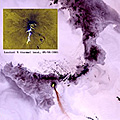
Remote sensing of volcanic plumes
Why: Air traffic security, climate impact, observation of eruptive activity
- Satellites: NOAA (AVHRR), Meteosat (Seviri), Terra/Aqua (MODIS, ASTER), Landsat, SPOT etc.
- Spatial Resolution required: >1km
- Temporal resolution required: real-time to a few days
- Information: Plume dispersion (wind), plume height, SO2, plume temperature
Observation of thermal anomalies
Why: hot spot detection on remote volcanoes, monitoring of lava flows, study of cooling of lava flows, monitoring of lava domes
- Satellites: Terra/Acqua (MODIS), NOAA (AVHRR), ASTER, Landsat
- Spatial Resolution required: 1km to 1m
- Temporal resolution required: real-time to a few weeks
- Information: Hot spot detection
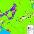
Lava detection
Why: assessment of which land cover types are affected, if populations or infrastructures are endangered, to study the detection of lava and its change over time
- Satellites: optical instruments (Landsat, SPOT, ASTER) , radar images, and radar coherence products
- Spatial Resolution required: 5m to 50m
- Temporal resolution required: weeks to years
- Information: lava detection and classification of different ages of lava
|  | Band combination 4-5-3 of Landsat image from 31 January 2003 | |
Topography and land cover changes
Why: lava and pyroclastic deposits modify the surface, 3D mapping of changes to evaluate risks of motion and to monitor the recovery of an area, vegetation succession after an eruption
- Satellites: High-resolution optical stereo satellites, airborne images, LIDAR
- Spatial Resolution required: 1m
- Temporal resolution required: hours to years
- Information: High resolution DEM
Deformation monitoring
Why: Medium term monitoring (inflations, deflations, unrest detection), short term monitoring (fissures and dyke injections, active faults monitoring, subsidence of lava flows monitoring, surveillance of unstable areas)
- Satellites: Interferometric image pairs of radar satellites (Envisat, ERS, ALOS, TerraSAR-X, JERS)
- Spatial Resolution required: 1m to 50m
- Temporal resolution required: real-time to a few months
- Information: precursors of eruption
| |