ESA
Education
Inicio
Tiempo y clima
Cambio global
Desastres naturales
Terremotos
Introducción
El terremoto de Izmit
Huracanes
Marejadas ciclónicas
Huracán Katrina
Inundaciones
Tesalónica (Grecia)
Volcanes
Introducción
Cinturón volcánico de los Andes
Etna
Nyiragongo y Nyamuragira
Búsqueda
Article Images
Ejercicio 2: Visualización y examen de las áreas de Nueva Orleans inundadas por el huracán Katrina, continuación
Volver al articulo
Download:
HI-RES JPEG
(Size:
57 kb
)
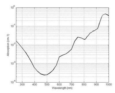
Absorption of water with respect to the wavelength of the incident radiation.
Credits: Zhun310, http://en.wikipedia.org/wiki/File:Figure_2_The_absorption_spectrum_of_water.jpg
Marejadas ciclónicas
Introducción
Huracán Katrina
Introducción
Ejercicios
Ejercicio 1: Vista del huracán Katrina desde las nubes hasta el océano
Ejercicio 2: Visualización y examen de las áreas de Nueva Orleans inundadas por el huracán Katrina
Eduspace - Software
LEOWorks 3
Eduspace - Download
Envisat and SPOT data (zip)
Related links
Hurricane Katrina - NOAA
Hurricane Katrina - Wikipedia
National Hurricane Center - NOAA
Storm surge overview - NOAA
Global Monitoring for Environment and Security - ESA
International Charter Space and Major Disasters
Tropical weather and hurricanes - Physicalgeography
Related news
Envisat sees whirling Hurricane Katrina from ocean waves to cloud tops
Related videos
Cyclone Floyd - 9 September 1999
(0.7 Mb)
Cyclone Floyd - 13 September 1999
(1.5 Mb)
Cyclone Floyd - 14 September 1999
(1.6 Mb)
Cyclone Floyd - 15-16 September 1999
(3.4 Mb)
Copyright 2000 - 2014 © European Space Agency. All rights reserved.