The ERS-1 and ERS-2 satellites were built by European industry under the management of ESA.
The satellites were launched in 1991 and 1995 respectively. They are equipped with an active microwave system that can acquire data through thick cloud cover and during the night. One of the instruments, the scatterometer, measures wind direction and speed over the oceans. Another sensor, the altimeter, can measure wave
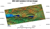
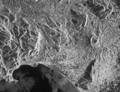
height. The best known sensor, however, is the Synthetic Aperture Radar (SAR), which images the Earth's surface. The data derived is then used for mapping. The interpretation of a SAR image is very different from that of an optical or infrared sensor. SAR images do not show colours but provide information linked to surface roughness.
For a SAR sensor, a sea surface with medium to high waves caused by wind is an example of a rough surface, whilst a calm sea or one with only very small waves is a smooth surface. On land, a forest is a rough surface and will appear bright, while grassland or a highway would appear very dark, as they represent relatively smooth surfaces for the radar.
The mapping and monitoring of sea ice advance and retreat in Arctic waters has become possible thanks to the all-weather radar sensor. It is useful in assisting the study of global climatology, as changes in sea ice area reflect changes in temperature and sea currents. Another important global ecological issue is monitoring deforestation of the
tropical rainforest. Radar sensors can detect forest clearings despite the cloudy weather of the tropics.
An Along-Track Scanning Radiometer (ATSR) scanner was installed on the ERS-2 satellite. This is a traditional passive scanner with 7 channels in the visible, near infrared, and thermal infrared ranges. The thermal infrared channel is especially useful for sea surface temperature mapping. The visible and near infrared channels may be used for global mapping of vegetation with a spatial resolution of 1 km.
ERS-2 is also equipped for global mapping of the ozone layer. Data from ERS-2 plays a vital part in scientific understanding of the variations of the ozone layer and in the assessment of the part played by human-induced pollution.
 | |
Earth observation satellites
|
| • | Introduction (http://www.esa.int/SPECIALS/Eduspace_EN/SEM7YN6SXIG_0.html) |
|
| • | Landsat (http://www.esa.int/SPECIALS/Eduspace_EN/SEMHB04Z2OF_0.html) |
|
| • | RESURS (http://www.esa.int/SPECIALS/Eduspace_EN/SEMQ614Z2OF_0.html) |
|
| • | Envisat (http://www.esa.int/SPECIALS/Eduspace_EN/SEMR314Z2OF_0.html) |
|
| • | SPOT (http://www.esa.int/SPECIALS/Eduspace_EN/SEMIW04Z2OF_0.html) |
|
Meteorological satellites
|
| • | Meteosat (http://www.esa.int/SPECIALS/Eduspace_EN/SEM6BY3Z2OF_0.html) |
|
| • | Meteosat Second Generation (http://www.esa.int/SPECIALS/Eduspace_EN/SEMTNY3Z2OF_0.html) |
|
| • | MetOp (http://www.esa.int/SPECIALS/Eduspace_EN/SEMS1O6SXIG_0.html) |
|
| • | NOAA (http://www.esa.int/SPECIALS/Eduspace_EN/SEMDQY3Z2OF_0.html) |
|
Earth Explorer satellites
|
| • | Introduction (http://www.esa.int/SPECIALS/Eduspace_EN/SEMUYN6SXIG_0.html) |
|
| • | GOCE (http://www.esa.int/esaLP/LPgoce.html) |
|
| • | SMOS (http://www.esa.int/esaLP/LPsmos.html) |
|
| • | CryoSat-2 (http://www.esa.int/esaLP/LPcryosat.html) |
|
Commercial high resolution optical satellites
|
| • | IKONOS (http://www.esa.int/SPECIALS/Eduspace_EN/SEMI714Z2OF_0.html) |
|
| • | QuickBird (http://www.esa.int/SPECIALS/Eduspace_EN/SEMZ814Z2OF_0.html) |
|
| • | WorldView (http://www.esa.int/SPECIALS/Eduspace_EN/SEM43O6SXIG_0.html) |
|
More information
|
| • | ERS-1 and 2 (http://www.esa.int/esaCP/GGGWBR8RVDC_Benefits_0.html) |
|
| • | ERS technical site (http://earth.esa.int/ers/) |
|
| • | Radar technology (http://www.esa.int/SPECIALS/Eduspace_EN/SEMHUESTGOF_0.html) |
|
| • | Technical specifications - ERS 1 and 2 (http://esamultimedia.esa.int/docs/eduspace/ERS.pdf) |
|