|
MetOp
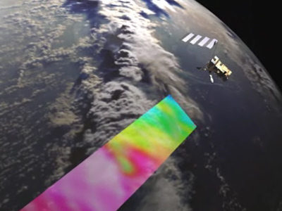
It forms the space segment of EUMETSAT's Polar System (EPS). Launched on 19 October 2006, MetOp-A, the first satellite in the series, replaces one of two satellite services previously operated by NOAA, and is Europe’s first polar-orbiting satellite dedicated to operational meteorology. Responsibilities for the meteorological satellite services offered by MetOp are shared between the U.S. and Europe. MetOp-A has been designed to work with the NOAA satellite system. Together, the two satellite series provide global coverage, and data collected by all the satellites are shared and exchanged between NOAA and EUMETSAT. MetOp-A’s polar orbit is Sun synchronous, so that the satellite track along the Earth is always at the same local time, in this case in the mid-morning. NOAA continues to operate its mid-afternoon orbit satellite service as part of the Polar Orbit Environmental Satellites (POES) system. Polar orbiting satellites orbit at a lower altitude – typically 800 km compared with 36 000 km for a geostationary satellite – and can observe the Earth in closer detail. This global observing system provides invaluable meteorological data from polar orbit to users within 2 hours and 15 minutes of the measurements being taken, with regional users being able to receive data in real time. With an array of sophisticated instrumentation, MetOp-A provides data of unprecedented accuracy and resolution on a host of different variables such as temperature and humidity, ocean surface wind speed and direction, and concentrations of ozone and other trace gases – thus marking a major advance in global weather forecasting and climate monitoring capabilities. In addition, this new weather satellite provides imagery of land and ocean surfaces as well as search and rescue equipment to aid ships and aircraft in distress. A data relay system is also on-board, linking up to buoys and other data collection devices. Of the instruments on board, five are new-generation European instruments, whilst the others have a well-proven heritage and have been provided by NOAA and the French Space Agency (CNES).
The following MetOp satellites will be launched, nominally each 5 years, to ensure the delivery of continuous, high-quality global meteorological data until at least 2020.
Last update: 20 January 2011
| ||||||||||||||||||||||||||||||||||||||||||||||||||||||||||||||||||||||||||||||||||||||