|
ESA’s Earth Explorers What are the Earth Explorers? One of ESA’s objectives is to increase knowledge on climate change, and establish programmes for the accurate monitoring of the Earth. For this purpose, the Earth Explorer programme was set up with the goal of launching six satellites between 2009 and 2013. These satellites will contribute to research on global warming by measuring several climatic aspects, such as the hydrological cycle, ice on Earth, and the atmosphere.
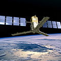
The first two Earth Explorer satellites were launched in 2009: GOCE, the gravity mission, and SMOS, the water mission. CryoSat-2, the ice mission, was launched in April 2010. The other satellites will be launched into space in the upcoming years.
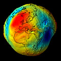
The Gravity field and steady-state Ocean Circulation Explorer (GOCE) was launched on 17 March 2009, and is the first Earth Explorer satellite in space. It now orbits at a distance of 250 km above our heads, so it is still close enough to feel Earth’s attraction. It is designed to measure the Earth’s gravity field at an unprecedented accuracy. Because of the rotation of the Earth and the location of mountains and trenches in the ocean, the attraction of the Earth to objects and humans is not exactly the same everywhere on our planet. An improved knowledge of the gravity distribution on Earth is useful for many different applications. For example, it can improve the measurement of sea level changes. Also, since it is a global measurement, it provides a common reference system for international projects.
On 2 November 2009, the Soil Moisture and Ocean Salinity (SMOS) satellite was launched. It was built to provide information for hydrological and oceanic research. Soil moisture research is important for countries suffering from droughts, but also for the improvement of weather forecasting on seasonal scales and for extreme weather events.
This satellite has two advanced characteristics. First, it is providing global measurements of soil moisture and ocean salinity, for which we only had sparse measurements until now. Second, the technology integrated in the sensor is for the first time ever being used for Earth measurements. The sensor onboard SMOS measures microwave radiation emitted by the Earth at a frequency of 1.4 GHz (L-band). This method was previously used to find water on Mars, but it is the first time that this technique is used for measurements of the Earth from a satellite.
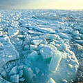
CryoSat-2 is the successor of CryoSat, which was lost after a failed launch in 2005. This satellite, in orbit as of 8 April 2010, is providing information about the state of the ice in the polar seas, in Greenland, and in Antarctica. With the increase in global warming, changes in ice thickness are a major concern, since the melting of glaciers and polar ice can cause a significant rise in sea level, and consequently threaten coastal areas all around the world. Ice also plays a role in the complex process of climate change, by reflecting sunlight. Close and accurate monitoring of ice characteristics by CryoSat-2 is therefore extremely important nowadays. Last update: 20 January 2011
| ||||||||||||||||||||||||||||||||||||||||||||||||||||||||||||||||||||||||||||||||||||||||||||||||