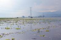
Damaged agricultural fields after extensive flooding
Floods are considered one of the most catastrophic natural disasters. They affect more people than any other natural disaster, posing serious risks for people’s lives, properties and infrastructure. Due to the increasing frequency of severe flood events, as well as evidence of global climate change and rise in sea levels, floods are now considered a serious threat.
Efficient flood monitoring is a fundamental necessity during the crisis and post-crisis phases of each flooding event. It is necessary in order to minimise and evaluate the impact of a flood in terms of human safety and property damage.
Moving in this direction, the European Union Member States have taken important political decisions in order to establish a framework for the assessment and management of flood risks, aiming for a reduction in the adverse consequences for human health, the environment, cultural heritage, and economic activity.
Earth Observation/Remote Sensing and Geographical Information Systems (GIS) are safe, fast and economical means for the monitoring, mapping and managing of floods.
Initiatives, such as the International Charter “Space and Major Disasters” and the Copernicus Emergency Management Service, use satellite data for Earth Observation, providing essential support for large-scale flood events and other natural disasters worldwide.
On 8 October 2006, extensive flash floods occurred in the Prefecture of Thessaloniki, Central Macedonia, Greece, damaging agricultural fields, properties and infrastructure. This case study will study this disaster in more detail.