| | | | |
 |
|
Coastal change Danube Delta change detectionOil spillsDeforestation Bardia National ParkCongo River BasinKameng-Sonitpur Elephant ReserveKilimanjaroRondoniaShillong and GuwahatiIce Antarctica 2003Climate change and glaciersGlacier analysis using radar imageryGlacial retreat in the AlpsGlacier Ice FlowMonitoring of glaciers in the HimalayasRemote sensing of ice and snowUrbanisation CairoCity of KathmanduCórdobaHimalayasKathmandu ValleyLagosVegetation Annapurna Conservation AreaLost in the AndesNgorongoro Conservation AreaNiger Inland DeltaVegetation in South America
| | | | | | | Development of glacial lakes in the Khumbu Himal
This exercise is divided into three parts and requires the use of LEOWorks.
Part 1
In this part of the exercise, we will look at different satellite images of the same region over time. We will observe the growth, over the past 50 years, of the glacial lake on the Imja glacier.
All the data you will need is compressed in the file 'glacier_worksheet2.zip'.
From your folder, open the following data set: '1957_dav_sub.tif'.
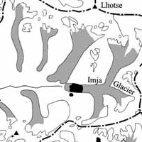
Small glacial lakes on Imja glacier
This is a map of the region which was produced in the late 1950's. The aim of the exercise is to produce one vector layer for each satellite image or map.
| | Part of the Khumbu Himal with glaciers and glacial lakes | |
Using the image shown here, zoom into the end of the Imja glacier, where you can see some small lakes and a bigger one.
1. On which part of the glacier do glacial lakes usually appear?
2. What might be the consequences of the appearance of glacial lakes for the glacier?
In your LEOWorks toolbar, press the GIS button and you will see a new, small window appear. This is the GIS tool.
Click on File>New Theme and name the new file 'Imja_1957', and select polygon as a type of theme.
The next step is to activate the Edit function. Click Edit>Start edit, and you will see that the cursor in the image will become a crosshair. Now start to digitise the boundaries of all the visible small lakes on the Imja glacier (hence without the round lake south of the glacier). Finish the digitising session of an individual lake with a click on the right mouse button.
When you have finished digitising all lakes, click Edit>Stop edit.
To save the digitised boundaries as a vector file, click on the 'shp'-button in the viewer toolbar (You can also click on File>Save Theme). The name of the shapefile should be the same as the one you chose before as a theme name. We have done this and generated the file 'Imja_1957n.shp'.
Continue this step for all the other images (of all the different years) in your folder. Create a new shapefile for each date, and digitise the boundaries of the lake in this specific year. Name the Themes accordingly.
On-screen digitising of the glacial lake boundaries
Once you have digitised all the separate dates (i.e. 1957, 1965, 1976, 1987, 1992, 2000, and 2003), open the first image (1957_dav_sub.tif) and open the GIS Tool for image <…>. Click File>Open Theme and select the dates consecutively. In the opening window, select the following transformation method:
Transformation Method: Arbitrary
Load mode: map based
Theme Information
| |
| | Monitoring of glaciers in the Himalayas IntroductionGlaciersInvestigation areaKhumbu's glaciersImja glacierExercises Location of the study area, Khumbu HimalGlacier retreat at Honku glacierLinks Further ReadingEduspace - Software LEOWorks 3Eduspace - Download glacier_worksheet1.zipglacier_worksheet2.zipglacier_worksheet3.zip
|