| | | | |
 |
|
Coastal change Danube Delta change detectionOil spillsDeforestation Bardia National ParkCongo River BasinKameng-Sonitpur Elephant ReserveKilimanjaroRondoniaShillong and GuwahatiIce Antarctica 2003Climate change and glaciersGlacier analysis using radar imageryGlacial retreat in the AlpsGlacier Ice FlowMonitoring of glaciers in the HimalayasRemote sensing of ice and snowUrbanisation CairoCity of KathmanduCórdobaHimalayasKathmandu ValleyLagosVegetation Annapurna Conservation AreaLost in the AndesNgorongoro Conservation AreaNiger Inland DeltaVegetation in South America
| | | | | | | Glacier retreat at Honku glacier
Page 12 12
Part 1
Glacier retreat at Honku glacier
All the data you will need is compressed in the file 'glacier_worksheet3.zip'
In this exercise you will examine the development of a glacier just south of the Imja valley. The glacier is called Honku, and it is experiencing a retreat like many other glaciers around the world.
The first step is to locate the study area. Open LEOWorks and load the image '2786_04_ref.tif'. Make sure to reset the crop.
This image is the official Nepalese map of the Khumbu area. Get to know the 'pan' and 'zoom' tools in LEOWorks by finding the study area. Sometimes, after pressing the zoom button, it is necessary to click on the scroll bar at the bottom or right hand side of the image to apply the command.
Local names often vary between different sources, so in this case the name of the glacier is 'West Hongu glacier'.
Its location is just south of the mountain ridge in the south of the Imja valley, or in the southwestern part of Ama Dablam.
If you have difficulties finding the location, try cross-checking with the image below.
West Hongu Glacier
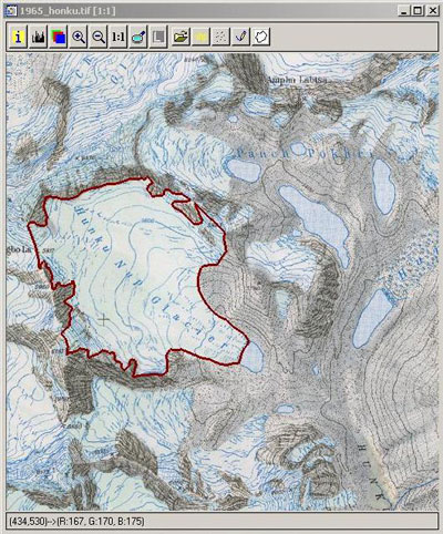
Once you have examined the location of the study area, you can close the image and open the following '1965_honku.tif' image.
This image shows a map of the study area from the year 1965. In this exercise you will use techniques similar to the ones you have used in the previous worksheets.
Open the GIS Tools, and with File > New Theme, create a new polygon theme called 'honku_1965'. Draw the extent of the glacier areas in this image. Don't forget to click on Edit>Start edit before you begin to digitise, and right-click to stop and save the theme afterwards.
When you are finished digitising the extent of the glaciated areas, your image should look like this:
Glacier extent in 1965
Create a new theme named 'lake_1965', and do the same with the glacial lake at the front of the Hunku Nup Glacier on this map.
1. In percentage terms, based on its state in 1965, guess how much the glaciated area will have decreased by 2003?
2. Do you think the area of the glacial lakes will increase? If so, by how much?
3. What are the reasons for global glacier retreat?
4. With the help of the information on the image, calculate the area of the glacier and the area of the lake (area in pixels multiplied by the surface of one pixel in square metres).
Page12
| |
| | Monitoring of glaciers in the Himalayas IntroductionGlaciersInvestigation areaKhumbu's glaciersImja glacierExercises Location of the study area, Khumbu HimalDevelopment of glacial lakes in the Khumbu HimalLinks Further ReadingEduspace - Software LEOWorks 3Eduspace - Download glacier_worksheet1.zipglacier_worksheet2.zipglacier_worksheet3.zip
|